Glendora, Mississippi facts for kids
Quick facts for kids
Glendora, Mississippi
|
|
|---|---|
|
Village
|
|
 |
|

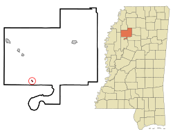
Location of Glendora, Mississippi
|
|
| Country | United States |
| State | Mississippi |
| County | Tallahatchie |
| Area | |
| • Total | 0.14 sq mi (0.37 km2) |
| • Land | 0.14 sq mi (0.37 km2) |
| • Water | 0.00 sq mi (0.00 km2) |
| Elevation | 144 ft (44 m) |
| Population
(2020)
|
|
| • Total | 154 |
| • Density | 1,069.44/sq mi (411.86/km2) |
| Time zone | UTC-6 (Central (CST)) |
| • Summer (DST) | UTC-5 (CDT) |
| ZIP code |
38928
|
| Area code(s) | 662 |
| FIPS code | 28-27660 |
| GNIS feature ID | 2407465 |
| Website | glendorams.com |
Glendora is a small village located in Tallahatchie County, Mississippi. In 2020, about 154 people lived there.
Contents
History of Glendora
Glendora started as a place where white Americans processed wood from trees. Logs were floated down the river from nearby areas like Webb to be cut into lumber here.
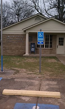
The first small community was actually two miles south of Glendora, at a spot called Black Bayou. When a railroad was built in 1883, a train station was placed there and named Glendora. The village quickly grew around this new station. A post office opened in 1900, and people could vote there.
A big company called Cane Lake Lumber Company built a large sawmill in Glendora. It operated until 1909 before moving to a different location.
Important Events in Glendora's History
In December 1955, a white man named Elmer Kimbrell was involved in a serious incident. He was found not guilty by an all-white jury. This happened shortly after he was connected to the Emmett Till case in Money, Mississippi. At that time, many African Americans in Mississippi could not vote. This meant they could not be part of juries or have a say in the political system.
Geography of Glendora
Glendora is a small village. According to the United States Census Bureau, it covers about 0.1 square miles (0.37 square kilometers) of land. There is no water area within the village limits.
Population and People
| Historical population | |||
|---|---|---|---|
| Census | Pop. | %± | |
| 1910 | 207 | — | |
| 1940 | 247 | — | |
| 1950 | 178 | −27.9% | |
| 1960 | 147 | −17.4% | |
| 1970 | 201 | 36.7% | |
| 1980 | 220 | 9.5% | |
| 1990 | 165 | −25.0% | |
| 2000 | 285 | 72.7% | |
| 2010 | 151 | −47.0% | |
| 2020 | 154 | 2.0% | |
| U.S. Decennial Census | |||
Who Lives in Glendora? (2020 Census)
The United States Census Bureau collects information about the people living in different places. Here's a look at the different groups in Glendora based on the 2020 Census:
| Race / Ethnicity (NH = Non-Hispanic) | Pop 2000 | Pop 2010 | Pop 2020 | % 2000 | % 2010 | % 2020 |
|---|---|---|---|---|---|---|
| White alone (NH) | 13 | 1 | 4 | 4.56% | 0.66% | 2.60% |
| Black or African American alone (NH) | 254 | 146 | 145 | 89.12% | 96.69% | 94.16% |
| Native American or Alaska Native alone (NH) | 2 | 2 | 0 | 0.70% | 1.32% | 0.00% |
| Asian alone (NH) | 0 | 0 | 0 | 0.00% | 0.00% | 0.00% |
| Pacific Islander alone (NH) | 0 | 0 | 0 | 0.00% | 0.00% | 0.00% |
| Some Other Race alone (NH) | 0 | 0 | 0 | 0.00% | 0.00% | 0.00% |
| Mixed Race or Multi-Racial (NH) | 7 | 0 | 3 | 2.46% | 0.00% | 1.95% |
| Hispanic or Latino (any race) | 9 | 2 | 2 | 3.16% | 1.32% | 1.30% |
| Total | 285 | 151 | 154 | 100.00% | 100.00% | 100.00% |
Education in Glendora
Students in Glendora attend schools in the West Tallahatchie School District. The main schools for the area are R. H. Bearden Elementary School and West Tallahatchie High School.
Years ago, Black Bayou Elementary School served children in Glendora. However, the school district closed it in 1998. West District Middle School (now Bearden) used to be the middle school for the area.
For college, Coahoma Community College is the designated community college for students from Glendora.
Famous People from Glendora
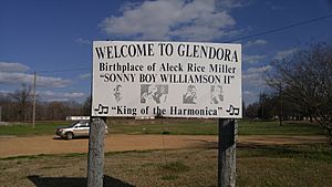
- Sonny Boy Williamson (whose real name was Alex "Rice" Miller) was a very important blues musician. He was born near Glendora in 1912 and is a member of the Mississippi Musicians Hall of Fame.
See also
 In Spanish: Glendora (Misisipi) para niños
 | Jewel Prestage |
 | Ella Baker |
 | Fannie Lou Hamer |


