Leflore County, Mississippi facts for kids
Quick facts for kids
Leflore County
|
|
|---|---|

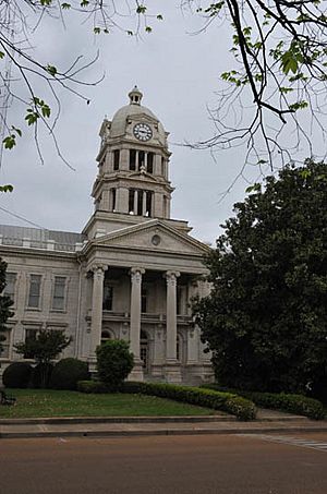
Leflore County Courthouse
|
|

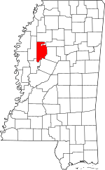
Location within the U.S. state of Mississippi
|
|
 Mississippi's location within the U.S. |
|
| Country | |
| State | |
| Founded | 1871 |
| Named for | Greenwood LeFlore |
| Seat | Greenwood |
| Largest city | Greenwood |
| Area | |
| • Total | 606 sq mi (1,570 km2) |
| • Land | 593 sq mi (1,540 km2) |
| • Water | 14 sq mi (40 km2) 2.3% |
| Population
(2020)
|
|
| • Total | 28,339 |
| • Density | 46.76/sq mi (18.056/km2) |
| Time zone | UTC−6 (Central) |
| • Summer (DST) | UTC−5 (CDT) |
| Congressional district | 2nd |
Leflore County is a county in the state of Mississippi. In 2020, about 28,339 people lived there. The main city and county seat is Greenwood.
The county is named after Greenwood LeFlore, a leader of the Choctaw people. He signed a treaty to give his people's land to the United States. In return, the Choctaw received land in Indian Territory (now Oklahoma). LeFlore chose to stay in Mississippi.
Leflore County is part of the Greenwood, Mississippi micropolitan area. It is located in the Mississippi Delta region. The Yazoo River forms its southern border. Long ago, the lands along the river were used for growing cotton.
Today, Leflore County is mostly rural. It faces challenges, including a high level of child poverty. This is partly because machines replaced many farm jobs in the 20th century. This left fewer opportunities for people. Because of this, the population has decreased a lot since 1930. Many people have moved away to find work.
Contents
History of Leflore County
How Leflore County Was Formed
Leflore County was created in 1871. This was during the Reconstruction era after the American Civil War. It was made from parts of Carroll, Sunflower, and Tallahatchie counties.
The county got its name from Greenwood LeFlore, a Choctaw chief. In the 1830s, during a time called Indian removal, he signed a treaty. This treaty sold the Choctaw's remaining lands east of the Mississippi River to the U.S. Most Choctaw moved to Indian Territory. But LeFlore and some others stayed in Mississippi. He became a U.S. citizen and a farmer. He also served as a politician.
Changes After the Civil War
After the Civil War, many formerly enslaved African Americans in the county became free. They gained the right to vote for the first time. They supported the Republican Party. In the mid-1870s, a group called the Red Shirts formed in Mississippi. They tried to stop Republican meetings and prevent Black people from voting. Their goal was to help white Democrats regain control of the state government.
In 1890, Mississippi passed a new state constitution. This constitution made it very hard for Black people to vote. They used things like poll taxes and literacy tests. These rules kept Black people from participating in politics. This unfair system lasted until the 1960s.
The Great Migration and Civil Rights
In the early 1900s, many Black people left rural counties like Leflore. This was part of the Great Migration. They moved to big cities in the North and Midwest. They were looking for better jobs and education. Many traveled by train to Chicago, bringing their music and culture with them.
Leflore County was an important place for the Civil Rights Movement. This was a time when people fought for equal rights for all. In 1963, over 13,000 Black people in the county were old enough to vote. But fewer than 270 were registered. This was because of unfair rules and fear. Meanwhile, almost all eligible white voters were registered.
The Student Nonviolent Coordinating Committee (SNCC) moved its main office to Greenwood in 1963. SNCC members were arrested for trying to help people register to vote. The U.S. government tried to help them get released. Later, in 1963, 45 people were arrested for protesting attacks on churches. These churches were used for voter registration drives. New laws passed in 1964 and 1965 began to change things.
In 1966, civil rights leaders returned to the county. They were part of the March Against Fear. This march was started by James Meredith. He was shot and hurt during the march. Other leaders continued the march to help register voters. The county government had stopped giving food aid to poor Black families. SNCC helped organize a national effort to get food for the county residents.
In 1966, Stokely Carmichael, a new leader of SNCC, spoke in Greenwood. He talked about "Black Power." He meant that Black people needed to build their own political and economic strength.
Blues Musicians from Leflore County
Leflore County is famous for its blues music. Many talented blues guitarists came from here. Some of the well-known musicians from the county include:
- L.C. Green
- David "Honeyboy" Edwards
- Guitar Slim
- Richard "Hacksaw" Harney
- Luther Johnson (Guitar Junior)
- Robert Johnson
- Rubin Lacey
- Furry Lewis
- Tommy McClennan
- Dion Payton
- Robert Petway
- Brewer Phillips
- Fenton Robinson
- Hubert Sumlin
- Hound Dog Taylor
Geography
Leflore County covers about 606 square miles. Most of this is land (593 square miles). About 14 square miles (2.3%) is water.
Major Roads
Neighboring Counties
- Tallahatchie County (north)
- Grenada County (northeast)
- Carroll County (east)
- Holmes County (southeast)
- Humphreys County (southwest)
- Sunflower County (west)
Protected Natural Areas
- Mathews Brake National Wildlife Refuge
- Theodore Roosevelt National Wildlife Refuge (part)
Population Information
| Historical population | |||
|---|---|---|---|
| Census | Pop. | %± | |
| 1880 | 10,246 | — | |
| 1890 | 16,869 | 64.6% | |
| 1900 | 23,834 | 41.3% | |
| 1910 | 36,290 | 52.3% | |
| 1920 | 37,256 | 2.7% | |
| 1930 | 53,506 | 43.6% | |
| 1940 | 53,406 | −0.2% | |
| 1950 | 51,813 | −3.0% | |
| 1960 | 47,142 | −9.0% | |
| 1970 | 42,111 | −10.7% | |
| 1980 | 41,525 | −1.4% | |
| 1990 | 37,341 | −10.1% | |
| 2000 | 37,947 | 1.6% | |
| 2010 | 32,317 | −14.8% | |
| 2020 | 28,339 | −12.3% | |
| 2023 (est.) | 26,378 | −18.4% | |
| U.S. Decennial Census 1790-1960 1900-1990 1990-2000 2010-2013 |
|||
What the 2020 Census Shows
A census is a count of all the people living in a place. The 2020 census found 28,339 people living in Leflore County.
| Group | Number | Percentage |
|---|---|---|
| White (not Hispanic) | 5,963 | 21.04% |
| Black or African American (not Hispanic) | 20,809 | 73.43% |
| Native American | 15 | 0.05% |
| Asian | 205 | 0.72% |
| Other/Mixed Race | 507 | 1.79% |
| Hispanic or Latino | 840 | 2.96% |
What the 2010 Census Showed
In 2010, there were 32,317 people in the county. About 72.2% were Black or African American. About 24.9% were White. Other groups included Asian, Native American, and people of two or more races. About 2.3% of the population was Hispanic or Latino.
Education
Colleges and Universities
Mississippi Valley State University is located near Itta Bena. The county is also served by Mississippi Delta Community College. Its main campus is in Moorhead.
Schools for Kids
- Public Schools: The Greenwood-Leflore Consolidated School District serves all public school students in the county. It was formed in 2019.
- Greenwood High School
- Amanda Elzy High School
- Leflore County High School
- Private Schools
- Delta Streets Academy
- Pillow Academy
Communities
Cities
Towns
Census-Designated Place
- Mississippi Valley State University
Small Communities (Unincorporated)
Old Towns (Ghost Town)
Images for kids
See also
 In Spanish: Condado de Leflore para niños
 | Emma Amos |
 | Edward Mitchell Bannister |
 | Larry D. Alexander |
 | Ernie Barnes |


