Humphreys County, Mississippi facts for kids
Quick facts for kids
Humphreys County
|
|
|---|---|

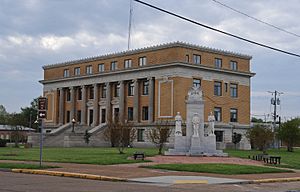
Humphreys County Courthouse
|
|

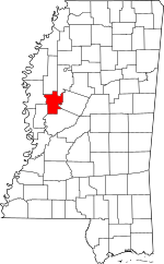
Location within the U.S. state of Mississippi
|
|
 Mississippi's location within the U.S. |
|
| Country | |
| State | |
| Founded | 1918 |
| Named for | Benjamin G. Humphreys |
| Seat | Belzoni |
| Largest city | Belzoni |
| Area | |
| • Total | 431 sq mi (1,120 km2) |
| • Land | 418 sq mi (1,080 km2) |
| • Water | 13 sq mi (30 km2) 3.0% |
| Population
(2020)
|
|
| • Total | 7,785 |
| • Density | 18.063/sq mi (6.974/km2) |
| Time zone | UTC−6 (Central) |
| • Summer (DST) | UTC−5 (CDT) |
| Congressional district | 2nd |
Humphreys County is a county in the state of Mississippi, USA. In 2020, about 7,785 people lived there. The main town, or county seat, is Belzoni. The county is named after Benjamin G. Humphreys. It's Mississippi's newest county, created in 1918. Humphreys County is part of the Mississippi Delta area.
In 1976, Governor Cliff Finch called Humphreys County the 'Farm-Raised Catfish Capital of the World'. This was because it grew more catfish than any other county in the U.S. A huge area of the county, about 40,000 acres (160 square kilometers), is covered in water. This water is used to raise catfish. Around 60% of all farm-raised catfish in the U.S. comes from within 65-mile (105 km) of Belzoni. Other places, like Savannah, Tennessee, and Des Allemands, Louisiana, also say they are "Catfish Capital."
In March 2023, a very strong tornado hit parts of Humphreys County. The towns of Rolling Fork, Midnight, and Silver City were affected. This tornado was part of a larger storm system.
Contents
Geography of Humphreys County
According to the U.S. Census Bureau, Humphreys County covers a total area of 431 square miles (1,120 km2). Most of this area, about 418 sq mi (1,080 km2), is land. The rest, about 13 sq mi (34 km2), is water.
Main Roads
 U.S. Highway 49W
 Mississippi Highway 7
 Mississippi Highway 12
 Mississippi Highway 14
 Mississippi Highway 16
Neighboring Counties
Humphreys County shares borders with several other counties:
- Sunflower County (to the north)
- Leflore County (to the northeast)
- Holmes County (to the east)
- Yazoo County (to the south)
- Sharkey County (to the southwest)
- Washington County (to the west)
Protected Natural Areas
Part of the Theodore Roosevelt National Wildlife Refuge is in Humphreys County. There is also the Sky Lake Wildlife Management Area. This 3,500-acre (1,400 ha) area is special. It has some of the oldest and largest bald cypress trees in the world.
People of Humphreys County
| Historical population | |||
|---|---|---|---|
| Census | Pop. | %± | |
| 1920 | 19,192 | — | |
| 1930 | 24,729 | 28.9% | |
| 1940 | 26,257 | 6.2% | |
| 1950 | 23,115 | −12.0% | |
| 1960 | 19,093 | −17.4% | |
| 1970 | 14,601 | −23.5% | |
| 1980 | 13,931 | −4.6% | |
| 1990 | 12,134 | −12.9% | |
| 2000 | 11,206 | −7.6% | |
| 2010 | 9,375 | −16.3% | |
| 2020 | 7,785 | −17.0% | |
| 2023 (est.) | 7,216 | −23.0% | |
| U.S. Decennial Census 1790–1960 1900–1990 1990–2000 2010–2013 |
|||
Population in 2020
In 2020, the county had 7,785 people. There were 3,186 households and 2,078 families living there.
| Race | Number of People | Percentage |
|---|---|---|
| White | 1,423 | 18.28% |
| Black or African American | 6,072 | 78.00% |
| Native American | 13 | 0.17% |
| Asian | 10 | 0.13% |
| Other/Mixed | 176 | 2.26% |
| Hispanic or Latino | 91 | 1.17% |
Population in 2010
In 2010, there were 9,375 people in Humphreys County. Most people, about 74.5%, were Black or African American. About 23.5% were White. A small number were Asian (0.2%) or Native American (0.1%). About 0.9% were of another race, and 0.7% were of two or more races. People who were Hispanic or Latino made up 2.2% of the population.
Local Media
Humphreys County has its own radio stations and newspapers.
Radio Stations
Both radio stations are located in Belzoni:
- WELZ 1460AM (plays Country music)
- WBYP 107.1FM (also plays Country music)
Newspapers
- The Belzoni Banner is a newspaper printed every week.
- The Enterprise-Tocsin is a newspaper from Indianola in Sunflower County. It is also given out in some parts of northern Humphreys County.
Communities in Humphreys County
Humphreys County has one city, several towns, and some smaller communities.
City
- Belzoni (This is the main county seat)
Towns
Unincorporated Communities
These are smaller places that are not officially towns or cities:
See also
 In Spanish: Condado de Humphreys (Misisipi) para niños
 | Mary Eliza Mahoney |
 | Susie King Taylor |
 | Ida Gray |
 | Eliza Ann Grier |

