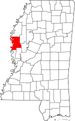
Washington County, Mississippi facts for kids
Quick facts for kids
Washington County
|
|
|---|---|

First National Bank of Greenville
|
|

Location within the U.S. state of Mississippi
|
|
 Mississippi's location within the U.S. |
|
| Country | |
| State | |
| Founded | 1827 |
| Named for | George Washington |
| Seat | Greenville |
| Largest city | Greenville |
| Area | |
| • Total | 761 sq mi (1,970 km2) |
| • Land | 725 sq mi (1,880 km2) |
| • Water | 36 sq mi (90 km2) 4.8% |
| Population
(2020)
|
|
| • Total | 44,922 |
| • Estimate
(2023)
|
41,946 |
| • Density | 59.03/sq mi (22.792/km2) |
| Time zone | UTC−6 (Central) |
| • Summer (DST) | UTC−5 (CDT) |
| Congressional district | 2nd |
Washington County is a county in Mississippi, a state in the United States. In 2020, about 44,922 people lived here. The main city and county seat is Greenville. The county is named after George Washington, who was the first president of the United States. It is located near the border with Arkansas. Washington County is part of the Mississippi Delta region.
Contents
History
Washington County is in the Mississippi Delta. It was first developed for growing cotton before the American Civil War. This time period is called the "antebellum years." Most large farms, called plantations, were built near rivers. Rivers were the main way to transport goods back then. Growing cotton on these farms relied on the forced labor of enslaved people.
In 1860, a study showed that 92.3% of the people in Washington County were enslaved. This was the second-highest percentage in the entire country. Only Issaquena County, also in Mississippi, had a slightly higher number.
Geography
The U.S. Census Bureau says that Washington County covers about 761 square miles. Most of this area, about 725 square miles, is land. The remaining 36 square miles, which is about 4.8%, is water.
Adjacent counties
- Bolivar County (north)
- Sunflower County (northeast)
- Humphreys County (east)
- Sharkey County (southeast)
- Issaquena County (south)
- Chicot County, Arkansas (west)
- Desha County, Arkansas (northwest)
National protected areas
- Holt Collier National Wildlife Refuge
- Theodore Roosevelt National Wildlife Refuge (part)
- Yazoo National Wildlife Refuge
Population Changes
| Historical population | |||
|---|---|---|---|
| Census | Pop. | %± | |
| 1830 | 1,976 | — | |
| 1840 | 7,287 | 268.8% | |
| 1850 | 8,389 | 15.1% | |
| 1860 | 15,679 | 86.9% | |
| 1870 | 14,569 | −7.1% | |
| 1880 | 25,367 | 74.1% | |
| 1890 | 40,414 | 59.3% | |
| 1900 | 49,216 | 21.8% | |
| 1910 | 48,933 | −0.6% | |
| 1920 | 51,092 | 4.4% | |
| 1930 | 54,310 | 6.3% | |
| 1940 | 67,576 | 24.4% | |
| 1950 | 70,504 | 4.3% | |
| 1960 | 78,638 | 11.5% | |
| 1970 | 70,581 | −10.2% | |
| 1980 | 72,344 | 2.5% | |
| 1990 | 67,935 | −6.1% | |
| 2000 | 62,977 | −7.3% | |
| 2010 | 51,137 | −18.8% | |
| 2020 | 44,922 | −12.2% | |
| 2023 (est.) | 41,946 | −18.0% | |
| U.S. Decennial Census 1790-1960 1900-1990 1990-2000 2010-2013 |
|||
Population in 2020
In 2020, the county had 44,922 people. About 71% of the population was Black or African American. Around 25% of the people were White. Other groups, like Asian, Native American, and people of mixed races, made up smaller parts of the population. About 1.3% of the people were Hispanic or Latino.
Population in 2010
In 2010, there were 51,137 people living in Washington County. About 71.3% were Black or African American. Around 27.0% were White. Other groups included Asian, Native American, and people of two or more races. About 1.0% of the population was Hispanic or Latino.
Population in 1990
In 1990, the county had 67,935 people. About 57.5% were Black or African American. Around 41.5% were White. Smaller numbers of people were Native American or Asian. About 0.6% of the population was Hispanic or Latino.
Transportation
Major highways
Airport
The Mid Delta Regional Airport is located in Washington County. It is owned by the City of Greenville.
Education
Washington County has several schools for students.
- Public School Districts
- Greenville Public School District
- Leland School District
- Hollandale School District
- Western Line School District
- Private Schools
- Deer Creek School (Arcola)
- Greenville Christian School
- Saint Joseph Catholic High School (Greenville)
- Washington School (Greenville)
Some students from Washington County also attend Pillow Academy. This school is located in Leflore County. Pillow Academy was originally founded as a "segregation academy." This means it was created to provide separate schooling during a time when schools were being integrated.
Communities
Washington County has several cities, towns, and other communities.
Cities
- Greenville (This is the county seat)
- Hollandale
- Leland
Towns
Census-designated places
These are areas that are like towns but are not officially incorporated as cities or towns.
Unincorporated communities
These are small communities that do not have their own local government.
Ghost towns
These are places that used to be towns but are now abandoned.
- New Mexico (This was the first county seat)
- Port Anderson
- Princeton (This was the second county seat)
See also
 In Spanish: Condado de Washington (Misisipi) para niños
 | Janet Taylor Pickett |
 | Synthia Saint James |
 | Howardena Pindell |
 | Faith Ringgold |

