Desha County, Arkansas facts for kids
Quick facts for kids
Desha County
|
||
|---|---|---|
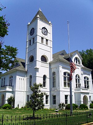
Desha County courthouse in Arkansas City
|
||
|
||
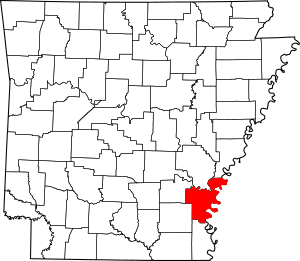
Location within the U.S. state of Arkansas
|
||
 Arkansas's location within the U.S. |
||
| Country | ||
| State | ||
| Founded | December 12, 1838 | |
| Named for | Benjamin Desha | |
| Seat | Arkansas City | |
| Largest city | Dumas | |
| Area | ||
| • Total | 820 sq mi (2,100 km2) | |
| • Land | 768 sq mi (1,990 km2) | |
| • Water | 51 sq mi (130 km2) 6.3%% | |
| Population
(2020)
|
||
| • Total | 11,395 | |
| • Density | 13.90/sq mi (5.37/km2) | |
| Time zone | UTC−6 (Central) | |
| • Summer (DST) | UTC−5 (CDT) | |
| Congressional district | 1st | |
Desha County is a county located in the southeastern part of Arkansas, a state in the United States. Its eastern border is along the famous Mississippi River. In 2020, about 11,395 people lived here. The county seat, which is like the main administrative city, is Arkansas City. Many people who live in Desha County are African American.
Contents
History of Desha County
Desha County was officially created on December 12, 1838. The Arkansas Legislature formed it from parts of Arkansas County and Chicot County. The county was named after Captain Benjamin Desha, a brave soldier who fought in the War of 1812.
This area, known as the Arkansas Delta, has very rich soil. Because of its rivers and good land, large farms grew a lot of cotton here before the American Civil War. These farms often used enslaved people for labor.
After the Civil War, cotton remained the main crop. Farmers continued to do well, often using sharecroppers and tenant farmers. These were people who worked the land for a share of the crops or paid rent.
However, things changed a lot when machines started doing more farm work. Many farm workers, especially African Americans, lost their jobs. Thousands moved to northern or western cities during the Great Migration. This was a time when many African Americans left the Southern states looking for better opportunities. This caused the county's population to shrink.
Today, many farms are very large and use modern methods. Desha County is working to bring back its population and economy. They are trying to improve education and attract visitors. People can enjoy the county's history, culture, and outdoor activities.
During World War II, the U.S. government built a special camp here called the Rohwer War Relocation Center. This camp was for Japanese Americans and people of Japanese descent. They were forced to leave their homes on the West Coast and live in these camps. The camp operated from late 1942 to 1945. Up to 8,500 people lived there. The Rohwer War Relocation Center Cemetery is now a special historic site.
Geography of Desha County
Desha County covers about 820 square miles (2,124 square kilometers). Most of this area, about 768 square miles (1,989 square kilometers), is land. The rest, about 51 square miles (132 square kilometers), is water. Desha County is part of the flat, fertile area called the Arkansas Delta. It is also considered part of the Southeast Arkansas region.
Major Roads in Desha County
You can get around Desha County using several important roads:
 Future Interstate 69
 U.S. Highway 65
 U.S. Highway 165
 U.S. Highway 278
 Highway 1
 Highway 4
 Highway 138
Neighboring Counties
Desha County shares borders with these other counties:
- Arkansas County (to the north)
- Phillips County (to the northeast)
- Bolivar County, Mississippi (to the east)
- Chicot County (to the south)
- Drew County (to the southwest)
- Lincoln County (to the northwest)
Protected Natural Areas
Part of the White River National Wildlife Refuge is located in Desha County. This refuge helps protect wildlife and their habitats.
People of Desha County (Demographics)
| Historical population | |||
|---|---|---|---|
| Census | Pop. | %± | |
| 1840 | 1,598 | — | |
| 1850 | 2,911 | 82.2% | |
| 1860 | 6,459 | 121.9% | |
| 1870 | 6,125 | −5.2% | |
| 1880 | 8,973 | 46.5% | |
| 1890 | 10,324 | 15.1% | |
| 1900 | 11,511 | 11.5% | |
| 1910 | 15,274 | 32.7% | |
| 1920 | 20,297 | 32.9% | |
| 1930 | 21,814 | 7.5% | |
| 1940 | 27,160 | 24.5% | |
| 1950 | 25,155 | −7.4% | |
| 1960 | 20,770 | −17.4% | |
| 1970 | 18,761 | −9.7% | |
| 1980 | 19,760 | 5.3% | |
| 1990 | 16,798 | −15.0% | |
| 2000 | 15,341 | −8.7% | |
| 2010 | 13,008 | −15.2% | |
| 2020 | 11,395 | −12.4% | |
| 2023 (est.) | 10,479 | −19.4% | |
| U.S. Decennial Census 1790–1960 1900–1990 1990–2000 2010 |
|||
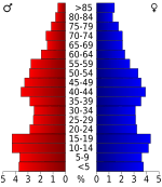
The population of Desha County has changed over time. You can see how it has grown and shrunk in the table above.
Population in 2020
| Race | Number of People | Percentage |
|---|---|---|
| White | 4,732 | 41.53% |
| Black or African American | 5,385 | 47.26% |
| Native American | 36 | 0.32% |
| Asian | 61 | 0.54% |
| Other/Mixed | 408 | 3.58% |
| Hispanic or Latino | 773 | 6.78% |
According to the 2020 United States Census, there were 11,395 people living in Desha County. These people lived in 5,204 households, and 3,545 of these were families.
Communities in Desha County
Desha County has several towns and cities where people live.
Cities
- Arkansas City (This is the county seat, where the main government offices are)
- Dumas
- McGehee
- Mitchellville
- Tillar (partly in Drew County)
- Watson
Towns
Unincorporated Areas
These are smaller communities that are not officially cities or towns:
Historic Community
Townships
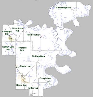
Townships are smaller divisions of a county. Here are the townships in Desha County: Townships in Arkansas are the divisions of a county. Each township includes unincorporated areas; some may have incorporated cities or towns within part of their boundaries. Arkansas townships have limited purposes in modern times. However, the United States Census does list Arkansas population based on townships (sometimes referred to as "county subdivisions" or "minor civil divisions"). Townships are also of value for historical purposes in terms of genealogical research. Each town or city is within one or more townships in an Arkansas county based on census maps and publications. The townships of Desha County are listed below; listed in parentheses are the cities, towns, and/or census-designated places that are fully or partially inside the township.
- Bowie (includes most of McGehee)
- Clayton (includes Reed, Tillar, and a small part of McGehee)
- Franklin (includes Arkansas City)
- Halley (includes a small part of McGehee)
- Jefferson
- Mississippi
- Randolph (includes Mitchellville and most of Dumas)
- Red Fork (includes Watson)
- Richland
- Silver Lake
- Walnut Lake
Notable People from Desha County
Many interesting people have come from Desha County, including:
- John "Kayo" Dottley
- Jim Hines
- John H. Johnson
- Major Jones
- Doug Terry
- Barry Williamson
See also
 In Spanish: Condado de Desha para niños
 | Leon Lynch |
 | Milton P. Webster |
 | Ferdinand Smith |


