Phillips County, Arkansas facts for kids
Quick facts for kids
Phillips County
|
|
|---|---|

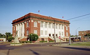
Phillips County courthouse in Helena-West Helena
|
|

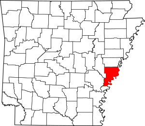
Location within the U.S. state of Arkansas
|
|
 Arkansas's location within the U.S. |
|
| Country | |
| State | |
| Founded | May 1, 1820 |
| Named for | Sylvanus Phillips |
| Seat | Helena-West Helena |
| Largest city | Helena-West Helena |
| Area | |
| • Total | 727 sq mi (1,880 km2) |
| • Land | 696 sq mi (1,800 km2) |
| • Water | 32 sq mi (80 km2) 4.4%% |
| Population
(2020)
|
|
| • Total | 16,568 |
| • Estimate
(2021)
|
15,906 |
| • Density | 22.790/sq mi (8.799/km2) |
| Time zone | UTC−6 (Central) |
| • Summer (DST) | UTC−5 (CDT) |
| Congressional district | 1st |
Phillips County is a county in eastern Arkansas. It's part of the Arkansas Delta, a flat area along the Mississippi River. In 2020, about 16,568 people lived here. The main city and county center is Helena–West Helena.
Phillips County was created on May 1, 1820. It was the seventh county in Arkansas. The county is named after Sylvanus Phillips. He was one of the first European-American settlers in the area. He was also elected to the first government of the Arkansas Territory. This area has rich soil and was used for growing cotton. It is still mostly a farming area today.
The city of Helena-West Helena and all of Phillips County are part of a larger statistical area.
Contents
History
A sad event happened in Phillips County from September 30 to October 1, 1919. This was during the Elaine race riot. Many African Americans were harmed by armed white groups. This happened because African American farmers were trying to organize a union to get fair pay for their crops.
Geography
Phillips County covers a total area of about 727 square miles (1,883 square kilometers). Most of this is land, about 696 square miles (1,803 square kilometers). The rest, about 32 square miles (83 square kilometers), is water.
Major Highways
Neighboring Counties
Phillips County shares borders with these other counties:
- Lee County (north)
- Tunica County, Mississippi (northeast)
- Coahoma County, Mississippi (east)
- Bolivar County, Mississippi (southeast)
- Desha County (south)
- Arkansas County (southwest)
- Monroe County (northwest)
Protected Natural Areas
Parts of these national protected areas are found in Phillips County:
Population Data
| Historical population | |||
|---|---|---|---|
| Census | Pop. | %± | |
| 1830 | 1,152 | — | |
| 1840 | 3,547 | 207.9% | |
| 1850 | 6,935 | 95.5% | |
| 1860 | 14,877 | 114.5% | |
| 1870 | 15,372 | 3.3% | |
| 1880 | 21,262 | 38.3% | |
| 1890 | 25,341 | 19.2% | |
| 1900 | 26,561 | 4.8% | |
| 1910 | 33,535 | 26.3% | |
| 1920 | 44,530 | 32.8% | |
| 1930 | 40,683 | −8.6% | |
| 1940 | 45,970 | 13.0% | |
| 1950 | 46,254 | 0.6% | |
| 1960 | 43,997 | −4.9% | |
| 1970 | 40,046 | −9.0% | |
| 1980 | 34,772 | −13.2% | |
| 1990 | 28,838 | −17.1% | |
| 2000 | 26,445 | −8.3% | |
| 2010 | 21,757 | −17.7% | |
| 2020 | 16,568 | −23.8% | |
| 2023 (est.) | 14,961 | −31.2% | |
| U.S. Decennial Census 1790–1960 1900–1990 1990–2000 2010–2021 |
|||
2020 Census Information
In 2020, the census showed that 16,568 people lived in Phillips County. There were 7,485 households and 4,836 families.
Here's a look at the different groups of people living in Phillips County in 2020:
| Race | Number | Percent |
|---|---|---|
| White | 5,541 | 33.44% |
| Black or African American | 10,305 | 62.2% |
| Native American | 38 | 0.23% |
| Asian | 64 | 0.39% |
| Pacific Islander | 4 | 0.02% |
| Other/Mixed | 352 | 2.12% |
| Hispanic or Latino | 264 | 1.59% |
2010 Census Information
According to the 2010 census, 21,757 people lived in the county.
- 63.1% were Black or African American.
- 35.0% were White.
- 0.3% were Asian.
- 0.2% were Native American.
- 0.4% were from some other race.
- 0.9% were of two or more races.
- About 1.3% of the people were Hispanic or Latino (of any race).
Education
Several school districts serve the students in Phillips County:
- Helena-West Helena School District
- Marvell–Elaine School District
- Barton–Lexa School District
In the past, some school districts merged to form the current ones. For example, the Lake View School District joined with the Barton–Lexa district in 2004. Also, the Elaine School District joined with the Marvell district in 2006.
There is also a private school called Marvell Academy. It was started in 1966 and is located near Marvell, in an unincorporated part of the county.
Communities
Cities
- Elaine
- Helena–West Helena (This is the county seat, meaning it's the main city for county government.)
- Lake View
- Marvell
Town
Unincorporated Places
These are places that are not officially part of a city or town:
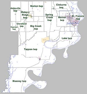
Townships
Phillips County is divided into smaller areas called townships. These are used for local administration. Townships in Arkansas are the divisions of a county. Each township includes unincorporated areas; some may have incorporated cities or towns within part of their boundaries. Arkansas townships have limited purposes in modern times. However, the United States Census does list Arkansas population based on townships (sometimes referred to as "county subdivisions" or "minor civil divisions"). Townships are also of value for historical purposes in terms of genealogical research. Each town or city is within one or more townships in an Arkansas county based on census maps and publications. The townships of Phillips County are listed below; listed in parentheses are the cities, towns, and/or census-designated places that are fully or partially inside the township.
Notable People
Many interesting people have come from Phillips County:
- Bruce Bennett, who was the Arkansas Attorney General.
- Barry Williamson, an attorney and a member of the Texas Railroad Commission.
- Blanche Lincoln, who served as a U.S. Senator.
- Mark Lavon "Levon" Helm, a famous drummer and singer for the band called The Band.
- Robert Lockwood Jr., a well-known blues guitarist and singer.
- Angie Craig, a U.S. Representative from Minnesota.
See also
 In Spanish: Condado de Phillips (Arkansas) para niños
 | James Van Der Zee |
 | Alma Thomas |
 | Ellis Wilson |
 | Margaret Taylor-Burroughs |


