Lee County, Arkansas facts for kids
Quick facts for kids
Lee County
|
|
|---|---|

Main façade of the Lee County Courthouse, 2014
|
|

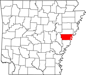
Location within the U.S. state of Arkansas
|
|
 Arkansas's location within the U.S. |
|
| Country | |
| State | |
| Founded | April 17, 1873 |
| Named for | General Robert E. Lee |
| Seat | Marianna |
| Largest city | Marianna |
| Area | |
| • Total | 620 sq mi (1,600 km2) |
| • Land | 603 sq mi (1,560 km2) |
| • Water | 17 sq mi (40 km2) 2.7%% |
| Population
(2020)
|
|
| • Total | 8,600 |
| • Density | 13.87/sq mi (5.36/km2) |
| Time zone | UTC−6 (Central) |
| • Summer (DST) | UTC−5 (CDT) |
| Congressional district | 1st |
Lee County is a county located in the state of Arkansas, USA. Its eastern border is along the Mississippi River. This makes it part of the Arkansas Delta, a flat region known for farming.
As of the 2020 census, about 8,600 people live in Lee County. The main town and county seat (where the county government is) is Marianna.
The state government created Lee County on April 17, 1873. This was during the Reconstruction era, a time after the American Civil War. The county was named after General Robert E. Lee. He was a famous general during the American Civil War.
Contents
History of Lee County
The Delta area, including Lee County, was mostly used for growing cotton. Before the American Civil War, enslaved African Americans did most of this farm work. Cotton remained a very important crop even into the 1900s. After slavery ended, many African Americans worked as sharecroppers or tenant farmers.
After the Reconstruction era, many white people tried to regain control. They used violence and fear to stop Black Republican voters. Around the year 1900, new state laws made it very hard for most Black people to vote. This lasted for many decades.
To escape this unfair treatment, thousands of African Americans moved away. This movement is known as the Great Migration. Many left Arkansas for cities in the North and West, especially after 1940.
Over time, new machines made farming easier. This meant fewer workers were needed on farms. Because of fewer job chances, the number of people living in Lee County has gone down. The population has decreased every ten years since 1940.
Geography of Lee County
Lee County covers a total area of about 620 square miles (1,600 square kilometers). Most of this area, about 603 square miles (1,560 square kilometers), is land. The remaining 17 square miles (44 square kilometers) is water. Water makes up about 2.7% of the county's total area.
Main Roads in Lee County
Neighboring Counties
Lee County shares borders with several other counties:
- St. Francis County (to the north)
- Crittenden County (to the northeast)
- Tunica County, Mississippi (to the east)
- Phillips County (to the south)
- Monroe County (to the west)
Protected Natural Areas
Part of the St. Francis National Forest is located within Lee County. This is a protected area of natural beauty.
Population and People
| Historical population | |||
|---|---|---|---|
| Census | Pop. | %± | |
| 1880 | 13,288 | — | |
| 1890 | 18,886 | 42.1% | |
| 1900 | 19,409 | 2.8% | |
| 1910 | 24,252 | 25.0% | |
| 1920 | 28,852 | 19.0% | |
| 1930 | 26,637 | −7.7% | |
| 1940 | 26,810 | 0.6% | |
| 1950 | 24,322 | −9.3% | |
| 1960 | 21,001 | −13.7% | |
| 1970 | 18,884 | −10.1% | |
| 1980 | 15,539 | −17.7% | |
| 1990 | 13,053 | −16.0% | |
| 2000 | 12,580 | −3.6% | |
| 2010 | 10,424 | −17.1% | |
| 2020 | 8,600 | −17.5% | |
| 2023 (est.) | 8,201 | −21.3% | |
| U.S. Decennial Census 1790–1960 1900–1990 1990–2000 2010 |
|||
2020 Census Information
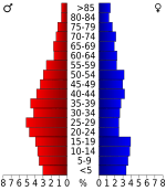
The 2020 United States Census counted 8,600 people living in Lee County. There were 3,206 households and 1,994 families.
The population was made up of different groups:
- About 39.81% of people were White.
- About 54.15% were Black or African American.
- A smaller number were Native American (0.21%), Asian (0.15%), or Pacific Islander (0.01%).
- About 3.15% were of other races or mixed races.
- About 2.51% were Hispanic or Latino (who can be of any race).
2010 Census Information
In the 2010 United States Census, there were 10,424 people in the county.
- About 55.3% were Black or African American.
- About 42.0% were White.
- About 0.5% were Native American.
- About 0.4% were Asian.
- About 1.6% were Hispanic or Latino (of any race).
- About 0.7% were of some other race.
- About 1.2% were of two or more races.
Towns and Communities
Lee County has several towns and smaller communities.
Towns in Lee County
Unincorporated Communities
These are smaller places that are not officially towns:
Townships
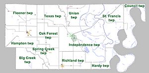
Counties in Arkansas are divided into smaller areas called townships. Here are the townships in Lee County: Townships in Arkansas are the divisions of a county. Each township includes unincorporated areas; some may have incorporated cities or towns within part of their boundaries. Arkansas townships have limited purposes in modern times. However, the United States Census does list Arkansas population based on townships (sometimes referred to as "county subdivisions" or "minor civil divisions"). Townships are also of value for historical purposes in terms of genealogical research. Each town or city is within one or more townships in an Arkansas county based on census maps and publications. The townships of Lee County are listed below; listed in parentheses are the cities, towns, and/or census-designated places that are fully or partially inside the township.
See also
 In Spanish: Condado de Lee (Arkansas) para niños
 | Janet Taylor Pickett |
 | Synthia Saint James |
 | Howardena Pindell |
 | Faith Ringgold |


