
Lambrook, Arkansas facts for kids
Quick facts for kids
Lambrook, Arkansas
|
|
|---|---|

Lambrook, Arkansas
Location in Arkansas

Lambrook, Arkansas
Location in the United States
|
|
| Country | United States |
| State | Arkansas |
| County | Phillips |
| Elevation | 161 ft (49 m) |
| Time zone | UTC-6 (Central (CST)) |
| • Summer (DST) | UTC-5 (CDT) |
| ZIP code |
72353
|
| Area code(s) | 870 |
| GNIS feature ID | 58044 |
Lambrook is a small, unincorporated community in Phillips County, Arkansas, in the United States. An unincorporated community is a place that doesn't have its own local government. Instead, it is part of a larger county.
Lambrook is located in the eastern part of Arkansas. It is about 7 miles (11 kilometers) west-northwest of a town called Elaine. You can find Lambrook along Arkansas Highway 20. This road helps people travel to and from the community.
Even though it's a small place, Lambrook has its own post office. The ZIP code for Lambrook is 72353. This means people living there can send and receive mail.
Images for kids
-
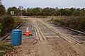
Warrens Bridge in Lambrook


All content from Kiddle encyclopedia articles (including the article images and facts) can be freely used under Attribution-ShareAlike license, unless stated otherwise. Cite this article:
Lambrook, Arkansas Facts for Kids. Kiddle Encyclopedia.