
Arkansas County, Arkansas facts for kids
Arkansas County is a county located in the state of Arkansas. In 2020, about 17,149 people lived here. It's found in a flat, fertile area called the Arkansas Delta. This county is special because it has two county seats: DeWitt and Stuttgart.
Quick facts for kids
Arkansas County
|
|
|---|---|

Clockwise from top: a rice field on the Grand Prairie, the Yancopin Bridge over the Arkansas River, the Southern District Courthouse in DeWitt, the Northern District Courthouse in Stuttgart, Arkansas
|
|

Location within the U.S. state of Arkansas
|
|
 Arkansas's location within the U.S. |
|
| Country | |
| State | |
| Founded | December 13, 1813 |
| Named for | Arkansas River |
| Seat | Stuttgart (north district); De Witt (south district) |
| Largest city | Stuttgart |
| Area | |
| • Total | 1,033.79 sq mi (2,677.5 km2) |
| • Land | 988.49 sq mi (2,560.2 km2) |
| • Water | 45.30 sq mi (117.3 km2) 4.4%% |
| Population
(2020)
|
|
| • Total | 17,149 |
| • Density | 16.5885/sq mi (6.40485/km2) |
| Time zone | UTC−6 (Central) |
| • Summer (DST) | UTC−5 (CDT) |
| Congressional district | 1st |
Arkansas County was the very first county created in Arkansas. It was formed on December 13, 1813. Back then, this area was part of the Missouri Territory. The county got its name from the Arkansas River. The river itself was named after the Arkansas tribe of Native Americans.
This county is one of only seven in the United States that shares its name with the state it's in!
Contents
History of Arkansas County
Early French and Spanish Times
Long ago, a place called Arkansas Post was a French fort. It was used for trading with Native American tribes, especially the Quapaw people. These tribes were friends with the French. However, some tribes, like the Chickasaw, were enemies. In 1749, Chickasaw warriors attacked Arkansas Post. They burned the settlement and took people captive. Because of this, the French moved the fort.
Later, after the French lost a war, the land went to Spain. But the Spanish didn't really control the area. French fur traders mostly stayed there. Then, Napoleon's French army took over Spain. Napoleon's brother, who became king of Spain, gave the Louisiana territory back to France.
The Louisiana Purchase and Becoming a Territory
The United States bought the huge Louisiana territory from France in 1803. This included the land that would become Arkansas County. The county was officially created on December 31, 1813. It was named after the Arkansas River and the Arkansas Native American tribe.
At first, Arkansas County was part of the Missouri Territory. But on March 2, 1819, the Arkansas Territory was created. Arkansas County became part of this new territory.
Statehood and Before the Civil War
The county seat, which is like the main government town, moved from Arkansas Post to DeWitt in 1853. This new town was chosen by the county leaders.
Before the Civil War, many large farms called plantations grew cotton in this area. Enslaved African Americans were forced to work on these plantations. The cotton crop made a lot of money for the plantation owners.
When the Civil War was about to start in 1861, most people in Arkansas County wanted to leave the United States and join the Confederate States.
Civil War and After
Arkansas County sent soldiers to fight in the Civil War. Companies like "The Crockett Rifles" and "The DeWitt Guards" were formed here.
After the Civil War, there were difficult times for African Americans in the county, and many faced unfair treatment. This led many to move away to other parts of the country. This movement was called the Great Migration. People left to find better opportunities and escape unfair treatment.
Geography of Arkansas County


Bottom: Rice field near Stuttgart
Arkansas County is mostly located in a flat area called the Arkansas Delta. This region is part of the Mississippi Alluvial Plain. It has very rich, fertile soil that was left behind by the Mississippi River over many years.
Most of Arkansas County is within a special part of the Delta called the Grand Prairie. This area used to be a large, flat grassland. Now, most of it is farmland. The main crop grown here is rice, but farmers also grow soybeans, cotton, corn, and wheat.
The rice fields are important for many kinds of waterfowl, like ducks and geese. This makes the county a popular spot for duck and goose hunting, especially since it's along the Mississippi Flyway, a major bird migration route.
The county also has beautiful forests along its rivers. Some of these forests are protected in places like the White River National Wildlife Refuge.
The county covers about 1,033.79 square miles (2,677.5 km2). About 988.49 square miles (2,560.2 km2) is land, and 45.30 square miles (117.3 km2) (4.4%) is water.
Arkansas County is about 55 miles (89 km) east of Little Rock. It is surrounded by other counties: Prairie County to the north, Monroe County to the northeast, Phillips County to the east, Desha County to the south, Lincoln County to the southwest, Jefferson County to the west, and Lonoke County to the northwest.
Rivers and Lakes

Water is very important to Arkansas County. Many rivers, streams, and ditches cross the area. People have lived along these waterways for thousands of years. The Arkansas River has always been important for travel and trade.
Three major rivers form much of the county's edges: the Arkansas River, Bayou Meto, and the White River. Inside the county, La Grue Bayou is another important waterway.
These rivers were also important during wars. There were battles fought here during the American Revolutionary War in 1783 (the Battle of Arkansas Post) and during the American Civil War in 1862 and 1863.
Protected Natural Areas
Several special areas in Arkansas County are protected for nature and recreation.
- The Dale Bumpers White River National Wildlife Refuge protects forests along the White River.
- The George H. Dunklin Jr. Bayou Meto Wildlife Management Area helps preserve woodlands and wetlands for wintering waterfowl.
- The Trusten Holder Wildlife Management Area is known for hunting, fishing, and watching bald eagles in winter.
- The Arkansas Natural Heritage Commission protects two small sites: the Roth Prairie Natural Area (a rare tallgrass prairie) and the Striplin Woods Natural Area (an old-growth forest).
The U.S. Army Corps of Engineers also manages campgrounds and day-use areas along the Arkansas River, offering places for camping, boating, and enjoying nature.

A very important historical site is Arkansas Post National Memorial. This was one of the first European settlements in the area, founded in 1686. It's a "ghost townsite" now, marking where old buildings used to be. Nearby, Arkansas Post State Park has a museum that tells the story of early settlers.
Population and People
The number of people living in Arkansas County was highest in 1940. Since then, fewer people have been needed for farm work because of new machines. This has caused many people to move away to find other jobs.
| Historical population | |||
|---|---|---|---|
| Census | Pop. | %± | |
| 1830 | 1,426 | — | |
| 1840 | 1,346 | −5.6% | |
| 1850 | 3,245 | 141.1% | |
| 1860 | 8,844 | 172.5% | |
| 1870 | 8,268 | −6.5% | |
| 1880 | 8,038 | −2.8% | |
| 1890 | 11,432 | 42.2% | |
| 1900 | 12,973 | 13.5% | |
| 1910 | 16,103 | 24.1% | |
| 1920 | 21,483 | 33.4% | |
| 1930 | 22,300 | 3.8% | |
| 1940 | 24,437 | 9.6% | |
| 1950 | 23,665 | −3.2% | |
| 1960 | 23,355 | −1.3% | |
| 1970 | 23,347 | 0.0% | |
| 1980 | 24,175 | 3.5% | |
| 1990 | 21,653 | −10.4% | |
| 2000 | 20,749 | −4.2% | |
| 2010 | 19,019 | −8.3% | |
| 2020 | 17,149 | −9.8% | |
| 2023 (est.) | 16,307 | −14.3% | |
| U.S. Decennial Census 1790–1960 1900–1990 1990–2000 2020 |
|||
Who Lives Here? (2020 Census)
| Race | Number | Percentage |
|---|---|---|
| White (non-Hispanic) | 11,575 | 67.5% |
| Black or African American (non-Hispanic) | 4,138 | 24.13% |
| Native American | 34 | 0.2% |
| Asian | 94 | 0.55% |
| Pacific Islander | 9 | 0.05% |
| Other/Mixed | 663 | 3.87% |
| Hispanic or Latino | 636 | 3.71% |
In 2020, there were 17,149 people living in Arkansas County. There were about 7,491 households (groups of people living together) and 4,723 families.
More About the People (2010 Census)
Racial/Ethnic Makeup of Arkansas County treating Hispanics as a Separate Category (2018) White Non-Hispanic (70.0%) Black Non-Hispanic (25.8%) Native American Non-Hispanic (0.1%) Asian Non-Hispanic (0.0%) Pacific Islander Non-Hispanic (0.0%) Other Non-Hispanic (0.0%) Two or more races Non-Hispanic (1.0%) Hispanic Any Race (3.1%)
In 2010, the county had 19,019 people. Most people were White (71.8%) or Black/African American (24.5%). About 2.7% of the population was Hispanic or Latino.
About 23.3% of the people were under 18 years old. The average age in the county was 40.7 years.
Education and Libraries
Schools

Most adults in Arkansas County have a high school degree. The county has two main public school districts:
- Stuttgart Public Schools
- DeWitt School District
Students in these districts graduate from Stuttgart High School or DeWitt High School. Both high schools offer advanced classes and are approved by the state's Department of Education.
Colleges
For higher education, there are two campuses of Phillips Community College in De Witt and Stuttgart. Other public colleges nearby include the University of Arkansas at Monticello and the University of Arkansas at Pine Bluff.
Libraries

The Arkansas County Library system has three branches:
- Cleon Collier Memorial Library
- DeWitt Public Library
- William F. Foster Stuttgart Public Library
These libraries offer books, e-books, movies, and help with research, youth programs, business, and family history.
Culture and Fun


Arkansas County has many places that help preserve its history and culture. You can visit:
- Arkansas Post State Park
- The Museum of the Grand Prairie in Stuttgart
- The Potlatch Conservation Education Center in Casscoe
- The Visitor Center at White River National Wildlife Refuge in St. Charles
Many historic buildings related to the county's rice farming history are listed on the National Register of Historic Places. These include old rice plantation pumps and rice dryer buildings.
The county also has two farmer's markets in Stuttgart and DeWitt. They sell fresh produce, baked goods, and crafts from May to October.
Yearly Events
- Gillett Coon Supper: This is a famous event in Gillett. It started in 1943 as a fundraiser for the local high school football team. People eat boiled and smoked raccoon. It's now a big gathering for local residents and politicians.
- Duck Hunting Season: This is perhaps the most popular event, happening from November to January. People from all over the country come to hunt ducks and geese. The season starts with the World's Championship Duck Calling Contest and Wings Over the Prairie Festival in Stuttgart.
- Arkansas County Fair: This fair has been held every year since 1938 in DeWitt, usually in mid-September.
Local News
The county newspaper is the Stuttgart Daily Leader, which has been published in Stuttgart since 1885.
Communities

Arkansas County has four cities and two towns that are officially recognized. Their populations have been getting smaller over the years.
- Stuttgart: This is the largest city and the northern county seat. In 2010, about 9,326 people lived here.
- DeWitt: This is the southern county seat and the second-largest city. In 2010, about 3,292 people lived here.
- Other smaller communities include Humphrey, St. Charles, Gillett, and Almyra.
Smaller Communities
Arkansas County also has many smaller, unincorporated communities and "ghost towns." These are places where people settled in small groups long ago, but they aren't officially recognized as cities or towns. Some might have had a post office at one time, while others are just a few homes at a crossroads.
- Arkansas Post
- Bayou Meto
- Benzal
- Burks
- Casscoe
- Crocketts Bluff
- Deluce
- Ethel
- Goldman
- Hagler
- Holdridge
- Hortons Landing
- Hyden
- Immanuel
- Jacks Bay Landing
- Kittlers
- La Grue Springs
- LaGrue
- Lodge Corner
- Lookout
- Mayview
- Medina
- Mount Adams
- Nady
- North Stuttgart
- Olena
- Plainview
- Prairie Landing
- Prairie Union
- Preston Ferry
- Ricusky
- Sheppard Point
- South Stuttgart
- Tichnor
- Vallier
- Van
- Weber
- Yoder
Historical Communities
- Abeles
- Arkansas
- Buffo
- Fish Dock
- Monica
- Ona
- Osotouy
- Parham
- Roberts
- Sassafras
- Super
- Thomwall
- West Bayou
Townships

Counties in Arkansas are divided into smaller areas called townships. Here are the townships in Arkansas County: Townships in Arkansas are the divisions of a county. Each township includes unincorporated areas; some may have incorporated cities or towns within part of their boundaries. Arkansas townships have limited purposes in modern times. However, the United States Census does list Arkansas population based on townships (sometimes referred to as "county subdivisions" or "minor civil divisions"). Townships are also of value for historical purposes in terms of genealogical research. Each town or city is within one or more townships in an Arkansas county based on census maps and publications. The townships of Arkansas County are listed below; listed in parentheses are the cities, towns, and/or census-designated places that are fully or partially inside the township.
Transportation
Airports

Arkansas County has two public airports: Almyra Municipal Airport and DeWitt Municipal Airport. These are small airports mostly used for agricultural planes, like those that spray crops. Stuttgart Municipal Airport is just north of Stuttgart, in Prairie County.
Main Roads
 US Route 63
 US Route 79
 US Route 165
 Highway 1
 Highway 11
 Highway 17
 Highway 33
 Highway 44
 Highway 130
 Highway 144
 Highway 146
 Highway 152
 Highway 153
 Highway 169
 Highway 276
 Highway 343
 Highway 980
Images for kids
-
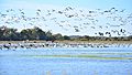
Waterfowl near Bayou Meto

See also
 In Spanish: Condado de Arkansas para niños
