Mississippi Alluvial Plain facts for kids
The Mississippi River Alluvial Plain is a huge, flat area of land. It was formed by the Mississippi River over thousands of years. Think of it like a giant fan-shaped pile of soil and rocks. This happens when a fast river slows down and spreads out, dropping all the dirt it carried.
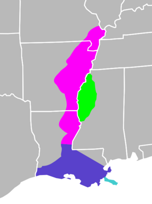
This amazing plain covers parts of seven U.S. states. These states stretch from southern Louisiana all the way up to southern Illinois. The states included are Illinois, Missouri, Kentucky, Tennessee, Arkansas, Mississippi, and Louisiana.
Exploring the Mississippi River Alluvial Plain
The Mississippi River Alluvial Plain is divided into two main parts. One part is the Mississippi River Delta, found in the southern half of Louisiana. The other part is the upper Mississippi Embayment. This embayment runs from central Louisiana up to Illinois.
What is the Mississippi Embayment?
The term "Mississippi Embayment" can sometimes be used in a more specific way. It often refers to the part of the plain on the western side of the river. This section goes through eastern Arkansas, southeastern Missouri, westernmost Tennessee, westernmost Kentucky, and southernmost Illinois.
It usually does not include northwest Mississippi. That area is a special part of the alluvial plain known as the Mississippi Delta.
Louisiana's Largest Ecoregion
This plain is the biggest ecoregion in the state of Louisiana. An ecoregion is a large area of land or water that has a distinct climate, geology, and plant and animal life. The Mississippi River Alluvial Plain covers about 12,350 square miles (32,000 square kilometers) in Louisiana. It includes all the land that the Mississippi River used to flood regularly.
 | Sharif Bey |
 | Hale Woodruff |
 | Richmond Barthé |
 | Purvis Young |


