Chicot County, Arkansas facts for kids
Quick facts for kids
Chicot County
|
|
|---|---|

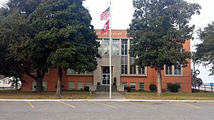
Chicot County Courthouse in Lake Village
|
|

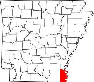
Location within the U.S. state of Arkansas
|
|
 Arkansas's location within the U.S. |
|
| Country | |
| State | |
| Founded | October 25, 1823 |
| Seat | Lake Village |
| Largest city | Dermott |
| Area | |
| • Total | 691 sq mi (1,790 km2) |
| • Land | 644 sq mi (1,670 km2) |
| • Water | 47 sq mi (120 km2) 6.7%% |
| Population
(2020)
|
|
| • Total | 10,208 |
| • Estimate
(2023)
|
9,538 |
| • Density | 14.773/sq mi (5.704/km2) |
| Time zone | UTC−6 (Central) |
| • Summer (DST) | UTC−5 (CDT) |
| Congressional district | 1st |
Chicot County is a county located in the southeastern part of Arkansas. As of 2020, about 10,208 people live there. The main town and county seat is Lake Village.
Chicot County was created on October 25, 1823. It was named after Point Chicot, a spot on the Mississippi River. This area is part of the Arkansas Delta, which is a flat region along the river. It was historically important for growing large amounts of cotton.
Some cool places in Chicot County include Lake Chicot. This is North America's largest oxbow lake and Arkansas's biggest natural lake. You can also find the place where Charles Lindbergh made his first night-time flight. Near Lake Village, there's a legendary burial site of the explorer Hernando De Soto.
Contents
History of Chicot County
The Spanish explorer Hernando de Soto visited this area in 1542. His group stayed for a while in a village called Guachoya. Much later, in the 1800s, the town of Lake Village grew up near Lake Chicot. This lake was formed from a bend in the Mississippi River.
French settlers in the 1700s named the area Chicot. This name came from the many cypress trees in the waterways. The word "chicot" means "stumpy" or "knobby" in French.
Cotton Plantations and Enslaved People
The land along the Mississippi River was used for large cotton farms called plantations. Cotton was a very important crop before and after the American Civil War (1861–1865). Many African Americans were forced to work on these farms as enslaved people. They made up most of the population before the war.
Some of the big cotton plantations included Sunnyside, Florence, Patria, Pastoria, Luna, and Lakeport.
Civil War Events
During the Civil War, there were battles in Chicot County. On February 14, 1864, 13 Black Union soldiers were attacked and killed. This happened near Ross's Landing at the Tecumseh plantation. Union and Confederate forces also fought at the Battle of Old River Lake on June 5 and 6, 1864.
Population Changes Over Time
The number of people living in Chicot County has gone down since 1940. In the early 1900s, tiny insects called boll weevils damaged the cotton crops. Also, many African Americans moved away during the Great Migration. They went to cities in the North and Midwest to find better jobs and opportunities.
Over time, farming also changed. Machines started doing more of the work, and farms became larger. This meant fewer people were needed to work on the land.
Geography of Chicot County
Chicot County covers about 691 square miles. Most of this area, about 644 square miles, is land. The rest, about 47 square miles, is water. This means about 6.7% of the county is water.
Main Roads in Chicot County
 U.S. Highway 65
 U.S. Highway 82
 U.S. Highway 165
 U.S. Highway 278
 Highway 8
 Highway 35
 Highway 159
 Highway 52
- Arkansas 144
Counties Next to Chicot County
- Desha County (north)
- Bolivar County, Mississippi (northeast)
- Washington County, Mississippi (east)
- Issaquena County, Mississippi (southeast)
- East Carroll Parish, Louisiana (south)
- West Carroll Parish, Louisiana (south)
- Morehouse Parish, Louisiana (southwest)
- Ashley County (west)
- Drew County (northwest)
People of Chicot County
| Historical population | |||
|---|---|---|---|
| Census | Pop. | %± | |
| 1830 | 1,165 | — | |
| 1840 | 3,806 | 226.7% | |
| 1850 | 5,115 | 34.4% | |
| 1860 | 9,234 | 80.5% | |
| 1870 | 7,214 | −21.9% | |
| 1880 | 10,117 | 40.2% | |
| 1890 | 11,419 | 12.9% | |
| 1900 | 14,528 | 27.2% | |
| 1910 | 21,987 | 51.3% | |
| 1920 | 21,749 | −1.1% | |
| 1930 | 22,646 | 4.1% | |
| 1940 | 27,452 | 21.2% | |
| 1950 | 22,306 | −18.7% | |
| 1960 | 18,990 | −14.9% | |
| 1970 | 18,164 | −4.3% | |
| 1980 | 17,793 | −2.0% | |
| 1990 | 15,713 | −11.7% | |
| 2000 | 14,117 | −10.2% | |
| 2010 | 11,800 | −16.4% | |
| 2020 | 10,208 | −13.5% | |
| 2023 (est.) | 9,538 | −19.2% | |
| U.S. Decennial Census 1790–1960 1900–1990 1990–2000 2010 |
|||
What the 2020 Census Shows
In 2020, there were 10,208 people living in Chicot County. There were 4,068 households and 2,636 families.
| Race | Number of People | Percentage |
|---|---|---|
| White | 3,887 | 38.08% |
| Black or African American | 5,387 | 52.77% |
| Native American | 26 | 0.25% |
| Asian | 38 | 0.37% |
| Pacific Islander | 9 | 0.09% |
| Other/Mixed | 280 | 2.74% |
| Hispanic or Latino | 581 | 5.69% |
What the 2010 Census Showed
In 2010, there were 11,800 people in the county. About 54.1% were Black or African American. Around 41.2% were White. A small number were Asian (0.5%) or Native American (0.2%). About 3.2% were of another race, and 0.8% were of two or more races. About 4.6% of the people were Hispanic or Latino.
Communities in Chicot County
Cities in Chicot County
- Dermott
- Eudora
- Lake Village (This is the county seat)
Small Towns and Areas Without City Government
- Arkla
- Bellaire
- Cosgrove
- Chicot Junction
- Empire
- Farmwood
- Indian
- Grand Lake
- Hudspeth
- Jennie
- Lakeport
- Lakehall
- Luna
- McMillian Corner
- Readland
- Ross Van Ness
- Shives
- Stuart Island
- Wellford
Old Towns That No Longer Exist
- Columbia
- Eunice
- Gaines Landing
Areas Called Townships
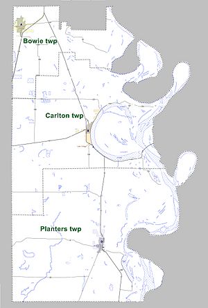
Chicot County is divided into three main areas called townships:
- Bowie (includes Dermott)
- Carlton (includes Lake Village)
- Planters (includes Eudora)
Famous People from Chicot County
- Larry D. Alexander - An artist, writer, and Bible teacher.
- Jim Cain - An American football player.
- Ruby Grant Martin - A lawyer and government official who worked for civil rights.
- Robert L. Hill - He started the Progressive Farmers and Household Union of America.
- Mark D. McElroy - A state representative for Chicot County.
- Lycurgus Johnson - He owned the Lakeport Plantation and later became a state congressman.
Images for kids
See also
 In Spanish: Condado de Chicot para niños
 | Toni Morrison |
 | Barack Obama |
 | Martin Luther King Jr. |
 | Ralph Bunche |


