Issaquena County, Mississippi facts for kids
Quick facts for kids
Issaquena County
|
|
|---|---|

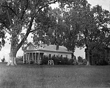
Historic photo of the Issaquena County Courthouse in Mayersville, Mississippi
|
|

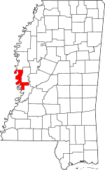
Location within the U.S. state of Mississippi
|
|
 Mississippi's location within the U.S. |
|
| Country | |
| State | |
| Founded | January 23, 1844 |
| Seat | Mayersville |
| Largest town | Mayersville |
| Area | |
| • Total | 441 sq mi (1,140 km2) |
| • Land | 413 sq mi (1,070 km2) |
| • Water | 28 sq mi (70 km2) 6.4% |
| Population
(2020)
|
|
| • Total | 1,338 |
| • Estimate
(2022)
|
1,273 |
| • Density | 3.034/sq mi (1.1714/km2) |
| Time zone | UTC−6 (Central) |
| • Summer (DST) | UTC−5 (CDT) |
| Congressional district | 2nd |
Issaquena County (/ˌɪsəˈkwiːnə/, ISS-ə-KWEEN-ə) is a county located in the U.S. state of Mississippi. In 2020, only 1,338 people lived there. This makes it the county with the fewest people east of the Mississippi River in the entire United States! Its main town, or county seat, is Mayersville. Issaquena County is also known as one of the poorest counties in the United States.
This county is found in the Mississippi Delta region. The mighty Mississippi River flows along its entire western side. Many of the first towns here were busy river ports.
The county's economy mostly depends on farming and a prison called the Issaquena County Correctional Facility. Hunting is also important. Mississippi's largest alligators caught by hunters have been found in Issaquena County. In 2012, a huge 697.5 lb (316.4 kg) alligator was caught near Fitler.
Contents
Discovering Issaquena County's Past
The name "Issaquena" comes from the Choctaw language. It means "Deer River" and is the original name for Deer Creek. The Choctaw people were the first to live in this area. They were moved from their land in 1820. New settlers, who were not Native Americans, started arriving in the early 1830s.
How Issaquena County Was Formed
Issaquena County was officially created on January 23, 1844. It was made from the southern part of Washington County. The first county seat was in a place called Skipwith. Later, it moved to Duncansby. Both of these places are now "ghost towns," meaning no one lives there anymore. In 1848, the county seat moved to Tallula. Finally, in 1871, it moved to Mayersville, where it is today.
The county is entirely within the Mississippi Alluvial Plain. This area has rich, dark soil and thick hardwood forests. Early settlers cleared many of these forests. By the early 1890s, about 50,000 acres (20,000 ha) of the county was used to grow crops like corn, cotton, and oats. Around the same time, a railroad called the Louisville, New Orleans and Texas Railway was built through the middle of the county.
In 1876, Sharkey County was created. It took parts of Issaquena, Warren, and Washington counties.
Slavery in Issaquena County
In 1860, a very large number of people in Issaquena County were enslaved. About 92.5% of the population were enslaved people. This was the highest percentage in the entire United States. The U.S. Census from that year showed that 7,244 enslaved people lived in Issaquena County. Many slave owners had very large numbers of enslaved people. For example, Stephen Duncan held 858 enslaved people.
After slavery was ended, the county changed. By 1880, just 15 years later, people were paid for their work. Issaquena was the only county in Mississippi where people did not share crops or rent land for farming.
The Civil War and Issaquena County
During the American Civil War, Union Army General Ulysses S. Grant tried to capture Vicksburg. This was a strong Confederate fort south of Issaquena County. He tried to attack it by water in 1862 and 1863.
One of these attacks was called the Steele's Bayou Expedition. It happened on waterways inside Issaquena County. These included Steele Bayou, the Little Sunflower River, the Big Sunflower River, Deer Creek, Black Bayou, Little Black Bayou, and the Yazoo River.
The Union boats were large and found it hard to move in the shallow waterways. Also, the Confederate defenses were very strong. The Steele's Bayou Expedition was a defeat for the Union forces in Issaquena County.
Major Weather Events
In 1971, a very large tornado moved through Issaquena County. It caused a lot of damage and destroyed several towns.
Geography and Location
According to the United States Census Bureau, Issaquena County covers a total area of 441 square miles (1,140 km2). About 413 square miles (1,070 km2) of this is land, and 28 square miles (73 km2) (6.4%) is water.
Main Roads in Issaquena County
Neighboring Counties
Issaquena County shares borders with these other counties:
- Washington County (north)
- Sharkey County (northeast)
- Yazoo County (east)
- Warren County (south)
- East Carroll Parish, Louisiana (west)
- Chicot County, Arkansas (northwest)
People of Issaquena County
| Historical population | |||
|---|---|---|---|
| Census | Pop. | %± | |
| 1850 | 4,478 | — | |
| 1860 | 7,831 | 74.9% | |
| 1870 | 6,887 | −12.1% | |
| 1880 | 10,004 | 45.3% | |
| 1890 | 12,318 | 23.1% | |
| 1900 | 10,400 | −15.6% | |
| 1910 | 10,560 | 1.5% | |
| 1920 | 7,618 | −27.9% | |
| 1930 | 5,734 | −24.7% | |
| 1940 | 6,433 | 12.2% | |
| 1950 | 4,966 | −22.8% | |
| 1960 | 3,576 | −28.0% | |
| 1970 | 2,737 | −23.5% | |
| 1980 | 2,513 | −8.2% | |
| 1990 | 1,909 | −24.0% | |
| 2000 | 2,274 | 19.1% | |
| 2010 | 1,406 | −38.2% | |
| 2020 | 1,338 | −4.8% | |
| 2023 (est.) | 1,256 | −10.7% | |
| U.S. Decennial Census 1790-1960 1900-1990 1990-2000 2010-2020 |
|||
Population in 2020
In 2020, there were 1,338 people living in Issaquena County.
| Race | Number | Percent |
|---|---|---|
| Black or African American | 748 | 55.9% |
| White | 440 | 32.88% |
| Hispanic or Latino | 128 | 9.57% |
| Other/Mixed | 16 | 1.2% |
| Asian | 5 | 0.37% |
| Native American | 1 | 0.07% |
Population in 2010
In 2010, there were 1,406 people living in the county. Most of the people (64.4%) were Black or African American. About 34.6% were White. A small number were Asian, Native American, or of two or more races.
Poverty and Jobs
In 2011, Issaquena County had one of the highest rates of poverty in the United States. About 40.1% of the people living there were in poverty. For children under 18, the poverty rate was even higher.
In 2014, Issaquena County also had the highest percentage of people without jobs in Mississippi. It was the fifth highest in the entire United States.
Learning and Education
There are no schools located directly in Issaquena County. Students from the county go to schools in nearby Sharkey and Washington counties.
Public Schools
- South Delta School District – This district is based in Rolling Fork. It serves most of Issaquena County, including Mayersville. It operates South Delta High School.
- Western Line School District – This district is based in Avon. It serves the northwestern part of Issaquena County.
Private Schools
- Sharkey-Issaquena Academy – This school is in Rolling Fork. Students from Issaquena County can attend this school.
Before the 1970s, when schools were separated by race, Issaquena County only had schools for Black students.
Communities in Issaquena County
Town
Census-Designated Places
These are areas that are like towns but are not officially incorporated.
- Grace
- Valley Park
Unincorporated Communities
These are smaller communities that are not officially part of a town.
Ghost Towns
These are places where people used to live, but now no one does.
- Arcadia
- Baleshed
- Ben Lomond
- Duncansby
- Magna Vista
- Shiloh
- Skipwith's Landing
Famous People from Issaquena County
- Unita Blackwell: A leader in the Civil Rights movement. She was the mayor of Mayersville from 1976 to 2001. She was the first African-American woman mayor in Mississippi.
- Charles C. Diggs, Sr.: The first African-American Democrat elected to the Michigan Senate. He was born in Tallula.
- William Stamps Farish II: He was the president of Standard Oil. He was born in Mayersville.
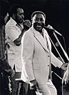
- Muddy Waters: A very famous blues musician (1913–1983). He was born in a place called "Jug's Corner."
- Eliza Winston: A notable enslaved person.
See also
 In Spanish: Condado de Issaquena (Misisipi) para niños
 | William Lucy |
 | Charles Hayes |
 | Cleveland Robinson |


