Yazoo County, Mississippi facts for kids
Quick facts for kids
Yazoo County
|
|
|---|---|

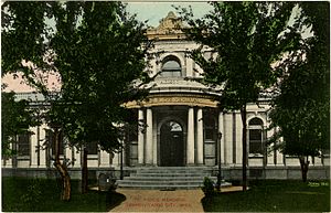
Postcard. Ricks Memorial Library in Yazoo City.
|
|

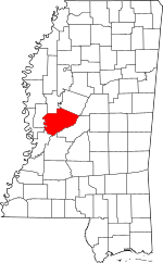
Location within the U.S. state of Mississippi
|
|
 Mississippi's location within the U.S. |
|
| Country | |
| State | |
| Founded | January 21, 1823 |
| Named for | Yazoo River |
| Seat | Yazoo City |
| Largest city | Yazoo City |
| Area | |
| • Total | 934 sq mi (2,420 km2) |
| • Land | 923 sq mi (2,390 km2) |
| • Water | 11 sq mi (30 km2) 1.2% |
| Population
(2020)
|
|
| • Total | 26,743 |
| • Density | 28.633/sq mi (11.055/km2) |
| Time zone | UTC−6 (Central) |
| • Summer (DST) | UTC−5 (CDT) |
| ZIP Codes |
39039, 39040, 39088, 39095, 39146, 39162, 39179, 39194
|
| Area code | 662 |
| Congressional district | 2nd |
Yazoo County is a county in the state of Mississippi. In 2020, about 26,743 people lived there. The main town, or county seat, is Yazoo City. The county gets its name from the Yazoo River, which runs along its western side. The name "Yazoo" might come from a Choctaw language word meaning "River of Death."
Contents
Discovering Yazoo County's Past
The land that is now Yazoo County was once home to the Choctaw Native American people. Mississippi acquired this land in 1820. Yazoo County was officially created on January 21, 1823. It was the 19th county formed in Mississippi and is still the largest in terms of land area.
The first county seat was at Beatties Bluff. A county seat is the town where the county government offices are located. In 1829, the county seat moved to Benton. Then, in 1849, it moved again to Yazoo City, where it remains today.
Yazoo County saw battles during the American Civil War in 1863 and 1864. A famous train accident involving engineer Casey Jones happened here in 1900. It took place just north of Vaughan. The Great Mississippi Flood of 1927 also caused a lot of damage in Yazoo County.
Exploring Yazoo County's Geography
Yazoo County covers a total area of 934 square miles. Most of this is land, about 923 square miles. The rest, about 11 square miles, is water. This makes it the largest county in Mississippi by land area. It is the third-largest by total area.
Neighboring Counties Around Yazoo
Yazoo County shares borders with several other counties:
- Humphreys County (to the north)
- Holmes County (to the northeast)
- Madison County (to the east)
- Hinds County (to the south)
- Warren County (to the southwest)
- Issaquena County (to the west)
- Sharkey County (to the northwest)
Protected Natural Areas
Yazoo County is home to parts of two important national wildlife refuges. These areas protect natural habitats for animals and plants:
Understanding Yazoo County's Population
| Historical population | |||
|---|---|---|---|
| Census | Pop. | %± | |
| 1830 | 6,550 | — | |
| 1840 | 10,480 | 60.0% | |
| 1850 | 14,418 | 37.6% | |
| 1860 | 22,373 | 55.2% | |
| 1870 | 17,279 | −22.8% | |
| 1880 | 33,845 | 95.9% | |
| 1890 | 36,394 | 7.5% | |
| 1900 | 43,948 | 20.8% | |
| 1910 | 46,672 | 6.2% | |
| 1920 | 37,149 | −20.4% | |
| 1930 | 37,262 | 0.3% | |
| 1940 | 40,091 | 7.6% | |
| 1950 | 35,712 | −10.9% | |
| 1960 | 31,653 | −11.4% | |
| 1970 | 27,304 | −13.7% | |
| 1980 | 27,349 | 0.2% | |
| 1990 | 25,506 | −6.7% | |
| 2000 | 28,149 | 10.4% | |
| 2010 | 28,065 | −0.3% | |
| 2020 | 26,743 | −4.7% | |
| 2023 (est.) | 25,796 | −8.1% | |
| U.S. Decennial Census 1790–1960 1900–1990 1990–2000 2010-2013 |
|||
Population in 2020
In 2020, the United States Census counted 26,743 people living in Yazoo County. There were 8,542 households and 5,203 families.
| Race | Num. | Perc. |
|---|---|---|
| White | 9,184 | 34.34% |
| Black or African American | 15,812 | 59.13% |
| Native American | 50 | 0.19% |
| Asian | 115 | 0.43% |
| Pacific Islander | 6 | 0.02% |
| Other/Mixed | 500 | 1.87% |
| Hispanic or Latino | 1,076 | 4.02% |
Population in 2010
According to the 2010 United States Census, there were 28,065 people in the county. About 57.1% were Black or African American. Around 40.0% were White. Other groups included 0.4% Asian, 0.3% Native American, and 0.7% of some other race. About 1.5% of people identified as two or more races. Also, 4.6% of the population was Hispanic or Latino.
Getting Around Yazoo County
Main Roads
Several important highways pass through Yazoo County, making it easy to travel:
 Interstate 55
 U.S. Highway 49
 U.S. Highway 49W
 U.S. Highway 49E
 Mississippi Highway 3
 Mississippi Highway 16
 Mississippi Highway 149
 Mississippi Highway 433
Airport Access
The Yazoo County Airport is located in an area without a city government, about 2 miles (3.2 km) west of central Yazoo City.
Learning in Yazoo County
Yazoo County has different schools for its students.
Public School Districts
- Yazoo City Municipal School District: This district serves students living within the Yazoo City limits. Its high school is Yazoo City High School.
- Yazoo County School District: This district serves students who live outside the Yazoo City limits. Its high school is Yazoo County High School.
Private Schools
- Benton Academy (located in Benton)
- Manchester Academy (located in Yazoo City)
- Covenant Christian School (located in Yazoo City)
- Thomas Christian Academy (located in Yazoo City)
Communities in Yazoo County
Cities
- Yazoo City (This is the county seat, where the main government offices are.)
Towns
Villages
Unincorporated Communities
These are smaller communities that are not officially part of a city or town.
Ghost Towns
These are places where towns once existed but are now mostly abandoned.
Famous People from Yazoo County
- Haley Barbour: A former Governor of Mississippi.
- Willie Brown: A well-known football player.
- Jerry Clower: A famous comedian.
- Henry Espy: A former Mayor of Clarksdale, Mississippi.
- Mike Espy: A former U.S. Secretary of Agriculture.
- Lawrence Gordon: A movie producer.
- Lynn Hamilton: An actress.
- Jesse E. Holmes: A minister and community leader.
- Duck Holmes: A blues musician.
- T. J. Huddleston: An entrepreneur.
- Skip James: A blues musician.
- Tommy McClennan: A blues musician.
- Willie Morris: A writer.
- Stella Stevens: An actress.
- Zig Ziglar: A writer and motivational speaker.
See also
 In Spanish: Condado de Yazoo (Misisipi) para niños
 | Lonnie Johnson |
 | Granville Woods |
 | Lewis Howard Latimer |
 | James West |


