Wayside, Mississippi facts for kids
Quick facts for kids
Wayside, Mississippi
|
|
|---|---|

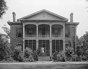
Belmont Plantation in Wayside is listed on the National Register of Historic Places
|
|
| Country | United States |
| State | Mississippi |
| County | Washington |
| Elevation | 121 ft (37 m) |
| Time zone | UTC-6 (Central (CST)) |
| • Summer (DST) | UTC-5 (CDT) |
| ZIP code |
38780
|
| Area code(s) | 662 |
| GNIS feature ID | 679401 |
Wayside is a small community in Washington County, Mississippi, United States. It's called an "unincorporated community" because it doesn't have its own local government like a city or town. Instead, it's part of the larger county. Wayside has a post office and a water tower. You can find it on Mississippi Highway 1, about 8 miles (13 km) south of a bigger city called Greenville.
A Look Back in Time
Early Days and the Belmont Plantation
One important place in Wayside's history is the Belmont Plantation. The main house was finished in 1859. It's special because it was one of the few large homes in the area that wasn't burned down during the American Civil War. Today, this historic home is listed on the National Register of Historic Places. This means it's recognized as an important historical site.
Wayside was once located right on the Mississippi River. It had a special landing where steamboats could stop. But in 1858, a big flood changed the river's path. This created a curved lake, now called Lake Lee, and moved the river away from Wayside.
Growth and Changes
In the late 1880s, a new railway line, part of the Louisville, New Orleans and Texas Railway, was built through Wayside. This helped the community connect with other places. By 1900, about 65 people lived in Wayside.
Recent Events
On October 9, 2009, a strong tornado hit Wayside. It sadly destroyed three mobile homes and damaged 16 other houses. Many trees were also knocked down. One person lost their life during the storm, and two others were hurt.
 | Calvin Brent |
 | Walter T. Bailey |
 | Martha Cassell Thompson |
 | Alberta Jeannette Cassell |


