Des Allemands, Louisiana facts for kids
Quick facts for kids
Des Allemands, Louisiana
"The Germans"
|
|
|---|---|

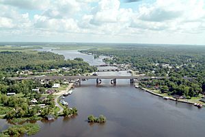
Des Allemands on the Bayou des Allemands. View to the north.
|
|
| Nickname(s):
"Catfish Capital of the Universe"
|
|
| Country | United States |
| State | Louisiana |
| Parishes | Lafourche, St. Charles |
| Area | |
| • Total | 12.23 sq mi (31.69 km2) |
| • Land | 9.95 sq mi (25.77 km2) |
| • Water | 2.29 sq mi (5.92 km2) |
| Elevation | 3 ft (0.9 m) |
| Population
(2020)
|
|
| • Total | 2,179 |
| • Density | 219.02/sq mi (84.56/km2) |
| Time zone | UTC-6 (CST) |
| • Summer (DST) | UTC-5 (CDT) |
| ZIP Code |
70030
|
| Area code(s) | 985 |
| FIPS code | 22-20680 |
Des Allemands is a community in southeastern Louisiana, USA. It is often called the "Catfish Capital of the Universe"! This town is located along the Bayou des Allemands. This bayou forms the border between Lafourche and St. Charles parishes.
In 2020, about 2,179 people lived here. The nearby Lac des Allemands is to the northwest. The ZIP Code for Des Allemands is 70030. Part of Des Allemands is near New Orleans, and another part is near Houma.
Contents
History of Des Allemands
The name Des Allemands means "of the Germans" in French. This name comes from the early settlers of the area.
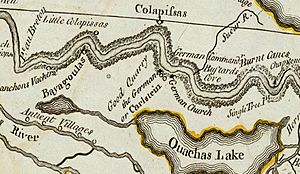
In 1721, a group of Germans settled along the Mississippi River. This was north of what is now Lake Salvador. This area was known as les Allemands (the Germans) or Karlstein. This "German Coast" was in today's St. Charles and St. John the Baptist Parishes.
The German colonists first tried to settle further up the Mississippi River. However, they faced problems with Native Americans there. So, they moved closer to New Orleans, which was the main colonial city.
Geography of Des Allemands
Des Allemands is located in southern St. Charles Parish and northeastern Lafourche Parish. It is at 29°49′32″N 90°28′9″W / 29.82556°N 90.46917°W. To the north is the community of Paradis. To the southeast is Bayou Gauche.
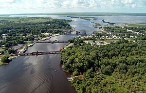
U.S. Route 90 is a major highway that crosses Bayou des Allemands here. This highway will become Interstate 49 in the future. It goes northeast about 34 miles (55 km) to New Orleans. It also goes west about 51 miles (82 km) to Morgan City.
The Bayou Des Allemands flows northwest about 5 miles (8 km) to Lac des Allemands. It also flows southeast about 13 miles (21 km) to Lake Salvador.
The total area of Des Allemands is about 12.23 square miles (31.7 square kilometers). Most of this area is land, about 9.95 square miles (25.8 square kilometers). The rest, about 2.29 square miles (5.9 square kilometers), is water.
Population and People
| Historical population | |||
|---|---|---|---|
| Census | Pop. | %± | |
| 2020 | 2,179 | — | |
| U.S. Decennial Census | |||
In 2020, there were 2,179 people living in Des Allemands. There were 670 households and 468 families.
Here's a look at the different groups of people living in Des Allemands in 2020:
| Race | Number | Percentage |
|---|---|---|
| White (not Hispanic or Latino) | 1,700 | 78.02% |
| Black or African American (not Hispanic or Latino) | 296 | 13.58% |
| Native American | 23 | 1.06% |
| Asian | 4 | 0.18% |
| Other/Mixed (two or more races) | 84 | 3.85% |
| Hispanic or Latino | 72 | 3.3% |
Schools and Education
Students in Des Allemands attend different schools depending on which side of Bayou Des Allemands they live on.
St. Charles Parish Schools
The St. Charles Parish Public School System serves the parts of Des Allemands east of the bayou.
- Allemands Elementary School in Des Allemands teaches students from pre-kindergarten to 2nd grade.
- R.J. Vial Elementary School in Paradis serves grades 3–5. This school opened in 1975.
- J. B. Martin Middle School in Paradis serves grades 6–8.
- Hahnville High School in Boutte serves grades 9–12.
Lafourche Parish Schools
Students living west of Bayou Des Allemands go to Lafourche Parish Public Schools.
- Raceland Lower Elementary School in Raceland
- Raceland Upper Elementary School in Raceland
- Raceland Middle School in Raceland
- Central Lafourche High School in Mathews
Colleges
Both Fletcher Technical Community College and Delgado Community College serve the Lafourche Parish area.
Local Festivals
Des Allemands hosts fun events throughout the year:
- Louisiana Catfish Festival: This festival takes place on the third weekend in June. It celebrates the town's nickname as the "Catfish Capital of the Universe."
- Mardi Gras Parade: A small parade is held during the Mardi Gras season.
See also
 In Spanish: Des Allemands para niños
 | Laphonza Butler |
 | Daisy Bates |
 | Elizabeth Piper Ensley |


