
Lafourche Parish, Louisiana facts for kids
Quick facts for kids
Lafourche Parish
|
|
|---|---|

Lafourche Parish Courthouse
|
|

Location within the U.S. state of Louisiana
|
|
 Louisiana's location within the U.S. |
|
| Country | |
| State | |
| Founded | 1807 |
| Named for | la fourche, French for the fork |
| Seat | Thibodaux |
| Largest city | Thibodaux |
| Area | |
| • Total | 1,474 sq mi (3,820 km2) |
| • Land | 1,068 sq mi (2,770 km2) |
| • Water | 406 sq mi (1,050 km2) 28% |
| Population
(2020)
|
|
| • Total | 97,557 |
| • Density | 91.35/sq mi (35.27/km2) |
| Time zone | UTC−6 (Central) |
| • Summer (DST) | UTC−5 (CDT) |
| Congressional districts | 1st, 6th |
Lafourche Parish (which means "Parish of the Fork" in French) is a special kind of county called a parish in the southern part of Louisiana. The main town and government center is Thibodaux. This parish was created in 1807. It used to be the northern part of a larger area called Lafourche Interior Parish. The parish gets its name from the Bayou Lafourche, a waterway that looks like a fork.
Some of the old buildings in Lafourche Parish have even been used in movies and TV shows, like Fletch Lives, because they have interesting designs and a lot of history. In 2020, about 97,557 people lived here.
Lafourche Parish was once a major area for growing sugar cane and making sugar. In November 1887, a very sad event happened here, known as the Thibodaux Massacre. Many workers, especially African Americans, were on strike to ask for better pay and working conditions. After state soldiers were sent in, many workers went to Thibodaux for safety. However, local groups attacked them and their families. It's believed that around 50 people were killed, and many more were hurt or went missing. This was a very difficult time in history for workers trying to get fair treatment.
Today, Lafourche Parish is part of the Houma-Thibodaux area. Some members of the Houma Tribe, a Native American group recognized by the state, live in Lafourche and nearby Terrebonne parishes.
Contents
History of Lafourche Parish
The southern part of Louisiana became known as “Sugarland” because so much sugar cane was grown there. Lafourche was one of these "sugar parishes." Before and after the American Civil War, large sugar cane farms, called plantations, were set up. These farms needed many enslaved African Americans to work on them. After the Civil War, when slavery ended, these workers became freedmen. They made up a large part of the population, sometimes 50% to 80% in these sugar parishes.
After the time of Reconstruction (a period after the Civil War), white leaders in the parish used violence and threats to stop African Americans from voting and to bring back white supremacy. This was a difficult time for many people.
One of the most tragic events was the Thibodaux Massacre on November 22, 1887. About 10,000 sugar workers, many of whom were African American and skilled in sugar production, went on strike. They were part of a group called the Knights of Labor and wanted better wages and working conditions, especially during the important harvest season. The farm owners asked the state for help, and soldiers were sent to stop the strike.
When the strike was broken, many African American workers went to their homes in Thibodaux. Local white groups then attacked them and their families. Up to 50 people were killed, and hundreds more were injured or disappeared. This was a very sad and violent event in the history of workers fighting for their rights. The number of deaths in Lafourche Parish from this event was one of the highest in the state.
More recently, on August 29, 2021, Hurricane Ida hit Port Fourchon in Lafourche Parish. It was a very powerful storm, a Category 4 hurricane with winds up to 150 miles per hour. Some ships even reported wind gusts as high as 194 knots! In Golden Meadow, LA, the water rose over 10 feet high. Hurricane Ida was the strongest storm ever to hit Lafourche Parish and was one of the most expensive hurricanes in U.S. history at the time.
Geography of Lafourche Parish
Lafourche Parish covers a total area of about 1,474 square miles. About 1,068 square miles of this is land, and 406 square miles (which is 28%) is water. To the south of the parish is the Gulf of Mexico.
Like many places along the Gulf Coast, Lafourche is slowly losing land. This is happening because of changes made to the Mississippi River and building in swampy areas. To protect the area from floods, especially after Hurricane Juan in 1985, a long wall called a levee was built. This levee is 48 miles long and helps keep floodwaters out. When Hurricane Ida hit in 2021, the levee proved very helpful. Even though the water rose very high, the levee was built tall enough to protect many communities. However, some shorter levees in the northern part of the parish were not tall enough, and those areas did flood.
Major Highways
 Interstate 49 (future road)
 U.S. Highway 90
 Louisiana Highway 1
 Louisiana Highway 20
 Louisiana Highway 24
 Louisiana Highway 182
 Louisiana Highway 304
 Louisiana Highway 308
Neighboring Parishes
- St. James Parish (north)
- St. John the Baptist Parish (north)
- St. Charles Parish (northeast)
- Jefferson Parish (east)
- Terrebonne Parish (west)
- Assumption Parish (northwest)
Protected Areas
- Jean Lafitte National Historical Park and Preserve (part of it is in Thibodaux)
Communities in Lafourche Parish

Cities
- Thibodaux (This is the main town and where the parish government is located.)
Towns
Census-Designated Places
These are areas that are like towns but don't have their own local government.
Other Areas
- Gheens
- Leeville
People of Lafourche Parish
| Historical population | |||
|---|---|---|---|
| Census | Pop. | %± | |
| 1810 | 1,995 | — | |
| 1820 | 3,755 | 88.2% | |
| 1830 | 5,503 | 46.6% | |
| 1840 | 7,303 | 32.7% | |
| 1850 | 9,532 | 30.5% | |
| 1860 | 14,044 | 47.3% | |
| 1870 | 14,719 | 4.8% | |
| 1880 | 19,113 | 29.9% | |
| 1890 | 22,095 | 15.6% | |
| 1900 | 28,882 | 30.7% | |
| 1910 | 33,111 | 14.6% | |
| 1920 | 30,344 | −8.4% | |
| 1930 | 32,419 | 6.8% | |
| 1940 | 38,615 | 19.1% | |
| 1950 | 42,209 | 9.3% | |
| 1960 | 55,381 | 31.2% | |
| 1970 | 68,941 | 24.5% | |
| 1980 | 82,483 | 19.6% | |
| 1990 | 85,860 | 4.1% | |
| 2000 | 89,974 | 4.8% | |
| 2010 | 96,318 | 7.1% | |
| 2020 | 97,557 | 1.3% | |
| U.S. Decennial Census 1790-1960 1900-1990 1990-2000 2010-2013 |
|||
The population of Lafourche Parish has grown a lot over the years. In 1810, there were less than 2,000 people, but by 2020, there were over 97,000!
| Group | Number of People | Percentage |
|---|---|---|
| White (not Hispanic) | 70,722 | 72.49% |
| Black or African American (not Hispanic) | 14,532 | 14.9% |
| Native American | 2,427 | 2.49% |
| Asian | 759 | 0.78% |
| Pacific Islander | 31 | 0.03% |
| Other/Mixed | 3,414 | 3.5% |
| Hispanic or Latino | 5,672 | 5.81% |
In 2020, there were 97,557 people living in the parish. There were about 36,759 households, and 25,224 families. The average household had about 2.6 people, and the average family had about 3 people.
Many people in Lafourche Parish speak English. In 2000, about 19% of the people said they spoke French or Cajun French at home, and about 1.5% spoke Spanish.
The average income for a household in the parish was about $51,339 in 2019. This means that some families have more money, and some have less. About 16.5% of the people in the parish lived below the poverty line.
Education in Lafourche Parish
Most schools in the parish are part of the Lafourche Parish Public Schools system. However, some students in certain areas, like parts of Grand Bois and Bourg, might go to schools in the Terrebonne Parish School District.
High Schools
- Central Lafourche High School in Mathews
- South Lafourche High School in Galliano
- Thibodaux High School in Thibodaux
- Edward Douglas White Catholic High School in Thibodaux (a private school)
Colleges and Universities
- Nicholls State University in Thibodaux
- The parish is also served by Fletcher Technical Community College and Delgado Community College.
National Guard
A part of the 256th Infantry Brigade Combat Team, called D Company 2-156 Infantry Battalion, is located in Thibodaux, Louisiana.
Notable People from Lafourche Parish
Many interesting and important people have come from Lafourche Parish:
- Edward Douglass White: He was a very important judge who served on the highest court in the United States, the United States Supreme Court. He was even the Chief Justice for a time.
- Jefferson J. DeBlanc (1921-2007): A brave pilot in the United States Marine Corps during World War II. He received the Medal of Honor for his heroic actions.
- Dick Guidry (1929-2014): He was a member of the Louisiana House of Representatives and was thought to be the youngest person ever elected to that group.
- Bobby Hebert: A former professional football quarterback in the NFL.
- Harvey Peltier, Jr.
- Harvey Peltier, Sr.
- Glen Pitre
- Loulan Pitre, Jr.
- Ed Orgeron: A well-known college football coach who coached teams like LSU, Ole Miss, and USC. He also worked as an assistant coach in the NFL.
Images for kids
-
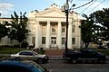
Lafourche Parish Courthouse
-
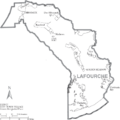
Map of Lafourche Parish with town names
See also
 In Spanish: Parroquia de Lafourche para niños
