Lockport, Louisiana facts for kids
Quick facts for kids
Town of Lockport
|
|
|---|---|
|
Town
|
|

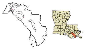
Location of Lockport in Lafourche Parish, Louisiana.
|
|

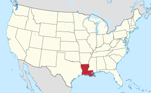
Location of Louisiana in the United States
|
|
| Country | |
| State | |
| Parish | Lafourche |
| Area | |
| • Total | 1.15 sq mi (2.98 km2) |
| • Land | 1.13 sq mi (2.93 km2) |
| • Water | 0.02 sq mi (0.05 km2) |
| Elevation | 10 ft (3 m) |
| Population
(2020)
|
|
| • Total | 2,490 |
| • Density | 2,197.71/sq mi (848.72/km2) |
| Time zone | UTC-6 (CST) |
| • Summer (DST) | UTC-5 (CDT) |
| ZIP Code |
70374
|
| Area code(s) | 985 |
| FIPS code | 22-44900 |
| Website | http://www.townoflockport.com |
Lockport is a small town located on Bayou Lafourche in Lafourche Parish, Louisiana, United States. In 2020, about 2,490 people lived there. It is part of the larger Houma–Bayou Cane–Thibodaux metropolitan area.
Contents
History of Lockport
Lockport was founded in 1835. Its story began with Jacques Lamotte, who owned a large piece of land along Bayou Lafourche in 1790. Later, some of this land was sold. In 1823, William Field bought some land and gave a part of it to the Barataria and Lafourche Canal Company. This company planned to build a canal to connect Bayou Terrebonne to New Orleans.
The Canal and Locks
In 1835, the area was mapped and called Longueville. This name later changed to Lockport. The canal was finished in 1847 and brought good times to the area. Three years later, special structures called "locks" were built where the canal met Bayou Lafourche. These locks helped boats move between different water levels.
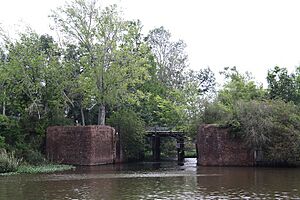
Boats used the canal a lot until 1868. After that, parts of the canal were not used anymore. In 1876, a flood called a "crevasse" partly damaged the locks. Today, you can still see parts of the old brick walls of the locks hidden by plants.
Growth and Development
Even though the canal didn't stay a big business success, Lockport continued to grow.
- In 1849, the first public school opened in a single room.
- In 1850, the Holy Savior Catholic Church was built.
- In 1879, a group of nuns started the Holy Savior School.
Lockport officially became a village in 1899. It then had a mayor and town leaders. Around 1900, the village had many businesses. These included a post office, brick sidewalks, and an iron bridge over the bayou. This bridge connected Lockport to Rita, a settlement on the other side of the bayou.
Challenges and Changes
In 1916, a big fire destroyed many businesses and homes in Lockport. After this fire, a water tower was built to help fight future fires. However, Hurricane Betsy destroyed this water tower in 1965.
By 1948, Lockport had grown so much that it changed from a village to a town. Its borders expanded, and the main highway (Highway 1) moved. New businesses opened along the new highway, making that area the town's main business center.
Today, Lockport is a modern community with different types of jobs. These include shipbuilding, sugarcane farming, oil and gas work, cattle raising, fishing, and vegetable farming. Lockport has kept its friendly, small-town feel, welcoming visitors along Bayou Lafourche.
Geography
Lockport is a small town with a total area of about 0.6 square miles (1.55 square kilometers). Most of this area is land, and a small part, about 0.04 square miles (0.1 square kilometers), is water.
Population Information
The table below shows how Lockport's population has changed over the years.
| Historical population | |||
|---|---|---|---|
| Census | Pop. | %± | |
| 1880 | 171 | — | |
| 1900 | 401 | — | |
| 1910 | 669 | 66.8% | |
| 1920 | 803 | 20.0% | |
| 1930 | 866 | 7.8% | |
| 1940 | 877 | 1.3% | |
| 1950 | 1,388 | 58.3% | |
| 1960 | 2,221 | 60.0% | |
| 1970 | 2,398 | 8.0% | |
| 1980 | 2,424 | 1.1% | |
| 1990 | 2,503 | 3.3% | |
| 2000 | 2,624 | 4.8% | |
| 2010 | 2,578 | −1.8% | |
| 2020 | 2,490 | −3.4% | |
| U.S. Decennial Census | |||
Population by Race in 2020
This table shows the different groups of people living in Lockport based on the 2020 United States Census.
| Race | Number | Percentage |
|---|---|---|
| White (non-Hispanic) | 2,104 | 84.5% |
| Black or African American (non-Hispanic) | 106 | 4.26% |
| Native American | 23 | 0.92% |
| Asian | 5 | 0.2% |
| Other/Mixed | 127 | 5.1% |
| Hispanic or Latino | 125 | 5.02% |
In 2020, there were 2,490 people living in Lockport, with 983 households and 598 families.
Education
The Lafourche Parish Public Schools district manages the public schools in Lockport.
- Lockport Lower Elementary School (for grades K-2)
- Lockport Upper Elementary School (for grades 3-5)
- Lockport Middle School
Students from Lockport attend Central Lafourche High School in Mathews. This high school was formed in 1966 when Lockport High School and Raceland High School joined together.
History of Schools
The first school in Lockport was a one-room schoolhouse that opened in 1849. Holy Savior Catholic School was started by nuns in 1879.
Community Support for Schools
The Camille and Braxton Hebert Memorial Fund Inc. is a non-profit organization that helped create playgrounds at both elementary schools. The playground at Lockport Lower is called "Braxton's Buddies." At Lockport Upper, a basketball court called "Camille's Court" was planned, with a plaque and flowerbed.
The Lafourche Parish Library has a branch located in Lockport.
For higher education, Fletcher Technical Community College serves Lafourche Parish and has a facility in Lockport. Delgado Community College also serves the area.
Notable People
- Jefferson J. DeBlanc: A pilot who received the Medal of Honor for his brave actions during World War II.
- Dick Guidry: A former state representative from Lafourche Parish and a past owner of drive-in movie theaters.
See also
 In Spanish: Lockport (Luisiana) para niños
 | Anna J. Cooper |
 | Mary McLeod Bethune |
 | Lillie Mae Bradford |


