St. John the Baptist Parish, Louisiana facts for kids
Quick facts for kids
St. John the Baptist Parish
|
|
|---|---|

|
|
| Motto(s):
"Heart of the River Parishes"
|
|

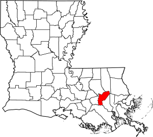
Location within the U.S. state of Louisiana
|
|
 Louisiana's location within the U.S. |
|
| Country | |
| State | |
| Founded | 1807 |
| Named for | St. John the Baptist Catholic Church in Edgard, built 1772 |
| Seat | Edgard |
| Largest community | LaPlace |
| Area | |
| • Total | 348 sq mi (900 km2) |
| • Land | 213 sq mi (550 km2) |
| • Water | 135 sq mi (350 km2) 39% |
| Population
(2020)
|
|
| • Total | 42,477 |
| • Density | 199.42/sq mi (77.00/km2) |
| Time zone | UTC−6 (Central) |
| • Summer (DST) | UTC−5 (CDT) |
| Congressional districts | 2nd, 6th |
St. John the Baptist Parish (often called SJBP) is a special kind of county in the U.S. state of Louisiana. It's known as a parish. In 2020, about 42,477 people lived here. The main town where the parish government is located is Edgard. The biggest community is LaPlace. Both Edgard and LaPlace are not officially incorporated as cities or towns.
St. John the Baptist Parish was created in 1807. It was one of the first 19 parishes in the Territory of Orleans. This territory later became the state of Louisiana.
The parish is part of the larger New Orleans–Metairie area. This means it's connected to the big city of New Orleans.
Long ago, in the 1700s and 1800s, this area was called the German Coast. This was because many German immigrants settled along the Mississippi River here in the 1720s. On January 8, 1811, a very important event happened here. It was the largest slave uprising in U.S. history. It's known as the German Coast Uprising. Over 200 enslaved people from different farms marched toward New Orleans. This uprising didn't last long.
This area is also part of the "Sugarland" or "sugar parishes." These areas grew a lot of sugar cane. Before the Civil War, many enslaved African Americans were forced to work on these large sugar farms. After slavery ended, many freedmen (formerly enslaved people) stayed in the area. They worked as farmers or on the plantations.
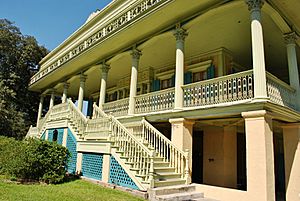
The parish has three famous old plantation houses. They are Evergreen Plantation, the Whitney Plantation Historic District, and San Francisco Plantation House. These buildings show what 19th-century architecture was like.
Contents
History of the Parish
St. John the Baptist Parish is home to one of the oldest settlements in Louisiana. It was settled after Natchitoches (1714) and New Orleans (1718). German Catholic families first settled here in the early 1720s. They built homes near the Mississippi River in places like Lucy, Garyville, and Reserve.
The area was controlled by France until 1763. Then, France lost the Seven Years' War (also called the French and Indian War in North America). So, France gave Louisiana to Spain.
During the Spanish rule, many Acadians arrived in south Louisiana. These were French people who had been forced out of what is now Nova Scotia by the British. The British had taken over French lands in Canada. The first Acadian village in Louisiana was in what is now Wallace. Both German and French cultures grew here. But French became the main language. These people developed a unique culture called Cajun.
In 1769, the Acadians wanted to build a church. The Spanish government agreed. Land was set aside on February 21, 1770. The first church was built where the modern St. John the Baptist Church stands today. It had the same name as the first German Coast chapel.
The first church leader was Father Bernardo de Limpach from Spain. The first church records show a marriage in 1772. This first church was washed away by a flood in 1821.
Early settlers received land from the French or Spanish kings. Land was often given in narrow strips along the river. This way, each farm could easily use the river to transport goods. The main house was built near the river. The rest of the land stretched back into the wetlands. This land was cleared to grow sugar cane.
For many years, most travel was by boat on the bayous, lakes, and the Mississippi River. St. John Parish had fertile land, about nine feet above sea level. This made it great for farming. In the late 1700s, farmers started growing more sugar cane. This crop needed many workers, so the demand for enslaved labor grew. Sugar production made many landowners wealthy. Before the Civil War, most people in the sugar and cotton parishes were Black.
With the money from sugar, some wealthy landowners built grand homes. Three of these homes still stand in St. John Parish today. They are important for their history and architecture. On the west side of the river are the Whitney Plantation Historic District and Evergreen Plantation. San Francisco Plantation House is on the east side.
You can visit San Francisco and Evergreen plantations for tours. Whitney Plantation is also being restored. Whitney and Evergreen plantations are part of the first 26 sites on the Louisiana African American Heritage Trail.
In January 1811, the 1811 German Coast Uprising began in this parish. It was the largest slave uprising in U.S. history, but it ended quickly. The enslaved people wanted freedom. They attacked five plantations and burned three houses. A main leader was Charles Deslondes, a mixed-race enslaved person. He was influenced by ideas from the French and Haitian Revolutions. Deslondes gathered over 200 enslaved people. They marched toward New Orleans. But they were defeated by armed groups. Many enslaved people were killed during the fights or after quick trials. Their actions showed how much African Americans wanted to be free.
Before the American Civil War, wealthy families often hired tutors to teach their children. These tutors lived with the families. There were no public schools back then.
After the Civil War, in 1869, families who wanted their children to learn French started private schools. English had become the official language. During the Reconstruction Era, the state government created the first public schools. It took time to get enough money for these schools. Black children's schools often received less money than white children's schools. The first high schools in Edgard and Reserve were built in 1909. Students traveled to school by horse-drawn buses or by train.
Geography of St. John the Baptist Parish
St. John the Baptist Parish covers about 348 square miles. About 213 square miles are land, and 135 square miles (39%) are water. It's one of the smaller parishes in Louisiana.
The parish is located on the Mississippi River. It's about 130 miles upriver from the Gulf of Mexico. It's also about 30 miles upriver from New Orleans. This area is called the River Region. It has many natural resources and a mild climate. The average temperature in New Orleans is about 55 degrees Fahrenheit in January and 84 degrees Fahrenheit in July. The area gets about 53 inches of rain each year.
Louisiana is known for producing natural gas, oil, sulfur, salt, and fur. St. John the Baptist Parish also produces sand, lime, clay, timber, seafood, and farm products.
The Mississippi River cuts through St. John the Baptist Parish. It divides the parish into two parts. The part north of the river is called the "east bank." The part south of the river is called the "west bank." This refers to how the river flows toward the Gulf of Mexico. The Mississippi River is very important for transportation. It helps support the large industries in the area.
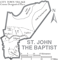
St. John the Baptist Parish is next to St. Charles Parish and Lake Pontchartrain to the east. It's bordered by Lake Pontchartrain and Lake Maurepas to the north. To the south are Lafourche Parish and Lac des Allemands. To the west is St. James Parish. St. John Parish is one of the four "River Parishes." It's considered the heart of this region.
This part of Louisiana, including St. James, Ascension, and St. Charles Parishes, is along the Mississippi River between New Orleans and Baton Rouge. Since the mid-1900s, when oil was found here, these parishes have had many chemical and oil processing factories. These industries provide many jobs.
Much of the parish is water or wetlands. Wetlands are protected by federal law. Building in wetlands is limited to what is allowed by the government.
Higher ground in the parish is found along the Mississippi River. The river's yearly floods left rich, fertile soil. This land has been used for farming crops like sugar cane, soybeans, and corn. Because of the good soil and river transportation, many farms and plantations were built here.
Many of these plantations were large areas of land. They had homes and other buildings on the higher ground. Some had very grand mansions. Three of these large homes still exist in St. John Parish.
The higher land along the river was used for crops. The wetlands were valued for their timber, hunting, and fishing. For many years, building in the River Parishes was only done on naturally higher ground that was less likely to flood. Even today, much of the parish is considered a flood risk area.
Neighboring Parishes
- Tangipahoa Parish (north)
- St. Charles Parish (southeast)
- Lafourche Parish (south)
- St. James Parish (west)
- Ascension Parish (northwest)
- Livingston Parish (northwest)
Communities in the Parish
St. John the Baptist Parish does not have any officially incorporated cities or towns.
Census-Designated Places
These are areas that the U.S. Census Bureau defines for statistical purposes.
Other Communities
These are smaller, unincorporated communities.
- Mount Airy
- Welcome
- Dutch Bayou
- Cornland
- Lions
Ghost Towns
St. John the Baptist Parish once had two more communities on its east bank: Ruddock and Frenier. They were located between Lake Maurepas and Lake Pontchartrain. Ruddock was a sawmill town founded in 1892. In September 1915, a hurricane hit both towns. It destroyed them and caused many deaths.
Today, Ruddock and Frenier are ghost towns. Only old wood and plants remain of Ruddock. Frenier still has a few buildings, like seafood restaurants and some houses built high to avoid floods. You can still see signs for Ruddock on I-55. Both towns are on Louisiana road maps.
People and Population
| Historical population | |||
|---|---|---|---|
| Census | Pop. | %± | |
| 1820 | 3,854 | — | |
| 1830 | 5,677 | 47.3% | |
| 1840 | 5,776 | 1.7% | |
| 1850 | 7,317 | 26.7% | |
| 1860 | 7,930 | 8.4% | |
| 1870 | 6,762 | −14.7% | |
| 1880 | 9,686 | 43.2% | |
| 1890 | 11,359 | 17.3% | |
| 1900 | 12,330 | 8.5% | |
| 1910 | 14,338 | 16.3% | |
| 1920 | 11,896 | −17.0% | |
| 1930 | 14,078 | 18.3% | |
| 1940 | 14,766 | 4.9% | |
| 1950 | 14,861 | 0.6% | |
| 1960 | 18,439 | 24.1% | |
| 1970 | 23,813 | 29.1% | |
| 1980 | 31,924 | 34.1% | |
| 1990 | 39,996 | 25.3% | |
| 2000 | 43,044 | 7.6% | |
| 2010 | 45,924 | 6.7% | |
| 2020 | 42,477 | −7.5% | |
| U.S. Decennial Census 1790-1960 1900-1990 1990-2000 2010-2013 |
|||
The population of St. John the Baptist Parish has changed over time. In 2020, there were 42,477 people living here.
| Race / Ethnicity (NH = Not Hispanic) | Pop 2000 | Pop 2010 | Pop 2020 | % 2000 | % 2010 | % 2020 |
|---|---|---|---|---|---|---|
| White alone (NH) | 21,946 | 18,374 | 13,348 | 50.99% | 40.01% | 31.42% |
| Black or African American alone (NH) | 19,204 | 24,405 | 24,076 | 44.61% | 53.14% | 56.68% |
| Native American alone (NH) | 100 | 116 | 105 | 0.23% | 0.25% | 0.25% |
| Asian alone (NH) | 222 | 312 | 314 | 0.52% | 0.68% | 0.74% |
| Pacific Islander alone (NH) | 10 | 21 | 7 | 0.02% | 0.05% | 0.02% |
| Other race alone (NH) | 31 | 51 | 140 | 0.07% | 0.11% | 0.33% |
| Mixed race or Multiracial (NH) | 301 | 470 | 1,196 | 0.70% | 1.02% | 2.82% |
| Hispanic or Latino (any race) | 1,230 | 2,175 | 3,291 | 2.86% | 4.74% | 7.75% |
| Total | 43,044 | 45,294 | 42,477 | 100.00% | 100.00% | 100.00% |
In 2019, about 42,242 people lived in the parish. Most people were Black or African American (56.5%). About 38.2% were non-Hispanic white. About 6.1% of the population was Hispanic or Latin American. Spanish was the second most-spoken language. About 4% of the people were born outside the U.S. French heritage was the largest ancestry group (9.7%).
In 2019, there were about 15,720 homes. Most people (78.5%) owned their homes. The average home value was $153,900. The average rent was $933. The average household income was $57,429. About 24.8% of the people lived in poverty.
By 2020, the population was 42,477. The number of Hispanic or Latino people and other non-White Americans has grown. This is part of a trend across the country.
Most people in the parish are Christian. In 2020, Roman Catholics were the largest Christian group. Many people also belonged to non-denominational Protestant churches.
Education in the Parish
The St. John the Baptist Parish School Board runs the public schools in the parish. There are ten public schools. The Archdiocese of New Orleans also manages five religious schools. There are also two private schools.
| Public Schools | City/Town | 2013-2014 Grade (SPS) | Change from 2012 to 2013 |
|---|---|---|---|
| Laplace Elementary/Middle School | LaPlace | B (89.0) | +2.90 |
| Garyville-Mt. Airy Math and Science Magnet School | Garyville/Mt. Airy | C (73.7) | -0.50 |
| Fifth Ward Elementary School | Reserve | C (71.5) | +3.50 |
| East St. John Elementary/Middle School | Reserve | C (79.4) | +3.20 |
| Emily C. Watkins Elementary/Middle School | LaPlace | C (80.6) | +14.30 |
| John L. Ory Communications Magnet School | LaPlace | A (106.7) | -2.50 |
| Lake Pontchartrain Elementary/Middle School | LaPlace | D (61.3) | -11.30 |
| West St. John Elementary/Middle School | Edgard | D (62.8) | +1.90 |
| East St. John High School | Reserve | C (75.8) | N/A |
| West St. John High School | Edgard | B (98.6) | +6.90 |
http://www.louisianabelieves.com/data/reportcards/2013/
| Religious Schools | City/Town |
|---|---|
| Ascension of Our Lord Catholic Elementary/Middle School | LaPlace |
| St. Joan of Arc Catholic Elementary/Middle School | LaPlace |
| St. Peter's Catholic Elementary/Middle School | Reserve |
| Our Lady of Grace Catholic Elementary/Middle School | Reserve |
| St. Charles Catholic High School | LaPlace |
| St. Timothy's Episcopal School | LaPlace |
| Private Schools | City/Town |
|---|---|
| Reserve Christian Elementary/Middle School | Reserve |
| Riverside Academy K-12 | Reserve |
The parish is also served by Delgado Community College.
Transportation in the Parish
Main Roads
 Interstate 10
 Interstate 55
 U.S. Highway 51
 U.S. Highway 61
 Louisiana Highway 18
 Louisiana Highway 44
 Louisiana Highway 3127
 Louisiana Highway 3188
 Louisiana Highway 3213
East Bank Roads - The main road on the east side of St. John Parish is Airline Highway (U.S. Highway 61). This road used to be the main way to get between Baton Rouge and New Orleans. Now, much of that traffic uses Interstate 10. Interstate 10 is a divided highway. It has two exits in St. John Parish, both in LaPlace.
Interstate 55 goes north and south toward Jackson, Mississippi. It crosses Interstate 10 in LaPlace.
River Road, also called Jefferson Highway or Louisiana Highway 44, runs next to the Mississippi River. Many large industries in the parish are located along this road.
West Bank Roads - Most of the development on the west side is along Louisiana Highway 18 (the Great River Road). This road also runs next to the Mississippi River. Another road on the west bank is Louisiana Highway 3127, or the River Parishes Highway. It also follows the Mississippi River. This road leads to Donaldsonville.
The Veterans Memorial Bridge (Louisiana Highway 3213) connects the east bank of St. James Parish to the west bank of St. John Parish. It opened in 2008. This bridge has helped new businesses grow on the west bank of St. John Parish.
You can also get to the west bank of St. John Parish by a ferry crossing at Reserve/Edgard. The Hale Boggs Memorial Bridge over the Mississippi in St. Charles Parish also provides access.
See also
In Spanish: Parroquia de St. John the Baptist para niños
 | Leon Lynch |
 | Milton P. Webster |
 | Ferdinand Smith |


