
Ascension Parish, Louisiana facts for kids
Quick facts for kids
Ascension Parish
|
||
|---|---|---|

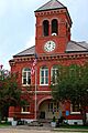
Ascension Parish Courthouse in Donaldsonville
|
||
|
||

Location within the U.S. state of Louisiana
|
||
 Louisiana's location within the U.S. |
||
| Country | ||
| State | ||
| Founded | 1807 | |
| Named for | Ascension of Jesus Christ | |
| Seat | Donaldsonville | |
| Largest city | Prairieville | |
| Area | ||
| • Total | 303 sq mi (780 km2) | |
| • Land | 290 sq mi (800 km2) | |
| • Water | 13 sq mi (30 km2) 3.75% | |
| Population
(2020)
|
||
| • Total | 126,500 | |
| • Density | 417.5/sq mi (161.2/km2) | |
| Time zone | UTC−6 (Central) | |
| • Summer (DST) | UTC−5 (CDT) | |
| Congressional districts | 2nd, 6th | |

Ascension Parish (French: Paroisse de l'Ascension; Spanish: Parroquia de la Ascensión) is a special type of county called a parish in the U.S. state of Louisiana. In 2020, about 126,500 people lived there. The main town, or parish seat, is Donaldsonville. This parish was created in 1807. Ascension Parish is also part of the larger Baton Rouge city area.
Ascension Parish is one of 22 parishes that make up Acadiana. This area is known as the home of the Cajun people and their unique culture. You'll often hear French or Cajun French spoken here. The people celebrate many fun festivals. These include the Boucherie Festival, the Lagniappe Music and Seafood Festival, and the Crawfish Festival. The biggest city in Ascension Parish is Gonzales. It's even called the "Jambalaya Capital of the World" because of its famous Jambalaya Festival!
Contents
History of Ascension Parish
The first European settlers in the Ascension and Gonzales areas were mostly from France and Spain. They settled alongside the Houma Indians who already lived there.
Between 1769 and 1777, Governor Luis de Unzaga helped create new settlements. He encouraged French Acadians and people from Malaga, Spain, to move to the rich Mississippi River region. Ascension Parish grew from these early European settlements.
In 2016, Louisiana experienced major floods. About one-third of all homes in Ascension Parish were flooded. Around 15,000 homes and businesses were affected. Most of the damage happened in the Galvez-St. Amant area.
Exploring Ascension Parish Geography
According to the U.S. Census Bureau, Ascension Parish covers about 303 square miles. Most of this area, 290 square miles, is land. The remaining 13 square miles (about 4.2%) is water. It is the fourth-smallest parish in Louisiana by total area.
Important Waterways
Ascension Parish has many rivers, bayous, and canals. These waterways are very important to the area's environment and history. Some of the main ones include:
- Alligator Bayou
- Amite River
- Bayou Antoine
- Bayou Manchac
- Bayou Francois
- Bayou Lafourche
- Blind River
- Mississippi River
- New River
- Spanish Lake
Major Roads and Highways
Several important highways pass through Ascension Parish. These roads connect the parish to other parts of Louisiana and beyond.
 Interstate 10
 U.S. Highway 61
 Louisiana Highway 1
 Louisiana Highway 16
 Louisiana Highway 18
 Louisiana Highway 22
 Louisiana Highway 30
 Louisiana Highway 42
 Louisiana Highway 44
 Louisiana Highway 70
 Louisiana Highway 73
 Louisiana Highway 308
 Louisiana Highway 3127
Neighboring Parishes
Ascension Parish shares borders with several other parishes:
- East Baton Rouge Parish (north)
- Livingston Parish (northeast)
- St. John the Baptist Parish (east)
- St. James Parish (southeast)
- Assumption Parish (southwest)
- Iberville Parish (west)
Towns and Communities
Ascension Parish has several cities, towns, and smaller communities.
Cities
- Donaldsonville (This is the parish seat, where the main government offices are.)
- Gonzales
Town
Census-Designated Places
These are areas that are like towns but are not officially incorporated as cities or towns.
Other Communities
Many smaller, unincorporated communities are also part of Ascension Parish.
- Aben
- Acy
- Belle Helene
- Brittany
- Burnside
- Dutchtown
- Galvez
- Geismar
- Hope Villa
- Saint Amant
- Smoke Bend
Population and People
| Historical population | |||
|---|---|---|---|
| Census | Pop. | %± | |
| 1810 | 2,219 | — | |
| 1820 | 3,728 | 68.0% | |
| 1830 | 5,246 | 40.7% | |
| 1840 | 6,951 | 32.5% | |
| 1850 | 10,752 | 54.7% | |
| 1860 | 11,484 | 6.8% | |
| 1870 | 11,577 | 0.8% | |
| 1880 | 16,895 | 45.9% | |
| 1890 | 19,545 | 15.7% | |
| 1900 | 24,142 | 23.5% | |
| 1910 | 23,887 | −1.1% | |
| 1920 | 22,155 | −7.3% | |
| 1930 | 18,438 | −16.8% | |
| 1940 | 21,215 | 15.1% | |
| 1950 | 22,387 | 5.5% | |
| 1960 | 27,927 | 24.7% | |
| 1970 | 37,086 | 32.8% | |
| 1980 | 50,068 | 35.0% | |
| 1990 | 58,214 | 16.3% | |
| 2000 | 76,627 | 31.6% | |
| 2010 | 107,215 | 39.9% | |
| 2020 | 126,500 | 18.0% | |
| U.S. Decennial Census 1790-1960 1900-1990 1990-2000 2010-2019 |
|||
The population of Ascension Parish has grown a lot over the years. In 1810, there were just over 2,200 people. By 1990, the population had reached over 58,000. The 2010 census showed 107,215 people. In 2020, the population grew to 126,500 people.
Historically, many people in Ascension Parish were of French and Spanish descent. In 2020, about 63% of the population was non-Hispanic white. About 24% were Black or African American. Around 8% were Hispanic or Latino, and 1.3% were Asian.
Many people in Ascension Parish are Christians. The Roman Catholic Church is the largest Christian group. There are also many non-denominational Christian churches and Baptist churches.
Education in Ascension Parish
The Ascension Parish School Board runs the public schools in the area. There are also private schools for students. Since 1998, the parish has been home to River Parishes Community College. This college offers higher education opportunities.
Local Media
Ascension Parish has two local newspapers. The Gonzales Weekly Citizen is published twice a week. It was formed when two older newspapers merged. Donaldsonville Chief started in 1871. It is the oldest continuously published newspaper in the parish.
National Guard Presence
The 922nd Engineer Company (Horizontal) is located in Ascension Parish. This unit is part of the 769th Engineer Battalion. The 1021st Vertical Engineer Company is also in Gonzales, Louisiana. These units are part of the National Guard.
Images for kids
-

The official flag of Ascension Parish.
-
The Ascension Parish Courthouse in Donaldsonville.
See also
 In Spanish: Parroquia de Ascension para niños
