Livingston Parish, Louisiana facts for kids
Quick facts for kids
Livingston Parish
|
|
|---|---|

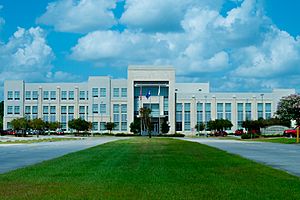
Livingston Parish Courthouse in Livingston
|
|

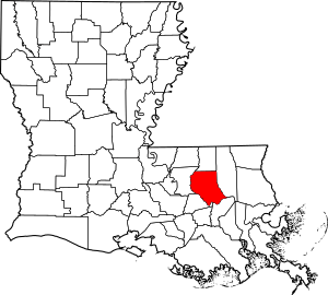
Location within the U.S. state of Louisiana
|
|
 Louisiana's location within the U.S. |
|
| Country | |
| State | |
| Founded | February 10, 1832 |
| Named for | Edward Livingston |
| Seat | Livingston |
| Largest city | Denham Springs |
| Area | |
| • Total | 703 sq mi (1,820 km2) |
| • Land | 648 sq mi (1,680 km2) |
| • Water | 55 sq mi (140 km2) 7.8% |
| Population
(2020)
|
|
| • Total | 142,282 |
| • Density | 202.39/sq mi (78.14/km2) |
| Time zone | UTC−6 (Central) |
| • Summer (DST) | UTC−5 (CDT) |
| Congressional district | 6th |
Livingston Parish is a special kind of county in the U.S. state of Louisiana. Its main town, or parish seat, is Livingston. Livingston Parish is part of a region called the Florida Parishes. This area was once controlled by the Spanish Empire, not the French Empire, which is different from most of Louisiana.
The parish is named after Edward Livingston. He was an American jurist (a legal expert) and statesman. He helped write the laws for Louisiana in 1825.
Livingston Parish is part of the larger Baton Rouge metropolitan area. In 2020, about 142,282 people lived there. It is also part of Louisiana's 6th congressional district.
Contents
History of Livingston Parish
Livingston Parish was officially created in 1832. The Louisiana State Legislature formed it from a part of St. Helena Parish.
Over the years, the main town (parish seat) changed several times. It was first Van Buren from 1832 to 1835. Then it moved to Springfield (1835–1872). After that, it was Port Vincent (1872–1881), and then Centerville (1881–1941). Finally, Livingston became the permanent parish seat in 1941.
In 2016, Livingston Parish faced severe flooding. Many homes in the area were badly damaged. It was a very difficult time for the people living there.
Geography of Livingston Parish
Livingston Parish covers a total area of about 703 square miles. Most of this area, about 648 square miles, is land. The remaining 55 square miles, which is about 7.8%, is covered by water.
Main Roads in Livingston Parish
Many important roads run through Livingston Parish. These highways help people travel around the parish and to other parts of Louisiana.
 Interstate 12
 U.S. Highway 190
 Louisiana Highway 16
 Louisiana Highway 22
 Louisiana Highway 40
 Louisiana Highway 42
 Louisiana Highway 43
 Louisiana Highway 63
 Louisiana Highway 444
 Louisiana Highway 447
State Park in Livingston Parish
- Tickfaw State Park is a great place to visit. It offers outdoor activities and a chance to explore nature.
Neighboring Parishes
Livingston Parish shares borders with several other parishes:
- St. Helena Parish (to the north)
- Tangipahoa Parish (to the east)
- St. John the Baptist Parish (to the southeast)
- Ascension Parish (to the southwest)
- East Baton Rouge Parish (to the west)
Communities in Livingston Parish
Livingston Parish has several towns and cities where people live and work.
Cities in Livingston Parish
Towns in Livingston Parish
- Livingston (This is the parish seat)
- Springfield
- Albany
Villages in Livingston Parish
Census-Designated Place
- Watson is a community that is counted for census purposes.
Unincorporated Communities
These are smaller communities that are not officially cities or towns.
Historic Community
- Van Buren was once an important community in the parish's history.
Population and People
The number of people living in Livingston Parish has grown a lot over the years.
| Historical population | |||
|---|---|---|---|
| Census | Pop. | %± | |
| 1840 | 2,315 | — | |
| 1850 | 3,385 | 46.2% | |
| 1860 | 4,431 | 30.9% | |
| 1870 | 4,026 | −9.1% | |
| 1880 | 5,258 | 30.6% | |
| 1890 | 5,769 | 9.7% | |
| 1900 | 8,100 | 40.4% | |
| 1910 | 10,627 | 31.2% | |
| 1920 | 11,643 | 9.6% | |
| 1930 | 18,206 | 56.4% | |
| 1940 | 17,790 | −2.3% | |
| 1950 | 20,054 | 12.7% | |
| 1960 | 26,974 | 34.5% | |
| 1970 | 36,511 | 35.4% | |
| 1980 | 58,806 | 61.1% | |
| 1990 | 70,526 | 19.9% | |
| 2000 | 91,814 | 30.2% | |
| 2010 | 128,026 | 39.4% | |
| 2020 | 142,282 | 11.1% | |
| U.S. Decennial Census | |||
| Group | Number | Percentage |
|---|---|---|
| White (not Hispanic) | 114,876 | 80.74% |
| Black or African American (not Hispanic) | 11,178 | 7.86% |
| Native American | 365 | 0.26% |
| Asian | 1,116 | 0.78% |
| Pacific Islander | 36 | 0.03% |
| Other/Mixed | 5,920 | 4.16% |
| Hispanic or Latino | 8,791 | 6.18% |
In 2020, the total population of Livingston Parish was 142,282 people. Most of the people living in the parish are White. There are also significant numbers of Black or African American people and Hispanic or Latino people.
After Hurricane Katrina in 2005, many families from other areas moved to Livingston Parish. This caused the population to grow even more. By 2006, the population had increased to over 111,000 people.
In 2019, about 81.8% of people in the parish owned their homes. The average value of a house was around $167,100.
Many different religious groups are found in Livingston Parish. The largest religious group is the Southern Baptist Convention. The Catholic Church is the second largest group, followed by non-denominational Protestants.
Economy and Jobs
Livingston Parish is home to an important scientific facility. It has one of the two gravitational wave observatories in the world. This observatory helps scientists study gravitational waves from space.
As of 2015, Livingston Parish was the fastest-growing parish in Louisiana. This means more people are moving there and more businesses are opening.
Education in Livingston Parish
All public schools in Livingston Parish are managed by the Livingston Parish Public Schools system. Students in the parish can also attend Baton Rouge Community College for higher education.
See also
 In Spanish: Parroquia de Livingston para niños
 | Delilah Pierce |
 | Gordon Parks |
 | Augusta Savage |
 | Charles Ethan Porter |

