Tangipahoa Parish, Louisiana facts for kids
Quick facts for kids
Tangipahoa Parish
|
|
|---|---|

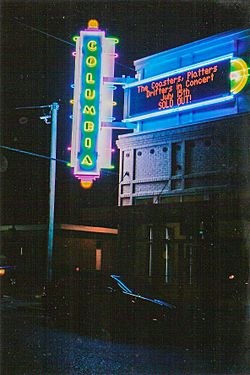
Columbia Theatre for the Performing Arts in Hammond
|
|

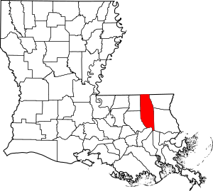
Location within the U.S. state of Louisiana
|
|
 Louisiana's location within the U.S. |
|
| Country | |
| State | |
| Founded | March 6, 1869 |
| Named for | Acolapissa word meaning ear of corn or those who gather corn |
| Seat | Amite City |
| Largest city | Hammond |
| Area | |
| • Total | 823 sq mi (2,130 km2) |
| • Land | 791 sq mi (2,050 km2) |
| • Water | 32 sq mi (80 km2) 3.9% |
| Population
(2020)
|
|
| • Total | 133,157 |
| • Density | 161.79/sq mi (62.47/km2) |
| Time zone | UTC−6 (Central) |
| • Summer (DST) | UTC−5 (CDT) |
| Congressional districts | 1st, 5th |

Tangipahoa Parish is a special kind of county in the state of Louisiana. It's located in the southeastern part of the state. In 2020, about 133,157 people lived here. The main town where the local government is located is Amite City. However, the biggest city in the parish is Hammond. You can also find Southeastern Louisiana University in Hammond. A large lake called Lake Pontchartrain is on the southeastern side of the parish.
The name Tangipahoa comes from an old Acolapissa Native American word. It means "ear of corn" or "those who gather corn." This area became a parish in 1869, after the American Civil War.
Tangipahoa Parish is part of a larger area that includes Hammond and Baton Rouge. It's also one of the "Florida Parishes," which were once part of a different territory called West Florida.
Contents
Exploring Tangipahoa Parish History
Tangipahoa Parish was created in 1869. It was formed from parts of four other parishes: Livingston, St. Helena, St. Tammany, and Washington. The area was affected by a big flood in 1932.
The name of the parish comes from the Tangipahoa River. It's also named after the historic Tangipahoa Native American people who lived there long ago.
Geography and Nature of Tangipahoa Parish
According to the U.S. Census Bureau, Tangipahoa Parish covers about 823 square miles. Most of this area, about 791 square miles, is land. The remaining 32 square miles (about 3.9%) is water. As mentioned, Lake Pontchartrain is on the southeast side of the parish.
The southern part of the parish, especially near Ponchatoula, has many coastal swamps and marshes. These areas have dark, rich soil and thick layers of peat, which is partly decayed plant matter. This type of land is common in freshwater marsh and swamp areas.
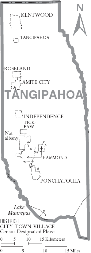
Cities and Towns in Tangipahoa Parish
Tangipahoa Parish has several communities, from large cities to small villages.
Major Cities
Towns to Visit
- Amite City (This is the parish seat, where the main government offices are.)
- Independence
- Kentwood
- Roseland
Small Villages
Other Communities
There are also other smaller areas that are not officially cities or towns:
- Natalbany (a census-designated place)
- Baptist
- Fluker
- Husser
- Loranger
- Manchac (also known as Akers)
- Robert
- Rosaryville
- Wilmer
Population Changes in Tangipahoa Parish
The population of Tangipahoa Parish has grown a lot over the years. Here's how it has changed:
| Historical population | |||
|---|---|---|---|
| Census | Pop. | %± | |
| 1870 | 7,928 | — | |
| 1880 | 9,638 | 21.6% | |
| 1890 | 12,655 | 31.3% | |
| 1900 | 17,625 | 39.3% | |
| 1910 | 29,160 | 65.4% | |
| 1920 | 31,440 | 7.8% | |
| 1930 | 46,227 | 47.0% | |
| 1940 | 45,519 | −1.5% | |
| 1950 | 53,218 | 16.9% | |
| 1960 | 59,434 | 11.7% | |
| 1970 | 65,875 | 10.8% | |
| 1980 | 80,698 | 22.5% | |
| 1990 | 85,709 | 6.2% | |
| 2000 | 100,588 | 17.4% | |
| 2010 | 121,097 | 20.4% | |
| 2020 | 133,157 | 10.0% | |
| U.S. Decennial Census 1790-1960 1900-1990 1990-2000 2010 |
|||
In 2020, there were 133,157 people living in the parish. These people lived in about 46,526 households, which included 31,420 families.
Here's a look at the different groups of people living in Tangipahoa Parish in 2020:
| Race | Number | Percentage |
|---|---|---|
| White (not Hispanic) | 79,825 | 59.95% |
| Black or African American (not Hispanic) | 39,770 | 29.87% |
| Native American | 409 | 0.31% |
| Asian | 942 | 0.71% |
| Pacific Islander | 23 | 0.02% |
| Other/Mixed | 4,946 | 3.71% |
| Hispanic or Latino | 7,242 | 5.44% |
Education in Tangipahoa Parish
The schools in Tangipahoa Parish are managed by the Tangipahoa Parish School System. As mentioned before, Southeastern Louisiana University is a large college located in Hammond.
The school board, which is elected by the people, is in charge of the Tangipahoa Parish School System. In the past, there were court orders for the school board to make sure that a certain number of teachers hired were Black. This was to correct old issues. For many years, the school board did not fully meet these goals. In 2010, a new court decision reinforced the earlier orders.
National Guard Presence
Tangipahoa Parish is home to several units of the Louisiana National Guard. These include the 204th Theater Airfield Operations Group and a support company from the 205th Engineer Battalion. These units are based in Hammond. Another part of the 205th Engineer Battalion is in Independence, Louisiana. The 236th Combat Communications Squadron of the Louisiana Air National Guard is also located at the Hammond Airport.
Getting Around Tangipahoa Parish
Train Travel
The City of New Orleans is a daily train run by Amtrak. It stops in Hammond. This train travels north to Chicago and south to New Orleans. About 15,000 people use this train each year in Hammond. The route between Hammond and Chicago is one of the busiest on this train line.
The main train tracks that carry freight through the parish used to belong to the Illinois Central company. Now, they are part of the CN system and are still very active.
Major Highways
Many important roads run through Tangipahoa Parish, making it easy to travel.
 Interstate 12
 Interstate 55
 U.S. Route 51
 U.S. Route 190
 Louisiana Highway 10
 Louisiana Highway 16
 Louisiana Highway 22
 Louisiana Highway 38
 Louisiana Highway 40
 Louisiana Highway 440
 Louisiana Highway 442
 Louisiana Highway 443
 Louisiana Highway 445
 Louisiana Highway 1040
 Louisiana Highway 1045
 Louisiana Highway 1046
 Louisiana Highway 1048
 Louisiana Highway 1049
 Louisiana Highway 1050
 Louisiana Highway 1051
 Louisiana Highway 1053
 Louisiana Highway 1054
 Louisiana Highway 1055
 Louisiana Highway 1056
 Louisiana Highway 1057
 Louisiana Highway 1061
 Louisiana Highway 1062
 Louisiana Highway 1063
 Louisiana Highway 1064
 Louisiana Highway 1065
 Louisiana Highway 1249
 Louisiana Highway 3158
 Louisiana Highway 3234
Famous People from Tangipahoa Parish
Many notable people have connections to Tangipahoa Parish:
- Robert Alford – Professional football player
- Chris Broadwater – Former state representative
- Nick Bruno – President of the University of Louisiana at Monroe
- Hodding Carter – Famous journalist
- John L. Crain – President of Southeastern Louisiana University
- Donald Dykes – Former professional football player
- John Bel Edwards – Former Governor of Louisiana
- C. B. Forgotston – Political activist
- Barbara Forrest – Critic of intelligent design
- Tim Gautreaux – Writer
- Kevin Hughes – Former professional football player
- Bolivar E. Kemp – U.S. representative
- Bolivar Edwards Kemp, Jr. – Former Louisiana Attorney General
- Wade Miley – Professional baseball pitcher
- Harlan Miller – Professional football player
- James H. Morrison – Former U.S. representative
- Kim Mulkey – College basketball coach and former player
- Rufus Porter – Former professional football player
- Billy Reid – Fashion designer
- Weldon Russell – Former state representative
- Britney Spears – Famous entertainer
- DeVonta Smith – Professional football player, Heisman Trophy winner
- Jackie Smith – Former professional football player, NFL Hall of Famer
- Irma Thomas – Grammy Award-winning singer
- LaBrandon Toefield – Former professional football player
- Earl Wilson – Former major league baseball player
- Harry D. Wilson – Louisiana state representative and agriculture commissioner
- Justin Wilson – Chef and humorist
See also
 In Spanish: Parroquia de Tangipahoa para niños
 | Precious Adams |
 | Lauren Anderson |
 | Janet Collins |


