
Hammond, Louisiana facts for kids
Quick facts for kids
Hammond, Louisiana
|
|
|---|---|

The Hammond Oak, located in the 500 block of East Charles Street: The grave of founder Peter av Hammerdal (Peter Hammond) is under this tree, along with the graves of several family members and enslaved people.
|
|

Location of Hammond in Tangipahoa Parish, Louisiana
|
|

Hammond, Louisiana
Location in Louisiana

Hammond, Louisiana
Location in the United States
|
|
| Country | |
| State | |
| Parish | Tangipahoa |
| Settled | 1818 |
| Chartered | 1889 |
| Area | |
| • Total | 14.25 sq mi (36.92 km2) |
| • Land | 14.25 sq mi (36.91 km2) |
| • Water | 0.00 sq mi (0.01 km2) |
| Elevation | 39 ft (12 m) |
| Population
(2020)
|
|
| • Total | 19,584 |
| • Density | 1,374.22/sq mi (530.59/km2) |
| Time zone | UTC−6 (CST) |
| • Summer (DST) | UTC−5 (CDT) |
| ZIP code |
70401, 70403
|
| Area code(s) | 985 |
| FIPS code | 22-32755 |
| GNIS feature ID | 2403788 |
| Website | www.hammond.org |
Hammond is the biggest city in Tangipahoa Parish, Louisiana, United States. It is about 45 miles (72 km) east of Baton Rouge and 45 miles (72 km) northwest of New Orleans. In 2020, its population was 19,584 people.
Hammond is home to Southeastern Louisiana University. It is the main city of the Hammond metropolitan area. This area includes all of Tangipahoa Parish.
Contents
History of Hammond

How Hammond Began (1800s)
The city gets its name from Peter Hammond (1798–1870). He was a Swedish immigrant, and his original name was Peter av Hammerdal. He was the first European settler in the area, arriving around 1818. Peter was a sailor who had been held prisoner by the British during the Napoleonic Wars. He escaped and eventually reached New Orleans.
Peter Hammond used his money to buy land near Lake Pontchartrain. He started a plantation to grow trees. He used the wood to make things like masts for ships and charcoal. He would transport these goods by oxcart to the Natalbany River at Springfield.
In 1854, a railroad called the New Orleans, Jackson and Great Northern Railroad came through the area. This railroad helped the town grow into a center for trade and transport. The spot where the railroad met the trail to Springfield was first called Hammond's Crossing.
During the American Civil War, Hammond was a place where shoes were made for the Confederate States Army. Charles Emery Cate helped build this shoe industry. He bought land in the city in 1860 for his home, a shoe factory, and a sawmill. After the war, Cate planned the city's streets, using the railroad line as a guide. Cate Street is named after him.
After the Civil War, more businesses came to Hammond. By the late 1800s, it was a popular stop for train passengers. People from the north traveled south through Hammond. People from New Orleans came north to escape summer yellow fever outbreaks. The city later became famous for shipping strawberries. A historical marker in downtown Hammond calls it the "Strawberry Capital of America."
Hammond in the 1900s and 2000s
In the 1930s, a newspaper called the Hammond Daily Courier was started by Hodding Carter. He later won a Pulitzer Prize for his writing about the Civil Rights Movement.
The Tangipahoa Parish Library – Hammond branch opened in 1944. Since 1959, The Daily Star has been Hammond's local daily newspaper.
During World War II, the Hammond Airport was used as a camp for prisoners of war from Nazi Germany. The U.S. Army also used a large area east of the city as a bombing and gunnery range.
Today, Hammond is crossed by two major highways: Interstate 12 and Interstate 55. Its airport has a very long runway. This runway can be used as a backup landing spot for the Louis Armstrong New Orleans International Airport. It is also a training site for the Louisiana Army National Guard.
About 15 miles (24 km) south of Hammond is Port Manchac. This port connects to Lake Pontchartrain and then to the Gulf of Mexico. Because of its location with highways, railroads, an airport, and a port, Hammond has become a major transportation hub. Many warehouses are located here, and it's a distribution point for big businesses like Walmart. Southeastern Louisiana University in Hammond even offers a special degree in supply chain management.
In 2021, Hammond was hit by Hurricane Ida. The hurricane brought a lot of rain and strong winds. This caused severe flooding and damage to the city.
Geography and Climate
Hammond covers about 12.8 square miles (33.2 km2) of land. Only a tiny part is water.
Hammond's Climate
The weather in Hammond has hot, humid summers. Winters are usually mild to cool. It has a humid subtropical climate. This means it gets plenty of rain all year, and temperatures are warm for most of the year.
Population and People
| Historical population | |||
|---|---|---|---|
| Census | Pop. | %± | |
| 1880 | 277 | — | |
| 1890 | 692 | 149.8% | |
| 1900 | 1,511 | 118.4% | |
| 1910 | 2,942 | 94.7% | |
| 1920 | 3,855 | 31.0% | |
| 1930 | 6,072 | 57.5% | |
| 1940 | 6,033 | −0.6% | |
| 1950 | 8,010 | 32.8% | |
| 1960 | 10,563 | 31.9% | |
| 1970 | 12,487 | 18.2% | |
| 1980 | 15,226 | 21.9% | |
| 1990 | 15,871 | 4.2% | |
| 2000 | 17,639 | 11.1% | |
| 2010 | 20,019 | 13.5% | |
| 2020 | 19,584 | −2.2% | |
| U.S. Decennial Census | |||
| Race | Number | Percentage |
|---|---|---|
| White (non-Hispanic) | 8,584 | 43.83% |
| Black or African American (non-Hispanic) | 8,865 | 45.27% |
| Native American | 62 | 0.32% |
| Asian | 327 | 1.67% |
| Pacific Islander | 6 | 0.03% |
| Other/Mixed | 693 | 3.54% |
| Hispanic or Latino | 1,047 | 5.35% |
In 2020, there were 19,584 people living in Hammond. There were 6,871 households and 3,972 families.
Education in Hammond
Southeastern Louisiana University (SLU) is in Hammond. It is one of the state's regional universities. It is also one of the city's biggest employers. SLU was started in 1925. Hammond is also home to Northshore Technical Community College. There are two other colleges, Petra College and Compass Career College. They offer training for health and medical jobs.
The public schools in Hammond are part of the Tangipahoa Parish School System. These schools include:
- Hammond High Magnet School
- Hammond Junior High
- Eastside Elementary
- Westside Elementary
- SLU Laboratory School
- Crystal Academy (an alternative school)
The Catholic Church runs two schools in Hammond:
- Holy Ghost Catholic School (for pre-kindergarten through 8th grades)
- Saint Thomas Aquinas High School (just north of the city)
There are also private schools like Trafton Academy (pre-K through 8th) and Oaks Montessori School (pre-K through 8th).
In 2018, reports showed that about 74% of people in Hammond had a high school diploma. About 20% had a college degree.
Sports, Parks, and Fun
The Southeastern Louisiana Lions sports teams play at different places in Hammond.
Chappapeela Sports Park is a big place for sports. You can play American football, baseball, basketball, lacrosse, soccer, softball, and volleyball there.
Hammond has several public parks, including:
- Cate Square Park
- Zemurray Park (which has a public swimming pool)
- North Oaks Park
- Mooney Avenue Park
- Clarke Park
- Martin Luther King Park
- Jackson Park
- Hammond Dreamland Park
Besides youth sports, there are adult leagues for flag football, basketball, kickball, and volleyball. Other activities like line dancing, Zumba, and crafting are also available for adults.
Media and News
Hammond gets most of its TV and radio from Baton Rouge and New Orleans. But it also has its own local news and entertainment:
- Action News 17 (online streaming)
- Daily Star newspaper
- KSLU FM 90.9 (from Southeastern Louisiana University)
- WZEN-LP FM 107.9
- WFPR AM 1400
- WHMD FM 107.1 radio (also called "Kajun Radio")
- WTGG FM 96.5
Getting Around Hammond
Hammond has good ways to travel by train, car, and plane.
Train Travel
The City of New Orleans train stops in Hammond every day. This train goes between New Orleans and Chicago. About 15,000 passengers use the Hammond station each year. Many people travel to or from Baton Rouge, which is about 40 miles (64 km) away.
The train station was built in 1912 and looks like a Queen Anne-style building. It was updated in 2008.
Highways for Cars
Hammond is successful partly because it's where two busy interstate highways meet:
 Interstate 12: This highway goes from Baton Rouge to Slidell. It's a shortcut for drivers on Interstate 10 to avoid traffic in New Orleans.
 Interstate 55: This highway goes all the way from Laplace (near New Orleans) to Chicago. It also passes through big cities like Jackson, Mississippi, Memphis, and St. Louis.
Hammond is about 40 miles (64 km) from Baton Rouge and 46 miles (74 km) from New Orleans.
Two U.S. highways also serve the city:
 U.S. Route 51 (Morrison Boulevard)
 U.S. Route 190 (Thomas Street / Morris Avenue)
Several state highways also go through the area.
Hammond Airport
The Hammond Northshore Regional Airport has a very long runway. It's long enough for large planes like the Concorde (which flew from 1976–2003). It can also be used as a backup airport for the Louis Armstrong New Orleans International Airport. The biggest unit of the Louisiana Army National Guard is based here. The airport is also home to the 236th Combat Communications Squadron of the Louisiana Air National Guard.
The airport does not have regular passenger flights. However, it is used for private and corporate planes.
Famous People from Hammond
Many notable people have connections to Hammond:
- Robert Alford, a football player for the Arizona Cardinals
- Alyssa Carson, who hopes to become an astronaut
- Wade Miley, a baseball pitcher for the Milwaukee Brewers
- James H. Morrison, a U.S. Representative for Louisiana
- Kim Mulkey, a famous basketball coach for LSU Tigers women's basketball
- Jimmy Noone, a musician and bandleader
- Robin Roberts, host of Good Morning America
- Jamie Lynn Spears, an actress and country music singer
- Tyjae Spears, a football player for the Tennessee Titans
Hammond in Movies and Songs
- The first season of the NBC television series In the Heat of the Night was filmed in Hammond in 1988.
- The song "Hammond Song" by Maggie Roche is about moving to Hammond.
Images for kids
-
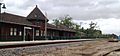
Known locally as the Depot, the Amtrak station dates from 1912. Refurbished with a raised passenger platform, the station offers direct service to New Orleans and Chicago on routes owned by the Canadian National Railway.
-
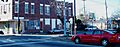
Intersection of LA 1065 (North Cherry Street) and US 190 (East Thomas Street) in Hammond's Historic District: The building in the background is Dantone's Grocery, founded in 1912 by Italian immigrants.
-
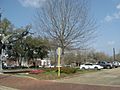
Part of the original (1854) route of the New Orleans, Jackson and Great Northern railway, still operational in the Canadian National Railway line at this railroad crossing in Hammond
-
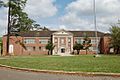
Lucius McGehee Hall on the campus of Southeastern Louisiana University in Hammond is a sturdy example of Depression Gothic architecture. It is on the National Register of Historic Places.


See also
 In Spanish: Hammond (Luisiana) para niños
