Terrebonne Parish, Louisiana facts for kids
Quick facts for kids
Terrebonne Parish
|
||
|---|---|---|
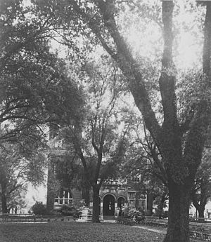
Terrebonne Parish Courthouse
|
||
|
||
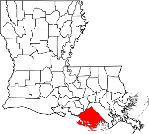
Location within the U.S. state of Louisiana
|
||
 Louisiana's location within the U.S. |
||
| Country | ||
| State | ||
| Founded | March 22, 1822 | |
| Named for | terre bonne, French for good earth | |
| Seat | Houma | |
| Largest city | Houma | |
| Area | ||
| • Total | 2,080 sq mi (5,400 km2) | |
| • Land | 1,232 sq mi (3,190 km2) | |
| • Water | 850 sq mi (2,200 km2) 41% | |
| Population
(2020)
|
||
| • Total | 109,580 | |
| • Density | 52.68/sq mi (20.34/km2) | |
| Time zone | UTC−6 (Central) | |
| • Summer (DST) | UTC−5 (CDT) | |
| Congressional districts | 1st, 6th | |
Terrebonne Parish (pronounced TERR-ə-BOHN) is a special kind of county called a parish in the southern part of Louisiana. It's known for its beautiful bayous and rich history.
In 2020, about 109,580 people lived here. The main town and government center is Houma. The parish was created in 1822. Terrebonne Parish is also part of the larger Houma-Thibodaux area.
It is the fifth-largest parish in Louisiana by land size. Since the 1700s, it has been a big center for Cajun culture. Many people here still speak French at home.
Contents
A Look Back in Time
The main town, Houma, got its name from the Houma people. This Native American tribe lived in the area. The word houma means "red," and their symbol was the crawfish.
Historians believe the Houma tribe came from areas that are now Mississippi and Alabama. They moved south to escape conflicts with other tribes and European settlers. By the mid-1700s, they settled in what is now Terrebonne Parish.
They set up a camp called Ouiski Bayou. This was on higher ground near where downtown Houma is today. Later, European settlements pushed them further south towards the coast. You can still find signs of the Houma Tribe in this area.
Terrebonne Parish was officially created on March 22, 1822. It was formed from the southern part of Lafourche Interior. It stretches all the way to the Gulf of Mexico. Early French settlers named it terre bonne, which means "good earth," because of its fertile soil.
In 1834, the city of Houma was founded. This was done to create a central and easy-to-reach parish seat. Before this, the government center was in Williamsburg (now Bayou Cane). Houma was chosen because it was where six bayous met. This made it a great place for trade and travel by water.
Early European Settlers
Most European settlers came to Terrebonne from the Mississippi River. They traveled down Bayou Lafourche to Bayou Terrebonne. In 1762, many French colonists moved to the bayou country from New Orleans. This happened after Spain took control of the colony.
Spanish leaders offered land to newcomers in the bayou areas. Many French people came, but British and Spanish settlers also claimed land.
Other settlers arrived in 1760. These were French colonists from Acadia (now Nova Scotia). The British had forced them out in 1755. These people became known as "Cajuns." Many settled along the bayous in Terrebonne Parish.
They liked this area because it was isolated. There was little government control, the land was fertile, and there was plenty of fish and wildlife. These people lived in their own way for many years. They kept their family traditions of living off the land. Today, they celebrate their heritage with festivals and church fairs.
Growth and Industry
In 1848, Houma became an official city. At this time, the main industry was sugar cane farming. This work relied on the labor of enslaved African people. Other important jobs included harvesting seafood, fur trading, and logging.
Sugar cane was the biggest farm crop in the parish. The first sugar cane farm started in 1828. By 1851, Terrebonne had 110 large farms. They also had 80 sugar houses, which were small mills to process sugar cane. Thousands of enslaved Africans were brought to the parish for this work.
Southdown Plantation was founded in 1828 by the Minor family. They held hundreds of enslaved Africans to grow and process sugar cane. The Minor family home, built in 1858, is now the parish museum. The sugar mill was sold in 1979 and moved to Guatemala. It is still used there today.
Settlers dug canals to connect the bayous. This made travel and trade faster within the parish. In 1872, a railroad linked Schriever to Houma. This helped increase trade and travel even more.
In 1923, the Intracoastal Waterway was built. This new waterway made the old canals less important. The Intracoastal was later extended to Bayou Lafourche. This made Houma an even more important port city.
Modern Times
During World War II, Houma had a special Naval Station. It used large airships called blimps to look for enemy ships along the coast. This base operated from 1943 to 1944. It was one of only two blimp stations on the Gulf Coast.
Terrebonne has always relied on its natural resources. Oysters, shrimp, crabs, and fish are important for the parish's economy. In the large marshlands, people also trap animals like muskrat, mink, otter, raccoon, and nutria for their fur.
The discovery of oil and gas in 1929 brought a lot of growth to the parish. The industry grew even more with offshore oil discoveries. Terrebonne became a key place for companies that support offshore oil drilling.
By 1960, Houma was one of the fastest-growing cities in America. This was thanks to its oil production, rich waters, fertile soil, and natural resources. In 1961, the Houma Navigational Canal was finished. This canal created a 30-mile link to Terrebonne Bay and the Gulf of Mexico.
In the late 1970s, Houma's economy was mostly focused on the oil industry. When oil prices dropped in the early 1980s, Houma faced tough times. For almost two years, the unemployment rate was very high.
Since then, the Houma community has worked to create different types of jobs. While oil is still important, other industries are growing. Terrebonne Parish produces more than 20% of Louisiana's seafood. The medical industry is also getting bigger. Tourism is another popular way to bring money to the area. Houma's new Civic Center also helps attract events and visitors.
People visit Houma to experience its authentic Cajun culture. They also enjoy the diverse environment, wildlife, old plantation homes, and great food. Its location close to New Orleans, Baton Rouge, and Lafayette also makes it a popular spot.
Recently, the parish has faced challenges from hurricanes. Hurricane Ida caused major damage in 2021. Hurricane Francine also made landfall here in 2024.
Geography of Terrebonne Parish
Terrebonne Parish covers about 2,082 square miles. About 1,232 square miles are land, and 850 square miles (41%) are water. It is the fifth-largest parish in Louisiana by land area. It is the third-largest by total area. The Gulf of Mexico is located to the south.
The average height above sea level in the parish is about six feet. The parish is protected by many flood control structures.
Main Roads
- Future Interstate 49
- U.S. Highway 90
- Louisiana Highway 24
- Louisiana Highway 55
- Louisiana Highway 56
- Louisiana Highway 57
- Louisiana Highway 58
- Louisiana Highway 182
- Louisiana Highway 311
- Louisiana Highway 315
Neighboring Parishes
- Assumption Parish (north)
- Lafourche Parish (east)
- St. Mary Parish (northwest)
Protected Natural Areas
Communities in Terrebonne Parish
City
- Houma (This is the main town and parish seat.)
Unincorporated Areas
These are places that are not officially cities or towns.
Census-Designated Places
These are areas that the U.S. Census Bureau defines for gathering population data.
Other Communities
People of Terrebonne Parish
| Historical population | |||
|---|---|---|---|
| Census | Pop. | %± | |
| 1830 | 2,121 | — | |
| 1840 | 4,410 | 107.9% | |
| 1850 | 7,724 | 75.1% | |
| 1860 | 12,091 | 56.5% | |
| 1870 | 12,451 | 3.0% | |
| 1880 | 17,957 | 44.2% | |
| 1890 | 20,167 | 12.3% | |
| 1900 | 24,464 | 21.3% | |
| 1910 | 28,320 | 15.8% | |
| 1920 | 26,974 | −4.8% | |
| 1930 | 29,816 | 10.5% | |
| 1940 | 35,880 | 20.3% | |
| 1950 | 43,328 | 20.8% | |
| 1960 | 60,771 | 40.3% | |
| 1970 | 76,049 | 25.1% | |
| 1980 | 94,393 | 24.1% | |
| 1990 | 96,982 | 2.7% | |
| 2000 | 104,503 | 7.8% | |
| 2010 | 111,860 | 7.0% | |
| 2020 | 109,580 | −2.0% | |
| U.S. Decennial Census 1790-1960 1900-1990 1990-2000 2010 |
|||
The population of Terrebonne Parish was 109,580 people in 2020. There were about 40,173 households.
The largest group of people by ancestry are those of French American heritage. They make up about 20% of the population. About 19.4% of the people are African American. The average household income was $48,446. About 20% of the population lived at or below the poverty line.
Education in Terrebonne Parish
Schools
The Terrebonne Parish School District runs all the public schools in the parish. The parish also has a special public school called École Pointe-au-Chien. This school teaches in French.
Colleges
Students in Terrebonne Parish can attend Fletcher Technical Community College. Delgado Community College also serves the area.
Libraries
The Terrebonne Parish Library System provides public library services. It started from a small social club in 1927. In 1929, the club opened a public library. Today, the system has eight branch libraries.
- Library Branches
- Main Library
- Chauvin Branch
- Dulac Branch
- Dularge Branch
- East Houma Branch
- Gibson Branch
- Montegut Branch
- North Branch
Terrebonne Parish in Media
Terrebonne Parish has been featured in several movies and TV shows.
- The film The Skeleton Key (2005) was set here, but not filmed here.
- The independent film Beasts of the Southern Wild (2012) was filmed in Montegut. It was inspired by the challenges faced by bayou communities like Isle de Jean Charles.
- In the DC Comics universe, the fictional Belle Reve prison is located in the parish.
- The reality TV show Cajun Justice on A&E is about the Parish Sheriff's Department.
- John Grisham's book The Pelican Brief talked about environmental issues in the parish due to oil production. It was made into a movie starring Julia Roberts and Denzel Washington.
National Guard
A part of the 256th IBCT (Infantry Brigade Combat Team) is located in Houma, Louisiana. It is called C Company 2-156th Infantry Battalion.
See also
 In Spanish: Parroquia de Terrebonne para niños
 | Jessica Watkins |
 | Robert Henry Lawrence Jr. |
 | Mae Jemison |
 | Sian Proctor |
 | Guion Bluford |


