Charleston, Mississippi facts for kids
Quick facts for kids
Charleston, Mississippi
|
||
|---|---|---|
 |
||
|
||

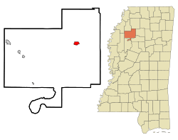
Location of Charleston, Mississippi
|
||
| Country | United States | |
| State | Mississippi | |
| County | Tallahatchie | |
| Area | ||
| • Total | 1.36 sq mi (3.52 km2) | |
| • Land | 1.35 sq mi (3.51 km2) | |
| • Water | 0.00 sq mi (0.01 km2) | |
| Elevation | 213 ft (65 m) | |
| Population
(2020)
|
||
| • Total | 1,884 | |
| • Density | 1,390.41/sq mi (536.81/km2) | |
| Time zone | UTC-6 (Central (CST)) | |
| • Summer (DST) | UTC-5 (CDT) | |
| ZIP codes |
38921, 38958
|
|
| Area code(s) | 662 | |
| FIPS code | 28-12900 | |
| GNIS feature ID | 2404031 | |
Charleston is a city in north central Mississippi. It is one of the two main towns, called county seats, for Tallahatchie County. This county is split by the Tallahatchie River. Charleston is located east of the river. In 2010, about 2,193 people lived here.
Contents
History of Charleston
Charleston became the main town (county seat) in 1837. The old main town, Old Tillatoba, had problems with its land ownership.
A school for girls, the Charleston Female School, opened in 1852. It was very popular for many years. A local newspaper, the Tallahatchie Herald, started in 1892. The Charleston Bank opened in 1901.
By the early 1900s, Charleston had important buildings. These included a brick courthouse and a jail. It also had three churches and several schools. There were also places for community groups, like a Masonic hall and an Odd Fellows lodge. Cotton farming was very important here, and the city had two cotton gins. In 1906, about 800 people lived in Charleston.
In 1931, a 4.6 magnitude earthquake happened in Charleston. This was the strongest earthquake ever recorded in Mississippi.
Geography and Location
Charleston covers about 1.4 square miles (3.5 square kilometers). Most of this area is land, with a small amount of water. The city is located where two Mississippi highways, Highway 32 and Highway 35, meet.
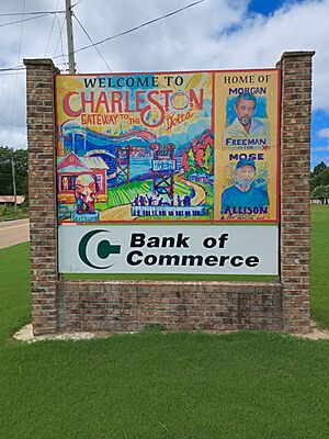
Charleston's official nickname is "Gateway to the Delta." This means it's seen as an entrance to the Mississippi Delta region.
People of Charleston
| Historical population | |||
|---|---|---|---|
| Census | Pop. | %± | |
| 1880 | 368 | — | |
| 1890 | 412 | 12.0% | |
| 1900 | 480 | 16.5% | |
| 1910 | 1,834 | 282.1% | |
| 1920 | 3,007 | 64.0% | |
| 1930 | 2,014 | −33.0% | |
| 1940 | 2,100 | 4.3% | |
| 1950 | 2,629 | 25.2% | |
| 1960 | 2,528 | −3.8% | |
| 1970 | 2,821 | 11.6% | |
| 1980 | 2,878 | 2.0% | |
| 1990 | 2,328 | −19.1% | |
| 2000 | 2,198 | −5.6% | |
| 2010 | 2,193 | −0.2% | |
| 2020 | 1,884 | −14.1% | |
| U.S. Decennial Census | |||
Population in 2020
In 2020, there were 1,884 people living in Charleston. There were 792 households and 514 families.
| Race | Num. | Perc. |
|---|---|---|
| White | 425 | 22.56% |
| Black or African American | 1,413 | 75.0% |
| Asian | 4 | 0.21% |
| Other/Mixed | 26 | 1.38% |
| Hispanic or Latino | 16 | 0.85% |
Education in Charleston
The East Tallahatchie School District serves the city of Charleston. Before 1970, schools were separate for different groups of students. In 1970, a court decision said that schools must be integrated. The school district then tried a plan where classes were still separate, but students and teachers were moved between schools during the day.
Students protested this plan. After some discussions, the students were allowed to return to school. Classrooms became integrated, and new student leaders were chosen.
Charleston High School held its first racially integrated prom in April 2008. This event was featured in a 2008 HBO documentary called Prom Night in Mississippi. The documentary showed the efforts to have one prom for all students, instead of separate ones.
Strider Academy, a school near the city, closed in 2018. Coahoma Community College is the local community college for students after high school.
Famous People from Charleston
Many notable people have connections to Charleston:
- Mose Allison – A famous blues singer and pianist.
- Eldra Buckley – A former running back for the NFL's Detroit Lions.
- Brad Dye – A former lieutenant governor of Mississippi.
- Morgan Freeman – An Academy Award-winning actor who lives in Charleston.
- Deantre Prince – A cornerback for the NFL's Jacksonville Jaguars.
- Jamie Whitten – A well-known congressman.
See also
 In Spanish: Charleston (Misisipi) para niños
 | Roy Wilkins |
 | John Lewis |
 | Linda Carol Brown |


