Yalobusha County, Mississippi facts for kids
Quick facts for kids
Yalobusha County
|
|
|---|---|

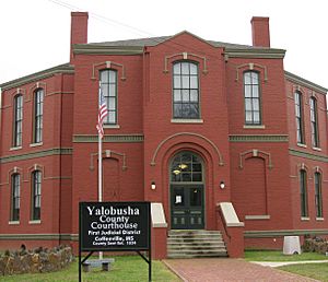
Yalobusha County Courthouse in Coffeeville
|
|

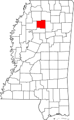
Location within the U.S. state of Mississippi
|
|
 Mississippi's location within the U.S. |
|
| Country | |
| State | |
| Founded | February 21, 1834 |
| Seat | Coffeeville and Water Valley |
| Largest city | Water Valley |
| Area | |
| • Total | 495 sq mi (1,280 km2) |
| • Land | 467 sq mi (1,210 km2) |
| • Water | 28 sq mi (70 km2) 5.6% |
| Population
(2020)
|
|
| • Total | 12,481 |
| • Density | 25.214/sq mi (9.735/km2) |
| Time zone | UTC−6 (Central) |
| • Summer (DST) | UTC−5 (CDT) |
| Congressional district | 2nd |
Yalobusha County (/ˈjælæˌbʊʃə/ YA-la-BUUSH-ə) is a county in Mississippi. In 2020, its population was 12,481. It has two county seats: Water Valley and Coffeeville.
Contents
History of Yalobusha County
The name Yalobusha comes from a Native American word. It likely means "tadpole place." This area was once home to the Choctaw and Chickasaw tribes.
In 1816, a line was drawn between the lands of the Choctaw and Chickasaw. This line cut across what is now Yalobusha County. Later, in the 1830s, both tribes signed treaties. They agreed to move to new lands in what is now Indian Territory (present-day Oklahoma).
In 1833, the Mississippi Legislature created 17 new counties. Yalobusha was one of them. These counties were formed on land that had belonged to Native American tribes.
Yalobusha County officially started on February 21, 1834. Its first leaders were elected then. They met in Hendersonville, which was the largest town at the time. Hendersonville was founded in 1798 by John Henderson.
The county leaders looked for a place for the county seat. They chose a spot and named it Coffeeville. This honored General John Coffee. He had helped with the treaties with the Choctaw and Chickasaw. The first courthouse in Coffeeville was built in 1837.
Around the same time, G. B. Ragsdale started a stagecoach stop. This was near where Water Valley is today. In 1848, the town of Oakland, Mississippi was officially started there.
In 1840, Yalobusha County had 12,248 people. Three years later, the post office and stagecoach stop moved. The new location was named Water Valley.
James K. Polk was a U.S. president from 1845 to 1849. He owned a cotton farm south of Coffeeville starting in 1835. After he died, his wife managed the farm before selling it.
By 1850, the county's population grew to 17,258. In 1852, parts of Yalobusha County were used to create Calhoun County.
The Illinois Central Railroad built a line through Water Valley and Coffeeville in the late 1850s. The railroad wanted to build repair shops in Coffeeville. But they couldn't get the land they needed. Water Valley offered to donate land to the railroad.
Because of this, the railroad shops were built in Water Valley. This brought many workers and businesses to the town. Water Valley quickly became the largest town in the county. It was officially chartered in 1858.
Water Valley grew into a busy community. It had hotels and churches. The first church was the Presbyterian Church, built in 1843. By 1860, the county's population was 16,952.
During the American Civil War, Water Valley was an important railroad town. On December 5, 1862, a small battle happened near Coffeeville. It was called the Battle of Coffeeville.
After the war, the railroad shops were built in Water Valley. This brought even more people to the town. In 1867, Yacona Mills started in Yalobusha County. It became the world's largest maker of twine.
In 1870, Grenada County was formed. It took some southern parts of Yalobusha County.
In 1873, Yalobusha County was divided into two court districts. Water Valley became the county seat for the second district. The town of Tillatoba was also chartered in 1873.
In 1889, the Coffeeville courthouse burned down. A new one was built in 1890. In 1893, the famous railroad engineer Casey Jones moved to Water Valley. He later moved back to Jackson, Tennessee, in 1896.
A new courthouse was built in Water Valley in 1896. It later burned down by accident. The offices moved to City Hall, but that also burned down. The courthouse was rebuilt after the fire.
Yalobusha County's population was highest in 1910, with 21,519 people. By 1920, it had dropped to 18,738. This was partly because of changes in farming. Also, many African Americans moved north during the Great Migration. They sought better opportunities and to escape unfair rules in the South. The population kept going down for 50 years.
Between 1926 and 1928, the county faced tough times. In 1926, the Yacona Twine Mill burned down. It had employed about 450 people. The next year, the railroad started moving its shops from Water Valley. By 1928, the shops were completely closed. They had once employed over 800 people.
In 1931, Water Valley held its first Watermelon Carnival. It was a huge success, bringing 20,000 visitors. Water Valley called itself the "Watermelon Capital of the World." The carnival stopped during World War II. It started again in 1980 and is now held every August.
After WWII, there was not much industry left. By 1950, the population was 15,191. In the 1950s, the U.S. Army Corps of Engineers built two flood control lakes. These were Enid Lake and Grenada Lake. They are now popular places for fun activities.
Yalobusha County's population was 12,502 in 1960. It was 11,915 in 1970. But in 1980, it grew to 13,139. Since the 1960s, new businesses have come to the county. Today, the two largest employers have over 2,000 workers.
Geography of Yalobusha County
The county covers 495 square miles (1,282 km²). About 467 square miles (1,210 km²) is land. The rest, 28 square miles (73 km²), is water.
Major Highways
 Interstate 55
 U.S. Highway 51
 Mississippi Highway 7
 Mississippi Highway 32
 Mississippi Highway 315
Neighboring Counties
- Lafayette County (northeast)
- Calhoun County (east)
- Grenada County (south)
- Tallahatchie County (west)
- Panola County (northwest)
Protected Areas
- Holly Springs National Forest (part)
Population Data
| Historical population | |||
|---|---|---|---|
| Census | Pop. | %± | |
| 1840 | 12,248 | — | |
| 1850 | 17,258 | 40.9% | |
| 1860 | 16,952 | −1.8% | |
| 1870 | 13,254 | −21.8% | |
| 1880 | 15,649 | 18.1% | |
| 1890 | 16,629 | 6.3% | |
| 1900 | 19,742 | 18.7% | |
| 1910 | 21,519 | 9.0% | |
| 1920 | 18,738 | −12.9% | |
| 1930 | 17,750 | −5.3% | |
| 1940 | 18,387 | 3.6% | |
| 1950 | 15,191 | −17.4% | |
| 1960 | 12,502 | −17.7% | |
| 1970 | 11,915 | −4.7% | |
| 1980 | 13,139 | 10.3% | |
| 1990 | 12,033 | −8.4% | |
| 2000 | 13,051 | 8.5% | |
| 2010 | 12,678 | −2.9% | |
| 2020 | 12,481 | −1.6% | |
| 2023 (est.) | 12,386 | −2.3% | |
| U.S. Decennial Census 1790-1960 1900-1990 1990-2000 2010-2013 |
|||
2020 Census Information
In 2020, there were 12,481 people living in Yalobusha County. There were 5,181 households and 3,350 families.
| Race | Number | Percentage |
|---|---|---|
| White (not Hispanic) | 7,331 | 58.74% |
| Black or African American (not Hispanic) | 4,615 | 36.98% |
| Native American | 24 | 0.19% |
| Asian | 21 | 0.17% |
| Pacific Islander | 2 | 0.02% |
| Other/Mixed | 325 | 2.6% |
| Hispanic or Latino | 163 | 1.31% |
Communities in Yalobusha County
City
- Water Valley (one of the county seats)
Towns
- Coffeeville (one of the county seats)
- Oakland
- Tillatoba
Unincorporated Communities
Ghost Towns
Notable People from Yalobusha County
- James K. Polk – He later became a U.S. president. He lived on a farm south of Coffeeville from 1835.
- Don Briscoe – An actor who appeared on TV shows (1940–2004).
See also
 In Spanish: Condado de Yalobusha para niños
 | Jewel Prestage |
 | Ella Baker |
 | Fannie Lou Hamer |


