Calhoun County, Mississippi facts for kids
Quick facts for kids
Calhoun County
|
|
|---|---|

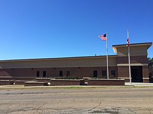
East façade of Calhoun County Courthouse in Pittsboro
|
|

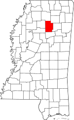
Location within the U.S. state of Mississippi
|
|
 Mississippi's location within the U.S. |
|
| Country | |
| State | |
| Founded | 1852 |
| Named for | John C. Calhoun |
| Seat | Pittsboro |
| Largest town | Bruce |
| Area | |
| • Total | 588 sq mi (1,520 km2) |
| • Land | 587 sq mi (1,520 km2) |
| • Water | 1.4 sq mi (4 km2) 0.2% |
| Population
(2020)
|
|
| • Total | 13,266 |
| • Density | 22.561/sq mi (8.711/km2) |
| Time zone | UTC−6 (Central) |
| • Summer (DST) | UTC−5 (CDT) |
| Congressional district | 1st |
Calhoun County is a place in the state of Mississippi, in the United States. It's like a special district within the state. In 2020, about 13,266 people lived here. The main town where the county government is located is called Pittsboro. The county got its name from John C. Calhoun, who was a very important leader from South Carolina. He was even a U.S. Vice President!
Contents
About Calhoun County
Calhoun County was created in 1852. It is named after John C. Calhoun, a famous American politician. He served as the Vice President of the United States. He was also a U.S. Senator for South Carolina.
Where is Calhoun County?
Calhoun County is located in Mississippi. It covers a total area of about 588 square miles. Most of this area is land, about 587 square miles. A small part, about 1.4 square miles, is water.
Neighboring Counties
Calhoun County shares its borders with several other counties. These are like its neighbors:
- Lafayette County (to the north)
- Pontotoc County (to the northeast)
- Chickasaw County (to the east)
- Webster County (to the south)
- Grenada County (to the southwest)
- Yalobusha County (to the west)
Getting Around
Calhoun County has important roads and an airport. These help people travel and move goods.
Main Roads
Several state highways pass through Calhoun County:
Airport
The Calhoun County Airport is a public airport. It is owned by the county. The airport is located about 1 mile southwest of Pittsboro, Mississippi. This makes it easy for people to fly in and out of the area.
People of Calhoun County
The number of people living in Calhoun County has changed over time. Here's a look at the population counts from different years:
| Historical population | |||
|---|---|---|---|
| Census | Pop. | %± | |
| 1860 | 9,518 | — | |
| 1870 | 10,561 | 11.0% | |
| 1880 | 13,492 | 27.8% | |
| 1900 | 16,512 | — | |
| 1910 | 17,726 | 7.4% | |
| 1920 | 16,823 | −5.1% | |
| 1930 | 18,080 | 7.5% | |
| 1940 | 20,893 | 15.6% | |
| 1950 | 18,369 | −12.1% | |
| 1960 | 15,941 | −13.2% | |
| 1970 | 14,623 | −8.3% | |
| 1980 | 15,664 | 7.1% | |
| 1990 | 14,908 | −4.8% | |
| 2000 | 15,069 | 1.1% | |
| 2010 | 14,962 | −0.7% | |
| 2020 | 13,266 | −11.3% | |
| 2023 (est.) | 12,685 | −15.2% | |
| U.S. Decennial Census 1790-1960 1900-1990 1990-2000 2010-2013 |
|||
Population in 2020
In 2020, the 2020 United States Census counted 13,266 people in Calhoun County. There were 5,846 households. Also, 3,752 families lived in the county.
The people living in Calhoun County come from different backgrounds:
| Race | Num. | Perc. |
|---|---|---|
| White | 8,662 | 65.29% |
| Black or African American | 3,444 | 25.96% |
| Native American | 15 | 0.11% |
| Asian | 17 | 0.13% |
| Other/Mixed | 381 | 2.87% |
| Hispanic or Latino | 747 | 5.63% |
Schools in Calhoun County
Education is important in Calhoun County. There are public high schools in Bruce, Calhoun City, and Vardaman.
There is also a private school called Calhoun Academy. It teaches students from kindergarten through 12th grade. This school is located between Pittsboro and Calhoun City. It serves students from Calhoun County and nearby areas.
Each school has its own special mascot:
- Calhoun Academy's mascot is the Cougar.
- Bruce's mascot is a Trojan.
- Calhoun City's mascot is a Wildcat.
- Vardaman's mascot is a Ram.
Towns and Communities
Calhoun County has several towns and smaller communities.
Towns
Villages
- Big Creek
- Pittsboro (This is the county seat, where the main government offices are.)
- Slate Springs
Unincorporated Communities
These are smaller places that are not officially towns or villages:
Old Towns
Some communities that used to exist are now called "ghost towns."
See also
 In Spanish: Condado de Calhoun (Misisipi) para niños
 | Stephanie Wilson |
 | Charles Bolden |
 | Ronald McNair |
 | Frederick D. Gregory |

