Webster County, Mississippi facts for kids
Quick facts for kids
Webster County
|
|
|---|---|

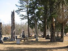
Cemetery of Greensboro Baptist Church in Webster County. The large white marble tombstone marks the grave of William F. Brantley, General, C.S.A.
|
|

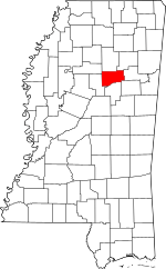
Location within the U.S. state of Mississippi
|
|
 Mississippi's location within the U.S. |
|
| Country | |
| State | |
| Founded | 1874 |
| Named for | Daniel Webster |
| Seat | Walthall |
| Largest city | Eupora |
| Area | |
| • Total | 423 sq mi (1,100 km2) |
| • Land | 421 sq mi (1,090 km2) |
| • Water | 2.3 sq mi (6 km2) 0.5% |
| Population
(2020)
|
|
| • Total | 9,926 |
| • Density | 23.466/sq mi (9.060/km2) |
| Time zone | UTC−6 (Central) |
| • Summer (DST) | UTC−5 (CDT) |
| Congressional district | 1st |
Webster County is a county located in the middle of the U.S. state of Mississippi. The Big Black River forms its southern border. In 2020, about 9,926 people lived here.
The county was created in 1874. This was during the Reconstruction era, a time after the American Civil War. Lawmakers named the county after Daniel Webster, a famous statesman from Massachusetts. The main town, or county seat, is Walthall. It was chosen in 1876.
For many years, Webster County was known as a "dry county." This meant that selling alcohol was not allowed. However, in 2018, a new law was passed. It now allows alcohol to be transported through dry counties in Mississippi.
Contents
History of Webster County
Webster County was officially formed in 1874. It was created from parts of nearby counties. These included Montgomery, Chickasaw, Choctaw, and Oktibbeha counties. The Big Black River makes up its southern edge. This river flows into the Mississippi River.
Long ago, the land was part of much larger areas. These areas were called Choctaw and Oktibbeha counties. As more people moved in, these big counties were divided. This created smaller counties like Webster. The land itself was bought by the United States in 1833. It was purchased from the Choctaw people in the Treaty of Dancing Rabbit Creek.
After the Choctaw people moved, settlers from other states came to this area. They came from Alabama, Georgia, and South Carolina. They also brought enslaved African Americans with them. These enslaved people were forced to work on farms.
Greensboro: The First County Seat
Greensboro was the first county seat for this area. At first, a simple courthouse and jail were built from logs. Later, in 1839, a brick courthouse and jail were built. Sadly, this courthouse burned down in 1865. Most of the old county records were lost in the fire.
In its early days, Greensboro was a busy town. It had many stores and shops. It was a trading center for the farms around it. There were also churches, like a Methodist church from 1839 and a Baptist church from 1846. A group called the Free and Accepted Masons also had a lodge there.
Greensboro was known as a frontier town. It was sometimes seen as a rough place. Famous people, like Jefferson Davis, visited Greensboro. He came in 1851 to ask for votes when he was running for governor.
The Civil War and After
When the American Civil War started in 1861, young men from Greensboro joined the army. One of the first groups was the Wigfall Rifles. This group was led by Captain William F. Brantley. He later became one of the youngest generals for the Southern states. In December 1864, Union soldiers raided Greensboro. They burned down much of the town.
After the war, General Brantley returned to Greensboro. He worked as a lawyer. This time after the war was called the Reconstruction era. It was a time of big changes and sometimes trouble.
In 1872, the state government decided to move the county seat. It moved from Greensboro to La Grange (historical), Mississippi. Then, in 1874, Webster County was officially formed. Greensboro was named its first county seat again. But in 1876, the county seat moved once more. It moved to Walthall, which was more in the center of the county.
After the county seat moved, Greensboro became much smaller. Many people and businesses left. They moved to the new county seat.
From the 20th Century to Today
For many years, Webster County was a "dry county." This meant that selling alcohol was not allowed. Police in Mathiston, Mississippi would often stop cars. They would search for and take any alcohol being carried through the county. But on July 1, 2018, a new law changed this. Now, people 21 and older can transport alcohol through dry counties in Mississippi.
Geography of Webster County
Webster County covers about 423 square miles. Most of this area, about 421 square miles, is land. The rest, about 2.3 square miles, is water.
Main Roads
 U.S. Highway 82
 Mississippi Highway 9
 Mississippi Highway 15
 Mississippi Highway 46
 Mississippi Highway 50
- Natchez Trace Parkway
Neighboring Counties
Webster County shares borders with these counties:
- Calhoun County (north)
- Chickasaw County (northeast)
- Clay County (east)
- Oktibbeha County (southeast)
- Choctaw County (south)
- Montgomery County (west)
- Grenada County (northwest)
Protected Areas
Part of the Natchez Trace Parkway is located in Webster County. This is a special area protected by the government.
Population Information
| Historical population | |||
|---|---|---|---|
| Census | Pop. | %± | |
| 1880 | 9,534 | — | |
| 1890 | 12,060 | 26.5% | |
| 1900 | 13,619 | 12.9% | |
| 1910 | 14,853 | 9.1% | |
| 1920 | 12,644 | −14.9% | |
| 1930 | 12,128 | −4.1% | |
| 1940 | 14,160 | 16.8% | |
| 1950 | 11,607 | −18.0% | |
| 1960 | 10,580 | −8.8% | |
| 1970 | 10,047 | −5.0% | |
| 1980 | 10,300 | 2.5% | |
| 1990 | 10,222 | −0.8% | |
| 2000 | 10,294 | 0.7% | |
| 2010 | 10,253 | −0.4% | |
| 2020 | 9,926 | −3.2% | |
| 2023 (est.) | 9,988 | −2.6% | |
| U.S. Decennial Census 1790-1960 1900-1990 1990-2000 2010-2013 |
|||
2020 Census Details
In 2020, there were 9,926 people living in Webster County. There were 3,782 households and 2,687 families.
| Race | Number of People | Percentage |
|---|---|---|
| White (not Hispanic) | 7,691 | 77.48% |
| Black or African American (not Hispanic) | 1,782 | 17.95% |
| Native American | 14 | 0.14% |
| Asian | 13 | 0.13% |
| Pacific Islander | 1 | 0.01% |
| Other/Mixed | 270 | 2.72% |
| Hispanic or Latino | 155 | 1.56% |
Communities in Webster County
City
Towns
- Maben (mostly in Oktibbeha County)
- Mathiston (partly in Choctaw County)
Villages
Other Communities
- Alva
- Bellefontaine
- Clarkson
- Cumberland
- Dancy
- Embry
- Fame
- Hohenlinden
- Old Greensboro
- Pellez
- Sapa
- Spring Valley
- Ticky Bend
- Tomnolen
Education
The schools in Webster County are part of the Webster County School District.
See also
 In Spanish: Condado de Webster (Misisipi) para niños
 | James Van Der Zee |
 | Alma Thomas |
 | Ellis Wilson |
 | Margaret Taylor-Burroughs |

