Oktibbeha County, Mississippi facts for kids
Quick facts for kids
Oktibbeha County
|
|
|---|---|

|
|

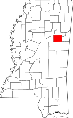
Location within the U.S. state of Mississippi
|
|
 Mississippi's location within the U.S. |
|
| Country | |
| State | |
| Founded | 1833 |
| Named for | The name Oktibbeha is a Native American word meaning either "Bloody water" (because of a battle fought on the banks) or possibly "Icy creek". |
| Seat | Starkville |
| Largest city | Starkville |
| Area | |
| • Total | 462 sq mi (1,200 km2) |
| • Land | 458 sq mi (1,190 km2) |
| • Water | 3.7 sq mi (10 km2) 0.8% |
| Population
(2020)
|
|
| • Total | 51,788 |
| • Density | 112.10/sq mi (43.28/km2) |
| Time zone | UTC−6 (Central) |
| • Summer (DST) | UTC−5 (CDT) |
| Congressional districts | 1st, 3rd |
Oktibbeha County is a place in the middle-eastern part of Mississippi. In 2020, about 51,788 people lived there. The main town, or county seat, is Starkville.
The name 'Oktibbeha' comes from the Choctaw language. It means 'icy creek'. The Choctaw people lived in this area for a very long time before Europeans arrived.
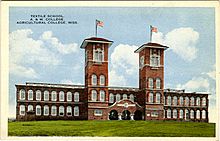
Mississippi State University, a big public university, is also in Oktibbeha County. It's a place where students learn and do important research. Oktibbeha County is part of a special area called the 'Golden Triangle' in Mississippi. This name is used for three counties working together to grow their economy.
Contents
History of Oktibbeha County
The name Oktibbeha is a Native American word. It means either "bloody water" (because of a battle) or "icy creek".
People have lived in this area for over 2,100 years! Old clay pot pieces and artwork have been found. These items date back to the Woodland period. There are also ancient earth mounds near Starkville. These mounds were built by early Native American groups.
The Choctaw people, one of the main Native American tribes in the Southeast, lived here for many centuries. The Indian Mound Campground nearby is named after these ancient earthworks.
Before the American Revolutionary War, the Chakchiuma tribe lived here. They were defeated by an alliance of the Choctaw and Chickasaw tribes.
Early Settlements and Starkville's Founding
White settlers started coming to the Starkville area because of two large springs. The Choctaw Agency was set up nearby. This agency helped deal with the Choctaw people and later sold land to new settlers.
The first settlement was called Boardtown. This was because a mill nearby made clapboards (wooden boards for buildings). In 1835, Boardtown became the county seat of Oktibbeha County. Its name was changed to Starkville. This new name honored General John Stark, a hero from the American Revolutionary War.
Mississippi State University was started near Starkville in 1878. It was a land-grant university, which means it received land from the government to build a college. Today, it is a major research university.
Since the late 1900s, Oktibbeha, Clay, and Lowndes counties have been called the Golden Triangle. They work together to help their economies grow. Because Mississippi State University has grown, Starkville is now the biggest city in this region.
Geography of Oktibbeha County
Oktibbeha County covers about 462 square miles. Most of this area is land (458 square miles), and a small part is water (3.7 square miles).
Most of the county is in the Black Belt region. This area is known for its dark, rich soil. Some parts of the county are also in the Flatwoods region.
Main Roads
Neighboring Counties
- Noxubee County (southeast)
- Winston County (south)
- Choctaw County (west)
- Webster County (northwest)
- Clay County (north)
- Lowndes County (east)
Protected Natural Areas
- Noxubee National Wildlife Refuge (part)
- Tombigbee National Forest (part)
Population Changes in Oktibbeha County
The number of people living in Oktibbeha County has changed over time. There was a big drop in population between 1910 and 1920. This was when many African Americans moved from the rural South to northern cities. They were looking for better jobs and opportunities.
| Historical population | |||
|---|---|---|---|
| Census | Pop. | %± | |
| 1840 | 4,276 | — | |
| 1850 | 9,171 | 114.5% | |
| 1860 | 12,977 | 41.5% | |
| 1870 | 14,891 | 14.7% | |
| 1880 | 15,978 | 7.3% | |
| 1890 | 17,694 | 10.7% | |
| 1900 | 20,183 | 14.1% | |
| 1910 | 19,676 | −2.5% | |
| 1920 | 16,872 | −14.3% | |
| 1930 | 19,119 | 13.3% | |
| 1940 | 22,151 | 15.9% | |
| 1950 | 24,569 | 10.9% | |
| 1960 | 26,175 | 6.5% | |
| 1970 | 28,752 | 9.8% | |
| 1980 | 36,018 | 25.3% | |
| 1990 | 38,375 | 6.5% | |
| 2000 | 42,902 | 11.8% | |
| 2010 | 47,671 | 11.1% | |
| 2020 | 51,788 | 8.6% | |
| 2023 (est.) | 51,203 | 7.4% | |
| U.S. Decennial Census 1790-1960 1900-1990 1990-2000 2010-2013 |
|||
2020 Census Information
The United States Census counts everyone living in the country every ten years. In 2020, Oktibbeha County had 51,788 people. There were 17,798 households and 9,263 families.
The population was made up of different groups:
- About 56.43% were White.
- About 35.2% were Black or African American.
- About 2.91% were Asian.
- About 2.82% were of other races or mixed races.
- About 2.45% were Hispanic or Latino (who can be of any race).
Education in Oktibbeha County
Oktibbeha County has one main school district now: the Starkville Oktibbeha Consolidated School District. This district was formed in 2013.
In the past, there were many small schools with just one teacher. Over time, these schools joined together to form larger ones.
History of Schools
Until 1970, schools in the county were separated by race. This was called segregation. Schools for African-American students often did not get as much money or resources.
In the 1920s, groups helped build better rural schools for African-American children. They used money from the Rosenwald Foundation. Eight of these "Rosenwald Schools" were built in the county between 1922 and 1927. The largest was the Oktibbeha County Training School, which opened in 1926.
From 1923 until 1970, African-American students attended schools on what is now Dr. Martin Luther King, Jr. Boulevard. These schools were known by different names, including Oktibbeha County Training School and Henderson High School.
In 1970, schools were integrated, meaning students of all races could attend the same schools. Henderson High School became a junior high school. The original Rosenwald School was destroyed in a fire. Today, Henderson-Ward Stewart Elementary is on that site.
In 2013, a state law combined all Oktibbeha County schools into the Starkville School District.
Private Schools
The county also has two private schools:
- Starkville Academy was started in 1969.
- Starkville Christian School was founded in 1995.
Higher Education
For college, students in Oktibbeha County can attend East Mississippi Community College. Also, Mississippi State University is located here. Its growth has helped Starkville become the largest city in the Golden Triangle area.
Public Libraries
The county also has a public library system called the Starkville-Oktibbeha County Public Library System.
Communities in Oktibbeha County
City
- Starkville (This is the county seat, the main town.)
Towns
- Maben (partly in Webster County)
- Sturgis
Census-Designated Places
These are areas that are like towns but are not officially incorporated as cities or towns.
Other Unincorporated Communities
These are small communities that are not officially part of a city or town.
- Adaton
- Bradley
- Clayton Village
- Hickory Grove
- Hickory Grove Estates
- Josey Creek
- Longview
- Morgantown
- Oktoc
- Osborn
- Self Creek
- Sessums
Historical and Ghost Towns
These are places that used to be communities but are no longer active or have very few people living there.
- Agency
- Bell's Mill
- Chapel
- Cedar Grove
- Collier's Tanyard
- Double Springs
- Ebenezer
- Folsom
- Grab All
- Hassie
- Kemper
- Lincecum's Mill
- Muldrow Station
- Prospect
- Red Acre
- Steelville
- Trimcane
- Whitefield
- Yanaby
See also
 In Spanish: Condado de Oktibbeha para niños
 | Kyle Baker |
 | Joseph Yoakum |
 | Laura Wheeler Waring |
 | Henry Ossawa Tanner |

