
National Register of Historic Places listings in Oktibbeha County, Mississippi facts for kids

Have you ever wondered about old buildings and places that are really important to history? In Oktibbeha County, Mississippi, there are many special spots listed on the National Register of Historic Places. This is like a special list kept by the United States government. It helps protect places that are important because of their history, architecture, or what happened there.
When a place is on this list, it means it's recognized as a valuable part of our country's story. It also helps people learn about and preserve these amazing sites for future generations. Oktibbeha County has 25 different places and areas on this list. Let's explore some of them!
Contents
Historic Homes and Buildings
Many of the places on the National Register in Oktibbeha County are old houses and buildings. These homes tell us a lot about how people lived long ago.
Beautiful Old Houses
- Bardwell House: This house was built around 1855. Imagine living in a house that's almost 170 years old! It's located on Blackjack Road in Starkville, Mississippi.
- Bell House: Another historic home in Starkville, the Bell House is found on Mississippi Highway 25.
- Thomas Battle Carroll House and Magruder-Newsom House: These two homes are both on South Jackson Street in Starkville. They are great examples of older architecture in the city.
- The Cedars: This historic property is on Old West Point Road in Starkville. It's a reminder of the past in the area.
- C. E. Gay House: Located on East Gillespie Street, this house is another important part of Starkville's history.
- Gillespie-Jackson House: This house is at the corner of Mississippi Highways 12 and 25. It's a landmark in Starkville.
- Lampkin-Owens House: You can find this historic home on North Montgomery Street.
- Meadow Woods Plantation House and Dossey A. Outlaw Plantation: These two plantation houses are on Oktoc Road. They show us what larger homes and farms were like in the past.
- Walker-Critz House: This house on Chapin Street is another example of the historic homes in Starkville.
Hotel Chester
The Hotel Chester is a very interesting building on East Main Street in Starkville. It was added to the National Register in 1985. Hotels like this were once very busy places. They welcomed travelers and were often important centers for the community.
University Buildings
Mississippi State University in Starkville has some historic buildings on its campus.
- Montgomery Hall: Built between 1902 and 1903, this building uses a style called Beaux-Arts architecture. It's a grand and impressive building on the university campus.
- Textile Building: This building was constructed in 1900. It's one of the oldest academic buildings at Mississippi State University. It shows a mix of architectural styles, including Italianate and Romanesque.
Historic Districts and Sites
Besides individual buildings, some entire areas or special sites are also on the National Register. These are called historic districts or archaeological sites.
Starkville's Historic Districts
- Downtown Starkville Historic District: This area includes many important buildings in the heart of Starkville. It's roughly bounded by Jefferson, North Montgomery, and Yeates Streets, and the railroad tracks. It was added to the list in 2012.
- Greensboro Street Historic District: This district covers Greensboro Street and nearby areas. It was recognized in 1982 and later expanded in 2008. It's a great place to see many historic buildings together.
- Nash Street Historic District: This district includes parts of University Drive and North Nash Street. It was listed in 1993.
- Overstreet School Historic District: This district is roughly bordered by Hogan, Montgomery, Gillespie, Jackson, Wood, and Washington Streets, and the Illinois Central railroad tracks. It includes the area around the historic Overstreet School.
Important Sites
- Herman Mound and Village Site: This site is a very old place where Native American people once lived. It includes a mound and the remains of a village. Places like this help us learn about the earliest people in Mississippi.
- Lyon's Bluff Site: Another ancient site, Lyon's Bluff is also a place where early communities lived. These sites are often protected to preserve important archaeological findings.
Historic Cemeteries
Cemeteries can also be historic places, telling us about the people who lived in an area.
- Odd Fellows Cemetery: Located at the junction of U.S. Route 82 and Henderson Street, this cemetery was added to the list in 1990.
- Starkville Colored Cemetery: This cemetery is on the north side of University Drive. It was listed in 2014 and is an important site for local history.
John M. Stone Cotton Mill
The John M. Stone Cotton Mill on Gillespie Street is another significant listing. Cotton mills were very important in the history of Mississippi and the South. They were big factories where cotton was turned into fabric. This mill shows us about the industrial past of the region.
Images for kids
-
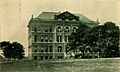
Montgomery Hall at Mississippi State University
-
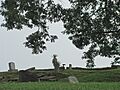
Odd Fellows Cemetery in Starkville
-
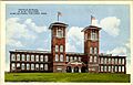
The historic Textile Building at Mississippi State University


