
Crenshaw, Mississippi facts for kids
Quick facts for kids
Crenshaw, Mississippi
|
|
|---|---|
 |
|

Location of Crenshaw, Mississippi
|
|

Crenshaw, Mississippi
Location in the United States
|
|
| Country | United States |
| State | Mississippi |
| Counties | Panola, Quitman |
| Area | |
| • Total | 0.41 sq mi (1.06 km2) |
| • Land | 0.41 sq mi (1.06 km2) |
| • Water | 0.00 sq mi (0.00 km2) |
| Elevation | 187 ft (57 m) |
| Population
(2020)
|
|
| • Total | 638 |
| • Density | 1,552.31/sq mi (599.36/km2) |
| Time zone | UTC-6 (Central (CST)) |
| • Summer (DST) | UTC-5 (CDT) |
| ZIP code |
38621
|
| Area code(s) | 662 |
| FIPS code | 28-16460 |
| GNIS feature ID | 2406335 |
Crenshaw is a town in the state of Mississippi, USA. It's unique because it's located in two different counties: Panola County and Quitman County. According to the 2020 United States Census, 638 people call Crenshaw home.
Contents
A Look Back: Crenshaw's History
Crenshaw started as a town along the Yazoo and Mississippi Valley Railroad. This railroad was very important for travel and trade.
In the early 1900s, Crenshaw grew quite a bit. It had its own post office and several stores. There were also churches and schools for the community. A special building housed both an oil mill and a cotton gin. These were key for processing crops. The town's bank was established in 1905.
Where is Crenshaw Located?
Crenshaw is mostly in Panola County. A smaller part of the town is in Quitman County.
In the year 2000, most of Crenshaw's residents lived in Panola County. About 76% of the town's 916 people lived there. The remaining 24% lived in Quitman County. The town covers a total area of about 0.4 square miles (1.1 square kilometers). All of this area is land.
Crenshaw's Population Over Time
| Historical population | |||
|---|---|---|---|
| Census | Pop. | %± | |
| 1910 | 358 | — | |
| 1920 | 512 | 43.0% | |
| 1930 | 575 | 12.3% | |
| 1940 | 623 | 8.3% | |
| 1950 | 740 | 18.8% | |
| 1960 | 1,382 | 86.8% | |
| 1970 | 1,271 | −8.0% | |
| 1980 | 1,019 | −19.8% | |
| 1990 | 978 | −4.0% | |
| 2000 | 916 | −6.3% | |
| 2010 | 885 | −3.4% | |
| 2020 | 638 | −27.9% | |
| U.S. Decennial Census | |||
Who Lives in Crenshaw? (2020 Census)
The 2020 United States Census counted 638 people living in Crenshaw. There were 351 households and 239 families in the town.
The census also looked at the different groups of people living there:
| Race | Number of People | Percentage |
|---|---|---|
| White | 137 | 21.47% |
| Black or African American | 492 | 77.12% |
| Native American | 1 | 0.16% |
| Other/Mixed | 6 | 0.94% |
| Hispanic or Latino | 2 | 0.31% |
Crenshaw's Population in 2010
In the 2010 United States Census, 885 people lived in Crenshaw. Most residents, about 77.2%, were African American. About 21.6% were White. A small number were Native American (0.1%). About 0.8% were from other races, and 0.3% were from two or more races. People who identified as Hispanic or Latino made up 0.8% of the population.
Getting Around: Transportation
The City of New Orleans is a famous Amtrak train. It travels between New Orleans and Chicago. This train passes through Crenshaw on CN tracks. However, the train does not stop in Crenshaw. The closest train station is in Marks. Marks is about 19 miles (31 km) south of Crenshaw.
Learning in Crenshaw: Education
Students in the Panola County part of Crenshaw attend schools in the North Panola School District. Crenshaw Elementary School is right in town. North Panola Junior High School is in Como. North Panola High School is located in Sardis.
For students living in the Quitman County part of Crenshaw, they are served by the Quitman County School District.
Famous People From Crenshaw
Some notable people have come from Crenshaw:
- Gene Lambert was a professional baseball player.
- Marva Lee Pitchford-Jolly was a talented ceramicist. She was known for her beautiful pottery.
Images for kids
-
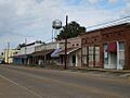
A view of Crenshaw, Mississippi.
-
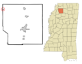
Map showing Crenshaw's location in Panola County, Mississippi.
See also
 In Spanish: Crenshaw para niños
