Piperton, Tennessee facts for kids
Quick facts for kids
Piperton, Tennessee
|
|
|---|---|
|
City
|
|
| Motto(s):
"A better community built on small town values"
|
|

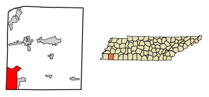
Location of Piperton in Fayette County, Tennessee.
|
|
| Country | United States |
| State | Tennessee |
| County | Fayette |
| Incorporated | 1974 |
| Area | |
| • Total | 27.32 sq mi (70.77 km2) |
| • Land | 27.20 sq mi (70.43 km2) |
| • Water | 0.13 sq mi (0.33 km2) |
| Elevation | 361 ft (110 m) |
| Population
(2020)
|
|
| • Total | 2,263 |
| • Density | 83.21/sq mi (32.13/km2) |
| Time zone | UTC-6 (Central (CST)) |
| • Summer (DST) | UTC-5 (CDT) |
| ZIP code |
38017 (Collierville)
|
| Area code(s) | 901 |
| FIPS code | 47-58840 |
| GNIS feature ID | 1297695 |
Piperton is a city located in Fayette County, Tennessee, in the United States. In 2020, the city had a population of 2,263 people. Piperton was officially established as a city in 1974.
Contents
Exploring Piperton's Location
Piperton is found in the southwestern part of Fayette County. It is close to other towns and states. To the west, it borders Collierville in Shelby County. To the east, you'll find Rossville. South of Piperton is Marshall County, Mississippi in the state of Mississippi.
According to the United States Census Bureau, Piperton covers a total area of about 70.7 square kilometers (27.3 square miles). Most of this area, about 70.4 square kilometers (27.2 square miles), is land. A small part, about 0.3 square kilometers (0.1 square miles), is water. The city's size grew a lot between 2000 and 2010.
Main Roads in Piperton
Several important roads pass through Piperton, connecting it to other places.
- U.S. Route 72 goes through the southern part of the city. It leads northwest to Collierville and then about 26 miles to downtown Memphis. If you go southeast on US 72, you will cross into Mississippi and reach Corinth, which is about 64 miles away.
- State Route 57 runs through the middle of Piperton. It goes west into Collierville and east about 25 miles to Grand Junction.
- State Route 196 crosses State Route 57 in the center of Piperton. It heads north about 21 miles to Gallaway. The southern end of State Route 196 is near US 72, close to the Mississippi border.
- State Route 385, also known as the Nonconnah or Bill Morris Parkway, is part of the Memphis outer beltway. It passes through the western side of Piperton and can be accessed from State Route 57.
- Interstate 269 has an exit where it meets State Route 385, right on the border between Piperton and Collierville. North of this exit, I-269 is the new name for the beltway. South of the exit, I-269 goes into Mississippi, with one exit in Piperton at US 72.
People Living in Piperton
The number of people living in Piperton has changed over the years. Here's how the population has grown:
| Historical population | |||
|---|---|---|---|
| Census | Pop. | %± | |
| 1980 | 746 | — | |
| 1990 | 612 | −18.0% | |
| 2000 | 589 | −3.8% | |
| 2010 | 1,445 | 145.3% | |
| 2020 | 2,263 | 56.6% | |
| Sources: | |||
Piperton's Population in 2020
In 2020, the 2020 United States Census counted 2,263 people living in Piperton. There were 807 households and 652 families in the city.
The census also collects information about the different backgrounds of people. Here's a look at the racial makeup of Piperton in 2020:
| Race | Number of People | Percentage |
|---|---|---|
| White | 1,695 | 74.9% |
| Black or African American | 401 | 17.72% |
| Native American | 3 | 0.13% |
| Asian | 41 | 1.81% |
| Pacific Islander | 1 | 0.04% |
| Other/Mixed | 70 | 3.09% |
| Hispanic or Latino | 52 | 2.3% |
See also
 In Spanish: Piperton para niños
 | Mary Eliza Mahoney |
 | Susie King Taylor |
 | Ida Gray |
 | Eliza Ann Grier |

