Hickory Valley, Tennessee facts for kids
Quick facts for kids
Hickory Valley, Tennessee
|
|
|---|---|

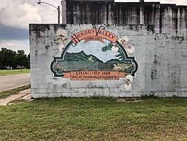
The mural in central Hickory Valley, 2019
|
|

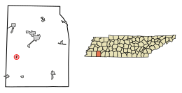
Location of Hickory Valley in Hardeman County, Tennessee.
|
|
| Country | United States |
| State | Tennessee |
| County | Hardeman |
| Incorporated | 1820 |
| Area | |
| • Total | 0.32 sq mi (0.82 km2) |
| • Land | 0.32 sq mi (0.82 km2) |
| • Water | 0.00 sq mi (0.00 km2) |
| Elevation | 564 ft (172 m) |
| Population
(2020)
|
|
| • Total | 78 |
| • Density | 246.06/sq mi (95.06/km2) |
| Time zone | UTC-6 (Central (CST)) |
| • Summer (DST) | UTC-5 (CDT) |
| ZIP code |
38042
|
| Area code(s) | 731 |
| FIPS code | 47-33920 |
| GNIS feature ID | 1287628 |
Hickory Valley is a small town in Hardeman County, Tennessee, United States. In 2020, about 78 people lived there. The town began when three early settlements joined together. These settlements were started by William Shinault in 1820, Drury Wood in 1826, and William Barnett in 1827.
Contents
History of Hickory Valley
Hickory Valley started when three separate pioneer settlements came together. These were founded by William Shinault in 1820, Drury Wood in 1826, and William Barnett in 1827.
Early Settlements
The Shinault Settlement was formed even before Hardeman County was officially set up. It had the first school in Hardeman County, which opened around 1823. The main buildings of this settlement were about a mile southwest of where the town is today. You can still see parts of an old Native American trail and the historic Boliver-LaGrange Road south of Hickory Valley.
In 1826, Drury Wood moved to the area and started the Hickory Valley settlement. There's still a cemetery for the Wood family there, which marks the original spot. William Barnett arrived in 1827. He built the Mt. Comfort Church and a campground about two miles west of the current town. The Chickasaw people also lived in this area.
Railroad and Growth
The town grew a lot when the railroad was built in the 1850s. You can still see a railroad levee (a raised path for the tracks) running through the town. It's thought that enslaved people from a plantation owned by Darius Robinson built this levee. A famous railroad engineer named Casey Jones often visited the town during his train travels.
Challenges and Revival
The Civil War greatly affected Hickory Valley. The Union Army took control of the railroad after the Confederate Army left it. Small battles also happened in the area.
In 1873, the town was planned out again and started to recover. However, a serious illness called yellow fever spread in 1878. Many people left the town to escape the sickness. In 1882, the town was also put under quarantine because of a smallpox outbreak.
Geography
Hickory Valley is located at 35°9′18″N 89°7′36″W / 35.15500°N 89.12667°W. It covers about 0.3 square miles (0.8 square kilometers) of land. There is no water area within the town limits.
Population Information
Hickory Valley has seen its population change over the years.
| Historical population | |||
|---|---|---|---|
| Census | Pop. | %± | |
| 1880 | 78 | — | |
| 1890 | 157 | 101.3% | |
| 1960 | 179 | — | |
| 1970 | 180 | 0.6% | |
| 1980 | 252 | 40.0% | |
| 1990 | 159 | −36.9% | |
| 2000 | 136 | −14.5% | |
| 2010 | 99 | −27.2% | |
| 2020 | 78 | −21.2% | |
| Sources: | |||
In 2000, there were 136 people living in Hickory Valley. The town had 59 households and 35 families. About 23.7% of households had children under 18. The average age of people in the town was 44 years old.
There are two churches in Hickory Valley that have been around for over 30 years: the Hickory Valley Methodist Church and the Hickory Valley Baptist Church.
Arts and Culture
Hickory Valley has buildings that date back to the Antebellum period, which means before the Civil War. The town still has a historic cotton gin that works. There's also a small business area that reminds people of when it was a busy railroad town.
Hickory Valley is special because it has the only remaining sassafras mill in the United States. This mill sits in front of City Hall. Locals built and owned the mill in the 1920s. The oil it made was sent all over the country. The James Monroe Avent House in Hickory Valley is a historic building. It was added to the National Register of Historic Places in 2001.
Transportation
Getting to and around Hickory Valley is mainly done by road. Tennessee State Route 18 is the main road that goes through the town. It runs from north to south.
The closest airport is William L. Whitehurst Field. It's located off State Route 18, between Hickory Valley and Bolivar, Tennessee. However, this airport doesn't have regular passenger flights. For commercial flights, people usually go to McKellar–Sipes Regional Airport or Memphis International Airport.
See also
 In Spanish: Hickory Valley para niños
 | May Edward Chinn |
 | Rebecca Cole |
 | Alexa Canady |
 | Dorothy Lavinia Brown |

