
White River (Arkansas–Missouri) facts for kids
Quick facts for kids White River |
|
|---|---|

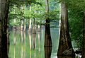
White River in Arkansas, January 2008
|
|

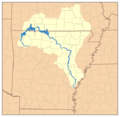
Map of the White River watershed
|
|
| Country | United States |
| State | Arkansas, Missouri |
| Cities | Newport, Batesville, Fayetteville |
| Physical characteristics | |
| Main source | Boston Mountains Ozark-St. Francis National Forest, Madison County, Arkansas 2,260 ft (690 m) 35°50′20″N 93°36′16″W / 35.83889°N 93.60444°W |
| River mouth | Mississippi River Desha County, Arkansas 188 ft (57 m) 33°57′5″N 91°4′53″W / 33.95139°N 91.08139°W |
| Length | 722 mi (1,162 km) |
| Discharge (location 2) |
|
| Basin features | |
| Basin size | 27,765 sq mi (71,910 km2) |
| Landmarks | White River National Wildlife Refuge |
| Tributaries |
|
| Waterbodies | Lake Taneycomo, Beaver Lake, Bull Shoals Lake, Table Rock Lake |
The White River is a long river, about 722 miles (1,162 km) long. It flows through the states of Arkansas and Missouri in the United States. The river starts in the Boston Mountains of northwest Arkansas. It then curves north into southern Missouri before turning back into Arkansas. Finally, it flows southeast until it reaches the Mississippi River.
About the River's Journey

Where the River Starts and Flows
The White River begins in the Boston Mountains of northwest Arkansas. This area is part of the Ozark–St. Francis National Forest, southeast of Fayetteville. From its start, the river flows north. It makes a big loop through southwest Missouri. After that, it heads southeast through Arkansas to join the Mississippi River.
When the river reaches the Mississippi River Valley near Batesville, Arkansas, it changes. Here, boats that don't need much water can travel on it. The river also slows down a lot. The last 10 miles (16 km) of the White River are part of a bigger waterway system. This part is deeper, helping ships move along.
How Much Water Flows
The White River is shorter than the Arkansas River. However, it carries almost as much water. Usually, more than 20,000 cubic feet (570 m³) of water flow per second. During floods, this can increase to over 100,000 cubic feet (2,800 m³) per second.
Controlling Floods and Creating Lakes
In the 1900s, people changed large parts of the White River. They built many dams to create artificial lakes. These lakes help control floods and generate electricity. They also help manage water and provide places for fun activities.
The first big lake you find from the river's start is Beaver Lake in northwest Arkansas. Next are Table Rock Lake and Lake Taneycomo in southern Missouri. Finally, there's Bull Shoals Lake as the river goes back into northern Arkansas. Below Bull Shoals Dam, the White River returns to its natural state. It flows southeast through the eastern Ozark-St. Francis National Forest.
Early Power from the River
In 1910, a company called Ozark Power and Water Company got permission to build a hydroelectric dam. This dam was built on the White River. It was finished in 1913 and cost $2.3 million. This dam, called Powersite Dam, is near Forsyth, Missouri. It created Lake Taneycomo. This project brought electricity to a rural part of the Ozark Mountains. Later, in the 1940s, more programs brought electricity to even more areas.
Lake Taneycomo also became a popular spot for fun. This brought tourists to places like Rockaway Beach and Branson. The Ozark Power and Electric Company later joined with Empire District Electric Company in 1927. They still own and run Powersite Dam today.
Lakes Built by the Army Corps of Engineers
Beaver Lake, Bull Shoals Lake, and Table Rock Lake are all man-made lakes. They were created by the U.S. Army Corps of Engineers. This was done under a law called the Flood Control Act of 1938.
Bull Shoals Dam is near Mountain Home, Arkansas. It was built from 1947 to 1951. It is the 5th largest concrete dam in the United States. This dam holds back Bull Shoals Lake. This is the biggest lake on the White River and the furthest downstream.
Next, Table Rock Dam was built near Branson, Missouri. It was finished in 1958. This dam created Table Rock Lake. It is the second largest lake on the White River. It is a very popular place for tourists near Branson.
Beaver Dam near Eureka Springs, Arkansas was built between 1960 and 1966. It created Beaver Lake. This is the dam and lake furthest upstream on the river.
In total, eight dams block the upper White River. Six are in Arkansas and two are in Missouri. The White River National Wildlife Refuge is located along the lower part of the river.
Main Rivers Joining the White River
Many smaller rivers and streams flow into the White River. These are called tributaries. Some of the main ones include Cache River, Bayou des Arc, Little Red River, Black River, North Fork River, Crooked Creek, Buffalo River, Kings River, James River, and Roaring River.
Towns and Cities Along the River
Arkansas
Missouri
Fishing in the White River
Fishing for trout is very popular in the upper parts of the river. This includes the waters below Beaver Lake in northwest Arkansas. It also covers the river's path through southwest Missouri, including all of Lake Taneycomo. The good fishing continues down through Arkansas to the Highway 58 bridge in Guion.
The White River has been known as one of the best places to fish for trout in the country. People enjoy catching different kinds of trout here. These include rainbow, brown, and cutthroat trout. Many fishing resorts for trout are found near Bull Shoals Lake and the North Fork River. Fishing for white bass is also popular in these waters.
Images for kids
-
White River in Arkansas, January 2008
-
Map of the White River watershed
-
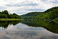
White River near Flippin, Arkansas, May 2006
See also
 In Spanish: Río Blanco (Arkansas) para niños
