Kings River (Arkansas) facts for kids
Quick facts for kids Kings River |
|
|---|---|

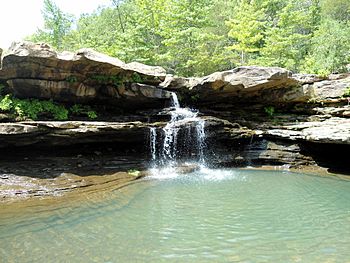
Kings River Falls within the Kings River Natural Area, Madison County, Arkansas
|
|
| Country | United States |
| State | Arkansas and Missouri |
| Physical characteristics | |
| Main source | Madison County, Arkansas 2,270 ft (690 m) 35°50′00″N 93°34′50″W / 35.83333°N 93.58056°W |
| River mouth | Table Rock Lake, Carroll County, Arkansas 915 ft (279 m) 36°29′29″N 93°34′40″W / 36.49139°N 93.57778°W (confluence with Table Rock Lake waters in northern Carroll County, Arkansas) |
The Kings River is a cool river that flows through Arkansas and Missouri. It starts high up in the Boston Mountains of Arkansas. From there, it travels north for over 90 miles. Eventually, it flows into Table Rock Lake, which is in Missouri.
This river is special because it doesn't have any dams. It's surrounded by beautiful forests and countryside. Many people love to go paddling and fishing here. It's a great place to enjoy nature!
Contents
The River's Journey: Course of the Kings River
The Kings River begins in the Boston Mountains of Arkansas. Its highest points are more than 2,000 feet (610 meters) above sea level. These starting points are found in the Ozark–St. Francis National Forest.
The river flows generally north through a special area called the Kings River Falls Natural Area. It passes under Arkansas Highway 74 and near the town of Kingston. The river then turns northwest.
It continues its journey, passing under U.S. Route 412 near Marble. As it flows, it forms part of the border between Madison and Carroll counties. The river then enters Carroll County.
Further north, the Kings River goes under U. S. Route 62 near Berryville. It also passes under Arkansas Highway 143 south of Grandview. Finally, it reaches Table Rock Lake at the Missouri state line.
The river's path is quite winding, but it generally flows north. It drains an area of about 591 square miles (1,531 square kilometers). The river ends when it flows into Table Rock Lake. This lake is a reservoir on the White River.
The town of Berryville is the only city in the river's watershed. Near Berryville, the Kings River flows with an average of 572 cubic feet of water per second. This measurement is based on data from 1935 to 2008.
Several smaller streams flow into the Kings River. These are called tributaries. Some of them include Felkins Creek, Maxwell Creek, Pine Creek, Dry Fork Creek, and Osage Creek.
A Look Back: History of the Kings River Area
Long ago, the Kings River area was a hunting ground. The Osage Native American tribe used to hunt here.
The river is said to be named after a man named Henry King. He was from Alabama and explored the Boston Mountains. He died and was buried near the river's banks. Soon after, other families from Alabama settled in the area.
However, an old newspaper article from 1823 already mentioned the Kings River. This suggests the name might have been used even earlier.
Around 1940, raising chickens became a big industry in the region. This changed how people made a living. In 1951, the U.S. Army Corps of Engineers suggested building a dam on the Kings River. But the dam was never built. This makes the Kings River one of the few rivers in the Ozark region that doesn't have a dam.
Protecting and Enjoying the Kings River
The state of Arkansas calls the Kings River an "Extraordinary Resource Waterbody." This special name means the river is very important. It helps protect the river from changes and pollution.
Arkansas describes the river as "clear and cool." It starts in the steep Boston Mountains. In its upper parts, the Kings River cuts through rock, forming a narrow gorge. Further downstream, the land becomes less steep.
Kings River Natural Area
The Kings River Natural Area was created in 1979. It's located on the upper part of the river, near Boston. This area covers about 1,059 acres (429 hectares).
It has a two-mile hiking trail that leads to the beautiful Kings River Falls. This is a scenic waterfall about 6 feet (2 meters) high. The Natural Area is in a rugged mountain region. The slopes are covered with different types of forests.
Wildlife and Conservation Efforts
The McIlroy Madison County Wildlife Management Area is another protected place. It includes several miles along the Kings River. In 2010, the Nature Conservancy also set up a preserve. This preserve covers 4,561 acres (1,846 hectares) and includes seven miles of river frontage. These efforts help protect the river and its surrounding nature.
Fun on the Water: Recreation
People who love to paddle divide the Kings River into two main parts. The upper section is about eleven miles long. It's a "Class III whitewater" stream. This means it has turbulent water and rapids. This section includes the waterfall at the Kings River Natural Area. It's usually good for paddling in winter and spring.
The lower Kings River is much longer, about 82.5 miles. This part is a "Class I" stream, which means it's much gentler. It usually has enough water for floating in winter, spring, and early summer. It can also be floated after heavy rains.
The Kings River is also a great place for fishing. Many people enjoy catching smallmouth bass and other types of fish here.
 | Anna J. Cooper |
 | Mary McLeod Bethune |
 | Lillie Mae Bradford |

