Augusta, Arkansas facts for kids
Quick facts for kids
Augusta, Arkansas
|
|
|---|---|

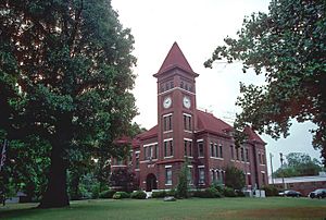
Woodruff County courthouse in Augusta
|
|

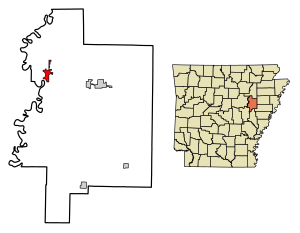
Location of Augusta in Woodruff County, Arkansas.
|
|
| Country | United States |
| State | Arkansas |
| County | Woodruff |
| Founded | 1848 |
| Incorporated | July 9, 1860 |
| Named for | Founder Thomas Hough's niece, Augusta Cald |
| Area | |
| • Total | 2.09 sq mi (5.41 km2) |
| • Land | 2.07 sq mi (5.37 km2) |
| • Water | 0.02 sq mi (0.04 km2) |
| Elevation | 217 ft (66 m) |
| Population
(2020)
|
|
| • Total | 1,998 |
| • Density | 964.29/sq mi (372.25/km2) |
| Time zone | UTC−06:00 (Central (CST)) |
| • Summer (DST) | UTC−05:00 (CDT) |
| ZIP Code |
72006
|
| Area code(s) | 870 |
| FIPS code | 05-02740 |
| GNIS feature ID | 2403137 |
Augusta is a city in Woodruff County, Arkansas, United States. It is located on the east side of the White River. In 2020, about 1,998 people lived there. Augusta is also the county seat of Woodruff County, meaning it's where the county government is located.
Contents
History of Augusta
Augusta was a great spot for riverboats because of its location on the White River. After the American Civil War, the town grew a lot in the 1870s. Riverboats carried many goods to and from Augusta. They traveled to places like Memphis and New Orleans.
When railroads started to be built in the late 1800s, Augusta's people thought they didn't need them. So, the town was not connected to the main railroad lines. Later, when river travel became less popular, they realized this was a mistake. The people of Augusta decided to build their own railroad. This railroad, called the Augusta Railroad, ran from 1886 until 1958 or 1959.
Geography of Augusta
Augusta is about 75 miles (121 km) northeast of Little Rock. It is also about 81 miles (130 km) west of Memphis, Tennessee. The city covers about 2.0 square miles (5.2 km2) of land.
Arkansas Delta Region
Augusta is part of the Arkansas Delta. This area is one of the six main geographic regions in Arkansas. The Arkansas Delta is a flat area with rich, fertile soil. This soil comes from deposits left by the Mississippi River. Before settlers arrived, Woodruff County had thick forests. It also had many bayous, sloughs, and swamps. Settlers cleared the land to grow row crops, like corn and cotton.
Woodruff County Features
Some swampy areas are still protected in the Cache River NWR. Some old farmland has also been replanted with trees. But most of the county (56 percent) is still used for farming.
The nearby Cache River NWR (National Wildlife Refuge) helps protect the original natural areas. It is owned by the United States Fish and Wildlife Service. This refuge stretches about 90 miles (140 km) across several counties. It is known as a Ramsar wetland, which means it's important worldwide. It's a key place for ducks to spend the winter. It also has the largest unbroken area of bottomland hardwood forest in North America.
Augusta's Climate
Woodruff County has a humid subtropical climate. This means it has all four seasons. Summers can be very hot and humid. Winters are usually mild with little snow. July is the hottest month. The average high is 93°F (34°C), and the average low is 70°F (21°C). Temperatures can sometimes go above 100°F (38°C). January is the coldest month. The average high is 49°F (9°C), and the average low is 27°F (-3°C). The hottest temperature ever recorded was 112°F (44°C) in 1936 and 1972. The coldest was -11°F (-24°C) on January 8, 1942.
| Climate data for Augusta Climate Data | |||||||||||||
|---|---|---|---|---|---|---|---|---|---|---|---|---|---|
| Month | Jan | Feb | Mar | Apr | May | Jun | Jul | Aug | Sep | Oct | Nov | Dec | Year |
| Record high °F (°C) | 87 (31) |
85 (29) |
90 (32) |
97 (36) |
99 (37) |
109 (43) |
112 (44) |
112 (44) |
109 (43) |
98 (37) |
87 (31) |
81 (27) |
112 (44) |
| Mean daily maximum °F (°C) | 49 (9) |
54 (12) |
63 (17) |
73 (23) |
81 (27) |
89 (32) |
93 (34) |
92 (33) |
85 (29) |
74 (23) |
62 (17) |
51 (11) |
72 (22) |
| Mean daily minimum °F (°C) | 27 (−3) |
31 (−1) |
39 (4) |
48 (9) |
58 (14) |
67 (19) |
70 (21) |
69 (21) |
60 (16) |
48 (9) |
39 (4) |
30 (−1) |
49 (9) |
| Record low °F (°C) | −11 (−24) |
−10 (−23) |
9 (−13) |
24 (−4) |
36 (2) |
44 (7) |
52 (11) |
48 (9) |
34 (1) |
24 (−4) |
11 (−12) |
−4 (−20) |
−11 (−24) |
| Average precipitation inches (mm) | 3.6 (91) |
3.8 (97) |
4.8 (120) |
5.0 (130) |
5.5 (140) |
2.9 (74) |
3.7 (94) |
2.7 (69) |
3.4 (86) |
4.7 (120) |
5.2 (130) |
5.0 (130) |
50.3 (1,281) |
| Average snowfall inches (cm) | 0.8 (2.0) |
1.0 (2.5) |
0.1 (0.25) |
0 (0) |
0 (0) |
0 (0) |
0 (0) |
0 (0) |
0 (0) |
0 (0) |
0 (0) |
0.1 (0.25) |
2.0 (5.1) |
| Source 1: The Weather Channel | |||||||||||||
| Source 2: Weather Database | |||||||||||||
Augusta's Population
| Historical population | |||
|---|---|---|---|
| Census | Pop. | %± | |
| 1880 | 702 | — | |
| 1890 | 519 | −26.1% | |
| 1900 | 1,040 | 100.4% | |
| 1910 | 1,520 | 46.2% | |
| 1920 | 1,731 | 13.9% | |
| 1930 | 2,243 | 29.6% | |
| 1940 | 2,235 | −0.4% | |
| 1950 | 2,317 | 3.7% | |
| 1960 | 2,272 | −1.9% | |
| 1970 | 2,777 | 22.2% | |
| 1980 | 3,496 | 25.9% | |
| 1990 | 2,759 | −21.1% | |
| 2000 | 2,665 | −3.4% | |
| 2010 | 2,199 | −17.5% | |
| 2020 | 1,998 | −9.1% | |
| U.S. Decennial Census 2014 Estimate |
|||
2020 Census Data
| Race | Num. | Perc. |
|---|---|---|
| White | 959 | 48.0% |
| Black or African American | 908 | 45.45% |
| Native American | 3 | 0.15% |
| Asian | 4 | 0.2% |
| Other/Mixed | 87 | 4.35% |
| Hispanic or Latino | 37 | 1.85% |
The 2020 United States Census counted 1,998 people living in Augusta. There were 966 households and 597 families in the city at that time.
Education in Augusta
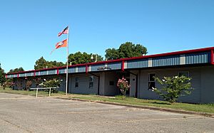
Students in Augusta attend public schools run by the Augusta School District. Students can go from early childhood programs all the way through high school. They graduate from Augusta High School.
Transportation in Augusta
Augusta is located on US Route 64 and State Highway 33. These roads help people travel to and from the city.
The Woodruff County Airport (M60) is a public airport. It is owned by the county and is about 5 miles (7 km) east of Augusta's main downtown area.
Historic Places in Augusta
Many places in and around Augusta are listed on the National Register of Historic Places. This means they are important historical sites. Some of these include:
- The Augusta Commercial Historic District
- The Augusta Electrical Generating Plant
- The Augusta Memorial Park Historic Section
- The Augusta Presbyterian Church
- The Ferguson House
- The George Washington Carver High School Home Economics Building
- The Gregory House
- The Jess Norman Post 166 American Legion Hut
- The Mathis-Hyde House
- The Woodruff County Courthouse
Other Fun Places to Visit
The Cache River National Wildlife Refuge is headquartered in Augusta. It is just south of town. This refuge protects wetlands for migrating waterfowl (like ducks). It also has some of the best-preserved bottomland hardwood forests in the Mississippi Valley.
The 64 Speedway was a popular place for car races. It closed down in 2007.
Famous People from Augusta
- Michael John Gray: A former member of the Arkansas House of Representatives. He was also the state Democratic Party chairman.
- Jimmy Gunn: A professional football player.
- John D. Price: A U.S. Navy admiral who set five world records in aviation.
- Billy Ray Smith, Sr.: A professional football player. He is the father of Billy Ray Smith, Jr..
See also
 In Spanish: Augusta (Arkansas) para niños
 | John T. Biggers |
 | Thomas Blackshear |
 | Mark Bradford |
 | Beverly Buchanan |


