
Woodruff County, Arkansas facts for kids
Quick facts for kids
Woodruff County
|
|
|---|---|

Woodruff County courthouse in Augusta
|
|

Location within the U.S. state of Arkansas
|
|
 Arkansas's location within the U.S. |
|
| Country | |
| State | |
| Founded | November 26, 1862 |
| Named for | William E. Woodruff |
| Seat | Augusta |
| Largest city | Augusta |
| Area | |
| • Total | 594 sq mi (1,540 km2) |
| • Land | 587 sq mi (1,520 km2) |
| • Water | 7.2 sq mi (19 km2) 1.2%% |
| Population
(2020)
|
|
| • Total | 6,269 |
| • Density | 10.554/sq mi (4.075/km2) |
| Time zone | UTC−6 (Central) |
| • Summer (DST) | UTC−5 (CDT) |
| Congressional district | 1st |
Woodruff County is located in the Arkansas Delta region of Arkansas. It was named after William E. Woodruff, who started Arkansas's first newspaper, the Arkansas Gazette. The county was created in 1862 and was the 54th county in Arkansas.
Woodruff County is home to one town and four cities. The main city and county seat is Augusta. The county also has many small communities that are not officially cities, and some ghost towns.
Woodruff County is one of the smallest counties in Arkansas. It covers about 587 square miles of land. In 2020, its population was 6,269 people, making it the second-smallest county in Arkansas by population.
The land in Woodruff County is mostly flat with very rich soil. Long ago, it was covered in thick forests, swamps, and bayous. Early settlers cleared much of this land for farming. The county is drained by two important rivers: the Cache River and the White River. The Cache River National Wildlife Refuge (NWR) runs through the county along the Cache River. This refuge protects forests, swamps, and homes for wildlife.
Even though there are no big Interstate highways here, two U.S. highways (US 49 and US 64) and twelve Arkansas state highways cross Woodruff County. Two Union Pacific Railroad lines also run through the county.
Contents
Understanding Woodruff County's Geography


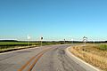
Bottom: Typical countryside in Woodruff County. This photo taken along Highway 64B north of Patterson.
Woodruff County is part of the Arkansas Delta. This area is a flat plain made from rich soil left behind by the Mississippi River over many years. The county covers about 594 square miles in total. Most of this (587 square miles) is land, and a small part (7.2 square miles) is water.
The main water features are the Cache River, which cuts through the middle of the county, and Bayou De View in the east. The White River forms the western edge of the county.
How the Land Has Changed Over Time
Before people settled here, Woodruff County was covered in dense forests, with many bayous and swamps. Settlers wanted to use the rich soil for farming, so they cleared much of the land. They grew crops like corn and cotton.
Today, most of the county (about 56 percent) is still used for farming. However, some swamp areas are protected in the Cache River NWR. Also, some old farmland has been replanted with trees.
The Cache River NWR is a very important area. It stretches for about 90 miles across several counties. It is recognized as a special wetland area worldwide. It is a key place for ducks in winter and has the largest continuous area of bottomland hardwood forest in North America. The NWR is always looking to buy more land from willing owners to expand its protected area.
Where is Woodruff County Located?
Woodruff County is about 75 miles northeast of Little Rock, the state capital. It is also about 81 miles west of Memphis, Tennessee.
It is surrounded by five other counties in the Delta region:
- Jackson County to the north
- Cross County to the northeast
- St. Francis County to the southeast
- Monroe County to the south
- Prairie County to the southwest
To the west is White County. This county is where the Delta, Ozarks, and Central Arkansas regions meet.
Woodruff County's Climate
Woodruff County has a humid subtropical climate. This means it has all four seasons. Summers can be very hot and humid, while winters are usually mild with little snow.
July is the hottest month. The average high temperature is 93°F, and the average low is 70°F. Temperatures can sometimes go above 100°F. January is the coldest month. The average high is 49°F, and the average low is 27°F. The highest temperature ever recorded was 112°F in 1936 and 1972. The lowest was -11°F on January 8, 1942.
| Climate data for Augusta Climate Data | |||||||||||||
|---|---|---|---|---|---|---|---|---|---|---|---|---|---|
| Month | Jan | Feb | Mar | Apr | May | Jun | Jul | Aug | Sep | Oct | Nov | Dec | Year |
| Record high °F (°C) | 87 (31) |
85 (29) |
90 (32) |
97 (36) |
99 (37) |
109 (43) |
112 (44) |
112 (44) |
109 (43) |
98 (37) |
87 (31) |
81 (27) |
112 (44) |
| Mean daily maximum °F (°C) | 49 (9) |
54 (12) |
63 (17) |
73 (23) |
81 (27) |
89 (32) |
93 (34) |
92 (33) |
85 (29) |
74 (23) |
62 (17) |
51 (11) |
72 (22) |
| Mean daily minimum °F (°C) | 27 (−3) |
31 (−1) |
39 (4) |
48 (9) |
58 (14) |
67 (19) |
70 (21) |
69 (21) |
60 (16) |
48 (9) |
39 (4) |
30 (−1) |
49 (9) |
| Record low °F (°C) | −11 (−24) |
−10 (−23) |
9 (−13) |
24 (−4) |
36 (2) |
44 (7) |
52 (11) |
48 (9) |
34 (1) |
24 (−4) |
11 (−12) |
−4 (−20) |
−11 (−24) |
| Average precipitation inches (mm) | 3.6 (91) |
3.8 (97) |
4.8 (120) |
5.0 (130) |
5.5 (140) |
2.9 (74) |
3.7 (94) |
2.7 (69) |
3.4 (86) |
4.7 (120) |
5.2 (130) |
5.0 (130) |
50.3 (1,281) |
| Average snowfall inches (cm) | 0.8 (2.0) |
1.0 (2.5) |
0.1 (0.25) |
0 (0) |
0 (0) |
0 (0) |
0 (0) |
0 (0) |
0 (0) |
0 (0) |
0 (0) |
0.1 (0.25) |
2.0 (5.1) |
| Source 1: The Weather Channel | |||||||||||||
| Source 2: Weather Database | |||||||||||||
Cities and Towns in Woodruff County

Woodruff County has four official cities and one official town.
- Augusta is the largest city and the county seat. It is in the western part of the county, near the White River. In 2020, Augusta had 1,998 people.
- McCrory and Patterson are next to each other in the middle of the county.
- Cotton Plant and Hunter are in the southern part of Woodruff County. In 2020, Cotton Plant had 529 people, and Hunter had 103.
Woodruff County also has many smaller communities and ghost towns. In the past, settlers often lived in small groups rather than in official towns. Some of these places, like Fitzhugh and Gregory, even had their own post offices at one time. Others are just a few houses at a crossroads that have been known by a certain name over the years.
Unincorporated Communities
These are communities that are not officially part of a city or town.
- Becton
- Dixie
- Fitzhugh
- Grays
- Gregory
- Hillemann
- Howell
- Little Dixie‡
- McClelland
- Morton
- New Augusta
- New Salem
- Pleasant Grove
- Pumpkin Bend
- Shady Grove
Historic Communities (Ghost Towns)
These are places that were once communities but are no longer populated or active.
- Barson
- Bemis
- Bulltown
- Casey
- Cavell
- Colona
- Cow Mound
- Daggett
- DeView
- Flynn
- Four Forks
- Goodrich
- Kramer
- Maberry
- McGregor
- Morelock
- Negro Head Corner
- Overcup
- Penrose
- Quinlan
- Revel
- Riverside
- Simmons
- Sturdevant
- Taylorville
- Tip
- Union
- Wiville
Townships in Woodruff County
A township is a small area of land, often used for local government or land division.
- Augusta (Augusta)
- Barnes
- Cache
- Caney (Hunter)
- Cotton Plant (Cotton Plant)
- Dent
- De View (McCrory, Patterson)
- Franks
- Freeman
- Garden
- Point
- Pumpkin Bend
- White River
Woodruff County's Population Over Time
| Historical population | |||
|---|---|---|---|
| Census | Pop. | %± | |
| 1870 | 6,891 | — | |
| 1880 | 8,646 | 25.5% | |
| 1890 | 14,009 | 62.0% | |
| 1900 | 16,304 | 16.4% | |
| 1910 | 20,049 | 23.0% | |
| 1920 | 21,547 | 7.5% | |
| 1930 | 22,682 | 5.3% | |
| 1940 | 22,133 | −2.4% | |
| 1950 | 18,957 | −14.3% | |
| 1960 | 13,954 | −26.4% | |
| 1970 | 11,566 | −17.1% | |
| 1980 | 11,222 | −3.0% | |
| 1990 | 9,520 | −15.2% | |
| 2000 | 8,741 | −8.2% | |
| 2010 | 7,260 | −16.9% | |
| 2020 | 6,269 | −13.7% | |
| 2023 (est.) | 5,964 | −17.9% | |
| U.S. Decennial Census 1790–1960 1900–1990 1990–2000 2010 |
|||

The population of Woodruff County has changed over the years. In 2020, there were 6,269 people living in the county. These people lived in 2,932 households, and 1,855 of these were families.
Population by Race in 2020
| Race | Number of People | Percentage |
|---|---|---|
| White | 4,235 | 67.55% |
| Black or African American | 1,601 | 25.54% |
| Native American | 8 | 0.13% |
| Asian | 22 | 0.35% |
| Other/Mixed | 307 | 4.9% |
| Hispanic or Latino | 96 | 1.53% |
Important Infrastructure in Woodruff County
Infrastructure refers to the basic facilities and systems that a country or area needs to function.
Aviation (Airports)
The Woodruff County Airport is the only public airport in the county. It is located between Patterson and Augusta. This airport is mainly used for small planes, often for farming activities like crop spraying, and for fun flying. In the year ending June 30, 2014, there were 5,500 flights at this airport.
Major Roads and Highways

These are the main roads that help people travel through Woodruff County.
 U.S. Highway 49
 U.S. Highway 64
 Highway 17
 Highway 33
 Highway 37
 Highway 38
 Highway 78
 Highway 145
 Highway 260
 Highway 262
 Highway 269
 Highway 284
 Highway 306
 Highway 339
Utilities (Water Systems)

The Arkansas Department of Health makes sure that public water systems across the state are safe. Woodruff County has seven main water systems for its communities:
- Augusta Waterworks
- Breckenridge Union Water Association (UWA)
- Cross County Rural Water System
- Cotton Plant Waterworks
- McCrory Waterworks
- Patterson Waterworks
- West Woodruff Water District
Augusta Waterworks serves the most people, about 2,284. McCrory serves 1,647 people, and Breckenridge UWA serves 1,267. All these water systems get their water from underground sources, except for West Woodruff Water District, which buys its water from Patterson.
Images for kids
-
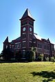
Woodruff County courthouse in Augusta
-
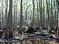
The Cache River runs through a hardwood forest in Woodruff County
-
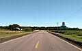
Typical countryside in Woodruff County. This photo taken along Highway 64B north of Patterson.
-
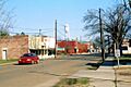
Streetside in Cotton Plant
-
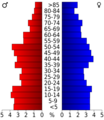
Age pyramid Woodruff County
-
Highway 64B east of Augusta
-
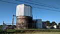
The Patterson Water Treatment Facility produces potable water distributed by Patterson Waterworks and the West Woodruff Water District.
See also
 In Spanish: Condado de Woodruff (Arkansas) para niños
