McCrory, Arkansas facts for kids
Quick facts for kids
McCrory, Arkansas
|
|
|---|---|
 |
|
| Motto(s):
The Heart of Woodruff County
|
|

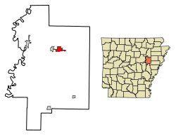
Location of McCrory in Woodruff County, Arkansas.
|
|
| Country | United States |
| State | Arkansas |
| County | Woodruff |
| Area | |
| • Total | 2.37 sq mi (6.13 km2) |
| • Land | 2.37 sq mi (6.13 km2) |
| • Water | 0.00 sq mi (0.00 km2) |
| Elevation | 207 ft (63 m) |
| Population
(2020)
|
|
| • Total | 1,583 |
| • Density | 668.50/sq mi (258.11/km2) |
| Time zone | UTC-6 (Central (CST)) |
| • Summer (DST) | UTC-5 (CDT) |
| ZIP code |
72101
|
| Area code(s) | 870 |
| FIPS code | 05-42500 |
| GNIS feature ID | 2405046 |
McCrory is a city located in Woodruff County, Arkansas, in the United States. In 2020, about 1,583 people lived there.
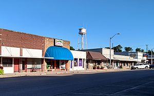
McCrory is home to several important historical sites. These include the McCrory Commercial Historic District, the McCrory Waterworks, and the Dr. John William Morris Clinic. All of these places are listed on the National Register of Historic Places listings in Woodruff County, Arkansas. This means they are recognized for their special history and architecture.
Contents
History of McCrory
The city of McCrory started to form around 1886. This happened when a local person named Wade McCrory gave land to the St. Louis, Iron Mountain and Southern Railway. This railway planned to build a track from Memphis, Tennessee to Little Rock.
The first train arrived in McCrory in 1887. The town was officially made a city on January 30, 1890. Later, in 1906, local business people tried to connect McCrory to another railway. They built a small railway line, called a tramway, to reach the Batesville and Brinkley Railroad. This connection point eventually became the town of Patterson.
In 1910, the owners of this tramway decided to create a bigger railroad. They called it the McCrory and Beedeville Southern Railway. The plan was to connect McCrory to the town of Beedeville. However, the railroad faced money problems and stopped operating by 1914. The tracks were removed soon after.
Geography of McCrory
McCrory is located entirely on land. According to the United States Census Bureau, the city covers an area of about 2.4 square miles (6.13 square kilometers).
Population Changes
| Historical population | |||
|---|---|---|---|
| Census | Pop. | %± | |
| 1890 | 299 | — | |
| 1900 | 225 | −24.7% | |
| 1910 | 637 | 183.1% | |
| 1920 | 687 | 7.8% | |
| 1930 | 924 | 34.5% | |
| 1940 | 1,010 | 9.3% | |
| 1950 | 1,115 | 10.4% | |
| 1960 | 1,053 | −5.6% | |
| 1970 | 1,378 | 30.9% | |
| 1980 | 1,942 | 40.9% | |
| 1990 | 1,971 | 1.5% | |
| 2000 | 1,850 | −6.1% | |
| 2010 | 1,729 | −6.5% | |
| 2020 | 1,583 | −8.4% | |
| U.S. Decennial Census | |||
McCrory's Population in 2020
The 2020 United States Census counted 1,583 people living in McCrory. There were 741 households and 500 families in the city at that time.
| Race | Num. | Perc. |
|---|---|---|
| White | 1,244 | 78.58% |
| Black or African American | 227 | 14.34% |
| Asian | 8 | 0.51% |
| Other/Mixed | 88 | 5.56% |
| Hispanic or Latino | 16 | 1.01% |
Education in McCrory
Students in McCrory attend public schools run by the McCrory School District. The district includes McCrory High School, where older students go to learn.
See also
 In Spanish: McCrory (Arkansas) para niños
 | Janet Taylor Pickett |
 | Synthia Saint James |
 | Howardena Pindell |
 | Faith Ringgold |

