Fordland, Missouri facts for kids
Quick facts for kids
Fordland, Missouri
|
|
|---|---|

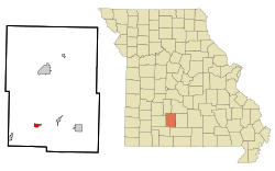
Location of Fordland, Missouri
|
|
| Country | United States |
| State | Missouri |
| County | Webster |
| Government | |
| • Type | N/A |
| Area | |
| • Total | 1.11 sq mi (2.87 km2) |
| • Land | 1.11 sq mi (2.86 km2) |
| • Water | 0.00 sq mi (0.00 km2) |
| Elevation | 1,604 ft (489 m) |
| Population
(2020)
|
|
| • Total | 778 |
| • Density | 703.44/sq mi (271.71/km2) |
| Time zone | UTC-6 (Central (CST)) |
| • Summer (DST) | UTC-5 (CDT) |
| ZIP code |
65652
|
| Area code(s) | 417 |
| FIPS code | 29-25012 |
| Website | http://cityoffordland.com/ |
Fordland is a small city in Webster County, Missouri, in the United States. It is located in the southern part of the county. In 2020, about 778 people lived there. Fordland is part of the larger Springfield Metropolitan Area.
Contents
History of Fordland
Fordland was officially planned and marked out in 1882. Its post office started operating in the same year. The community got its name from J. S. Ford. He was a "comptroller" (a person who manages money) for the Kansas City, Fort Scott and Memphis Railroad.
Geography and Location
Fordland is located on the southeastern edge of the Springfield Plateau. This area is part of the Ozarks region in south central Missouri. The city is found along U.S. Route 60. It is about four miles east of Diggins and 6.5 miles southwest of Rogersville.
According to the United States Census Bureau, Fordland covers a total area of about 1.11 square miles (2.87 square kilometers). All of this area is land.
Because Fordland is at a higher elevation than Springfield, many TV and FM radio station towers are located here. These towers help broadcast signals to the surrounding area.
Population and People
| Historical population | |||
|---|---|---|---|
| Census | Pop. | %± | |
| 1920 | 248 | — | |
| 1930 | 327 | 31.9% | |
| 1940 | 331 | 1.2% | |
| 1950 | 302 | −8.8% | |
| 1960 | 338 | 11.9% | |
| 1970 | 399 | 18.0% | |
| 1980 | 569 | 42.6% | |
| 1990 | 523 | −8.1% | |
| 2000 | 684 | 30.8% | |
| 2010 | 800 | 17.0% | |
| 2020 | 778 | −2.7% | |
| U.S. Decennial Census | |||
Fordland's Population in 2010
Based on the census from 2010, there were 800 people living in Fordland. These people made up 312 households and 205 families. The city had about 720 people per square mile.
Most of the people in Fordland were White (96.3%). A small number were African American, Native American, or Asian. About 3.1% of the population identified as Hispanic or Latino.
About 37.2% of households had children under 18 living with them. Many households (43.3%) were married couples. The average household had 2.56 people, and the average family had 3.20 people.
The average age of people in Fordland was 34.2 years. About 28.6% of residents were under 18 years old. About 13% were 65 years or older. There were slightly more females (52.5%) than males (47.5%) in the city.
Education in Fordland
The Fordland R-III School District serves the students in the area. This district operates one elementary school and one middle school. It also runs Fordland High School, where older students attend.
See also
 In Spanish: Fordland (Misuri) para niños
 | Victor J. Glover |
 | Yvonne Cagle |
 | Jeanette Epps |
 | Bernard A. Harris Jr. |

