
Lake of the Ozarks facts for kids
Quick facts for kids Lake of the Ozarks |
|
|---|---|

Aerial panorama of Lake of the Ozarks
|
|

Lake of the Ozarks
Location in Missouri

Lake of the Ozarks
Location in the United States
|
|
| Location | Benton, Camden, Miller, and Morgan Counties in Missouri |
| Coordinates | 38°12′09″N 92°37′35″W / 38.20250°N 92.62639°W |
| Type | Reservoir |
| Primary inflows | Grandglaize Creek, Gravois Creek, Niangua River, Osage River |
| Primary outflows | Osage River |
| Catchment area | 14,000 sq mi (36,300 km2) |
| Basin countries | United States |
| Managing agency | Ameren Missouri |
| Built | August 6, 1929 |
| First flooded | February 2, 1931 |
| Max. length | 93 miles (150 km) |
| Surface area | 54,000 acres (220 km2) |
| Max. depth | 130 ft (40 m) |
| Water volume | 1,927,000 acre⋅ft (2.377×10⁹ m3) |
| Residence time | 2-4 months |
| Shore length1 | 1,150 miles (1,850 km) |
| Surface elevation | 659 ft (201 m) |
| Settlements | Camdenton, Lake Ozark, Laurie, Osage Beach, Sunrise Beach, Village of Four Seasons |
| 1 Shore length is not a well-defined measure. | |
The Lake of the Ozarks is a large reservoir (a man-made lake) in central Missouri. It was created by building a dam across the Osage River. This huge lake also includes parts of three smaller rivers and creeks: the Niangua River, Grandglaize Creek, and Gravois Creek.
The lake covers about 54,000 acres (220 km2) of water and has an amazing 1,150 miles (1,850 km) of shoreline. That's more shoreline than the entire coast of California! The main part of the lake, called the Osage Arm, stretches for 92 miles (148 km). Because of its long, winding shape, the lake is sometimes called "Puff The Magic Dragon." This fun nickname has even inspired names for local events and places.
Contents
Building the Lake

The idea for a power plant on the Osage River started way back in 1912. A developer named Ralph Street began planning and building roads for a dam. However, he ran out of money in the mid-1920s and stopped the project.
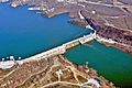
Later, the Union Electric Company from St. Louis, Missouri took over. They built the 2,543-foot (775 m) long Bagnell Dam. Construction began on August 8, 1929, and the dam was finished in April 1931. The lake officially filled up on May 20, 1931.
During its construction, people called it Osage Reservoir or Lake Osage. The state government even tried to name it Lake Benton. But everyone just kept calling it "Lake of the Ozarks" because of where it was located. The power plant at the dam is still known as the "Osage Hydroelectric Plant."
When it was built, the Lake of the Ozarks was the largest man-made lake in the United States. It was also one of the biggest in the world! Its main purpose was to create electricity for homes and businesses.
A Popular Destination
The Lake of the Ozarks quickly became a very popular place for tourists. Unlike many lakes built for flood control, most of the land around this lake is privately owned. This means people can build homes very close to the water.
Today, there are over 70,000 homes along the lake, and many of them are vacation homes. The lake is now a major resort area. More than 5 million people visit it every year to enjoy the water and scenery.
Sometimes, there are rules about building near the lake. In 2011, the Federal Energy Regulatory Commission (FERC) renewed the permit for the power plant. They found that some homes were built too close to the lake's boundary. This led to discussions between the utility company, homeowners, and government officials. In 2015, FERC allowed the utility company to work on permits for some of these structures.
Where is the Lake?
The Lake of the Ozarks is located in the beautiful Ozark Mountains in central Missouri. The Bagnell Dam is at an elevation of 659 feet (201 m). The lake stretches across four Missouri counties: Benton, Camden, Morgan, and Miller counties.
The lake is very long and winding. It has a main channel from the Osage River, which is about 93-mile-long (150 km). It also has several "arms" that are fed by different rivers and creeks. For example, the southwestern arm gets water from the Niangua and Little Niangua rivers. All these arms and smaller streams create many coves and inlets, which is why the lake has so much shoreline.
Several towns and communities are located near the Lake of the Ozarks. The biggest city is Osage Beach, which has a population of 4,570. Other communities include Camdenton, Lake Ozark, Sunrise Beach, and Laurie.
Lake Facts
The Lake of the Ozarks can hold about 1,927,000 acre-feet (2.377×10⁹ m3) of water. When it's full, its surface is about 660 feet (200 m) high and covers 54,000 acres (220 km2). The water level usually stays very steady, changing by only about 5 feet (1.5 m). Since it was built mainly for power, it doesn't have a lot of space for flood control.
The Lake of the Ozarks is one of the largest reservoirs in Missouri. Some sources say it's the biggest, while others say it's the second largest after Truman Reservoir.
Managing the Lake

The Bagnell Dam is managed by Ameren Missouri. They are in charge of operating the dam and making sure the lake's water levels are correct. They also manage the land around the lake that is part of the project area. If anyone wants to build something like a dock or a seawall, they need permission from Ameren Missouri first.
Fun at the Lake
The Lake of the Ozarks is a fantastic place for outdoor activities and tourism.
- Lake of the Ozarks State Park: A huge area of 17,500 acres (71 km2) was set aside for a national park when the lake was built. In 1946, this land became Lake of the Ozarks State Park, which is the largest state park in Missouri.
- Ha Ha Tonka State Park: Another beautiful state park, Ha Ha Tonka State Park, is located on the Niangua Arm of the lake. It's known for its castle ruins and natural bridges.
One famous spot at the Lake of the Ozarks State Park is Party Cove. It's a popular gathering spot for boats, especially on holidays like Fourth of July. Hundreds of boats gather there, and it's a lively place.
In 2020, the Lake of the Ozarks received attention when many people gathered there on Memorial Day.
Events at the Lake
- AquaPolooza: This event happens every July. People gather on rafts and inflatable tubes, linking their boats together. Live music is often played for hours.
- "The Shootout": At the end of every summer, the lake hosts "The Shootout." This is the biggest powerboat racing event of the year. Boats race over a three-mile course, showing off their speed.
The Lake in Media
The TV series Ozark is set in Osage Beach, Missouri, which is a real city on the lake. The show has helped make the Lake of the Ozarks more famous and increased tourism. In 2018, a restaurant called "Marty Byrde's" even opened in Lake Ozark, Missouri, inspired by the TV series. It has menu items named after characters from the show!
Images for kids
-
Bagnell Dam

