
Little Osage River facts for kids
Quick facts for kids Little Osage River |
|
|---|---|

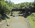
The Little Osage River near Horton, Missouri
|
|

Map of the Osage River watershed showing the Little Osage River
|
|
| Country | United States |
| State | Kansas, Missouri |
| Physical characteristics | |
| River mouth | Osage River Vernon County, Missouri 722 ft (220 m) 38°01′39″N 94°14′39″W / 38.02750°N 94.24417°W |
| Length | 88 mi (142 km) |
| Basin features | |
| Tributaries |
|
| Watersheds | Little Osage-Osage-Missouri-Mississippi |
The Little Osage River is a river in the central United States. It flows for about 88 miles (142 km) through eastern Kansas and western Missouri. This river is a tributary of the Osage River. This means it's a smaller river that flows into a larger one. The Little Osage River is part of a huge watershed. A watershed is an area of land where all the water drains into a common outlet. This watershed eventually leads to the Mississippi River. The river got its name from the Osage Nation, a Native American tribe.
River's Journey
The Little Osage River begins in northeastern Allen County, Kansas. It starts where two smaller streams, the North Fork and Middle Fork, join together. This joining point is called a confluence.
From there, the river flows southeast into Bourbon County. Another stream, the South Fork, also joins the river here. The river then turns and flows towards the east.
The Little Osage River makes a sharp turn south. It crosses under Kansas 65 near Xenia. The river then winds its way eastward. It passes just north of Fulton and goes under U.S. Route 69.
The river then enters southwestern Vernon County, Missouri. In Vernon County, it flows north of Stotesbury. It continues on to pass under U.S. Route 71 north of Horton.
The Little Osage River flows through the Four Rivers Conservation Area. Here, it is joined by the Marmaton River.
Where It Ends
The Little Osage River reaches its end on the border of Vernon and Bates counties. Here, it joins with the Marais des Cygnes River. When these two rivers meet, they form the larger Osage River. This meeting point is about 6 miles (10 km) west of Schell City.
The area east of where the Marmaton River joins is now part of the Harry S Truman Reservoir. This means that part of the river's original path is now covered by the reservoir's waters.
Images for kids
-
The Little Osage River flowing through the landscape.
