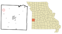
Stotesbury, Missouri facts for kids
Quick facts for kids
Stotesbury, Missouri
|
|
|---|---|

Location of Stotesbury, Missouri
|
|
| Country | United States |
| State | Missouri |
| County | Vernon |
| Area | |
| • Total | 0.11 sq mi (0.29 km2) |
| • Land | 0.11 sq mi (0.29 km2) |
| • Water | 0.00 sq mi (0.00 km2) |
| Elevation | 791 ft (241 m) |
| Population
(2020)
|
|
| • Total | 12 |
| • Density | 109.09/sq mi (42.04/km2) |
| Time zone | UTC-6 (Central (CST)) |
| • Summer (DST) | UTC-5 (CDT) |
| FIPS code | 29-70954 |
| GNIS feature ID | 2397684 |
Stotesbury is a small village located in the northwest part of Vernon County, Missouri, in the United States. In 2010, the village had 18 people living there. By 2020, the population was 12.
Contents
History of Stotesbury
Stotesbury was officially planned and marked out on a map in 1893. This happened when the railroad tracks were built to reach that area. The village was named after E. T. Stotesbury, who worked for the railroad.
A post office opened in Stotesbury in 1893. It helped people send and receive mail for many years until it closed in 1985.
Besides the post office, Stotesbury also had a two-story school building. By 1990, most of the school was taken down, and only its foundation and basement were left. At one time, there was also a working blacksmith shop near the railroad tracks and the coal yard.
Geography of Stotesbury
Stotesbury is found where two Missouri roads, Route D and Route V, meet. The border between Missouri and Kansas is only about 2.5 miles (4 km) to the west. The Little Osage River flows about half a mile (0.8 km) north of the village.
Other nearby communities include Richards, which is four miles (6.4 km) south. The city of Nevada is about fourteen miles (22.5 km) to the southeast.
The United States Census Bureau says that Stotesbury covers a total area of 0.11 square miles (0.29 square kilometers). All of this area is land, with no water.
Population of Stotesbury
| Historical population | |||
|---|---|---|---|
| Census | Pop. | %± | |
| 1900 | 154 | — | |
| 1910 | 159 | 3.2% | |
| 1920 | 141 | −11.3% | |
| 1930 | 113 | −19.9% | |
| 1940 | 102 | −9.7% | |
| 1950 | 71 | −30.4% | |
| 1960 | 64 | −9.9% | |
| 1970 | 35 | −45.3% | |
| 1980 | 48 | 37.1% | |
| 1990 | 42 | −12.5% | |
| 2000 | 43 | 2.4% | |
| 2010 | 18 | −58.1% | |
| 2020 | 12 | −33.3% | |
| U.S. Decennial Census | |||
2010 Census Information
According to the census from 2010, 18 people lived in Stotesbury. These people lived in 7 different homes, and 6 of those were families.
All the people living in the village were identified as White. The average age of people in the village was 54 years old. About 5.6% of the residents were under 18 years old. Most people were between 45 and 64 years old, or 65 years and older.
See also
 In Spanish: Stotesbury (Misuri) para niños
 | Selma Burke |
 | Pauline Powell Burns |
 | Frederick J. Brown |
 | Robert Blackburn |

