
Allen County, Kansas facts for kids
Quick facts for kids
Allen County
|
|
|---|---|

Old Allen County Jail in Iola (2008)
|
|

Location within the U.S. state of Kansas
|
|
 Kansas's location within the U.S. |
|
| Country | |
| State | |
| Founded | August 25, 1855 |
| Named for | William Allen |
| Seat | Iola |
| Largest city | Iola |
| Area | |
| • Total | 505 sq mi (1,310 km2) |
| • Land | 500 sq mi (1,000 km2) |
| • Water | 5.0 sq mi (13 km2) 1.0%% |
| Population
(2020)
|
|
| • Total | 12,526 |
| • Density | 25.1/sq mi (9.7/km2) |
| Time zone | UTC−6 (Central) |
| • Summer (DST) | UTC−5 (CDT) |
| Area code | 620 |
| Congressional district | 2nd |
Allen County is a county located in the southeastern part of Kansas, a state in the United States. Its main city and county seat (where the county government is) is Iola. In 2020, about 12,526 people lived here. The county was named after William Allen, who was a U.S. Senator from Ohio. He strongly supported the idea of people moving west across America.
Contents
History of Allen County
How did Allen County begin?
For thousands of years, the Great Plains of North America were home to nomadic Native American tribes.
In the 16th to 18th centuries, France claimed large parts of North America. After a war in 1762, France secretly gave this land to Spain. But in 1802, Spain gave most of it back to France.
In 1803, the United States bought a huge area of land, including what is now Kansas, from France. This was called the Louisiana Purchase. It was a very big deal!
When was Allen County formed?
In 1854, the Kansas Territory was created. Allen County was one of the first 33 counties set up by the new government in August 1855. This was six years before Kansas became a state in 1861.
The county was named after William Allen, a U.S. Senator from Ohio. The first leaders of the county were chosen temporarily until an election in 1857.
Who were the first settlers?
Richard J. Fuqua and his family are thought to be the first white settlers in Allen County. They arrived in January 1855 near the Neosho River. Fuqua set up a trading post that was popular with the Sac and Fox Native American tribes.
More settlers arrived in 1855, especially near the Neosho River. Many early settlers supported slavery, but few enslaved people were actually brought to the county. People who were against slavery were very vocal, and any enslaved people in the county were either freed or taken elsewhere.
What about the first towns?
The first town and county seat was Cofachique. It was started in 1855 by settlers who supported slavery. For almost two years, it was the only town in Allen County. However, it started to decline after 1857 when other towns were built. Cofachique had problems with getting good water and was hard to reach. Also, tensions between settlers who supported and opposed slavery might have played a role.
By 1859, Cofachique had almost disappeared. The county seat moved to Humboldt for a while in 1857. But in 1865, Iola became the county seat and has been ever since.
Allen County's first jail was built in Iola in 1869. It cost $8,400. This jail was used until a new one opened in 1959. Today, the old jail is a museum.
What was life like in the early days?
The year 1860 was very tough for the county. A long period of dry weather, or drought, made farming very difficult. Many people who had recently moved to the county decided to leave and go back east because they were worried about not having enough food.
How did the county grow?
Even during the American Civil War, the county slowly grew. The population steadily increased from 3,082 people in 1860 to 7,022 in 1870.
The biggest growth happened between 1890 and 1910. In 1910, Allen County had its highest population ever, with 27,640 residents. This growth was probably because oil and natural gas were discovered and produced near Iola. After that, the population slowly decreased. By 2010, it was similar to what it was in 1890.
Geography of Allen County

Allen County covers about 505 square miles. Most of this (500 square miles) is land, and about 5 square miles (1.0%) is water. The county is in the southeastern part of Kansas. It's about 21 miles from north to south and 24 miles from east to west.
What is the land like?
The land in Allen County is generally gently rolling, meaning it has small hills, but it's flatter than many other parts of eastern Kansas. The soil is rich and good for farming. The flat lands along the rivers are about one and a half miles wide. The rest of the land is gently rolling or flat prairie.
Common trees in the county include black walnut, hickory, cottonwood, oak, hackberry, and elm.
What are the main rivers?
The main river is the Neosho River. It flows through the western part of the county from north to south. Smaller creeks like Indian, Martin's, Deer, Elm, and Vegetarian Creek flow into it.
The Marmaton River starts in the eastern part of the county and flows through the southeastern area. The Little Osage River also starts nearby and flows northeast.
Which counties are next to Allen County?
Allen County shares borders with these counties:
- Anderson County (north)
- Linn County (northeast)
- Bourbon County (east)
- Neosho County (south)
- Wilson County (southwest)
- Woodson County (west)
- Coffey County (northwest)
People in Allen County

| Historical population | |||
|---|---|---|---|
| Census | Pop. | %± | |
| 1860 | 3,082 | — | |
| 1870 | 7,022 | 127.8% | |
| 1880 | 11,303 | 61.0% | |
| 1890 | 13,509 | 19.5% | |
| 1900 | 19,507 | 44.4% | |
| 1910 | 27,640 | 41.7% | |
| 1920 | 23,509 | −14.9% | |
| 1930 | 21,391 | −9.0% | |
| 1940 | 19,874 | −7.1% | |
| 1950 | 18,187 | −8.5% | |
| 1960 | 16,369 | −10.0% | |
| 1970 | 15,043 | −8.1% | |
| 1980 | 15,654 | 4.1% | |
| 1990 | 14,638 | −6.5% | |
| 2000 | 14,385 | −1.7% | |
| 2010 | 13,371 | −7.0% | |
| 2020 | 12,526 | −6.3% | |
| 2023 (est.) | 12,412 | −7.2% | |
| U.S. Decennial Census 1790-1960 1900-1990 1990-2000 2010-2020 |
|||
What do the numbers tell us?
In 2010, there were 13,371 people living in Allen County. Most residents (93.3%) were White. Other groups included Black or African American (1.9%), Native American (0.8%), and Asian (0.5%). About 2.9% of the population was Hispanic or Latino.
In 2000, there were 14,385 people. The county had 5,775 households, and 3,892 families. The average household had 2.43 people, and the average family had 2.98 people.
The population was spread out by age:
- 25.2% were under 18 years old.
- 9.8% were 18 to 24 years old.
- 24.1% were 25 to 44 years old.
- 22.9% were 45 to 64 years old.
- 18.0% were 65 years or older.
The median age (the middle age of all people) was 39 years.
Education in Allen County
School Districts
Allen County has several unified school districts:
- Marmaton Valley USD 256
- Iola USD 257
- Humboldt USD 258
Colleges
- Allen County Community College is located here, offering higher education.
Transportation in Allen County
Major Roads
- U.S. Route 54 goes east-west through cities like Moran, La Harpe, Gas, and Iola.
- U.S. Route 59 is a north-south road that passes through Mildred and Moran.
- U.S. Route 169 also goes north-south, bypassing cities like Iola, Bassett, and Humboldt. Part of this road between Iola and Chanute is a freeway. US-169 is a direct route between Kansas City and Tulsa.
Bus Services
- Jefferson Lines provides bus transportation.
Airports
Allen County has several airports:
- Allen County Airport (K88) is a public airport.
- Croisant Airport (7KS5) is private.
- Ensminger Airport (74KS) is private.
- National Airport is public.
- Womack Airport is public.
Communities in Allen County
Allen County has several cities, smaller communities, and even some "ghost towns" (places where people used to live but don't anymore).
Cities
Unincorporated communities
These are smaller communities that are not officially cities. ‡ means part of the community is in another county. † means it's a Census-Designated Place (CDP), a special area defined for census data.
Ghost towns
These towns no longer exist or have very few people left.
- Cofachique
- Octagon City
Images for kids
-
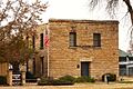
Old Allen County Jail in Iola (2008)
-
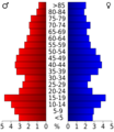
Population pyramid based on 2000 census age data
-
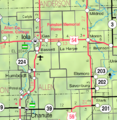
2005 map of Allen County (map legend)
See also
 In Spanish: Condado de Allen (Kansas) para niños
