Neosho County, Kansas facts for kids
Quick facts for kids
Neosho County
|
|
|---|---|

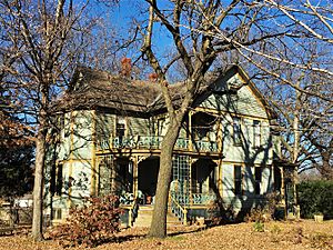
James and Ella Truitt House in Chanute (2017)
|
|

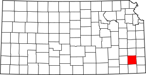
Location within the U.S. state of Kansas
|
|
 Kansas's location within the U.S. |
|
| Country | |
| State | |
| Founded | June 3, 1861 |
| Named for | Neosho River |
| Seat | Erie |
| Largest city | Chanute |
| Area | |
| • Total | 578 sq mi (1,500 km2) |
| • Land | 571 sq mi (1,480 km2) |
| • Water | 6.3 sq mi (16 km2) 1.1%% |
| Population
(2020)
|
|
| • Total | 15,904 |
| • Density | 27.9/sq mi (10.8/km2) |
| Time zone | UTC−6 (Central) |
| • Summer (DST) | UTC−5 (CDT) |
| Congressional district | 2nd |
Neosho County is a county in Southeast Kansas. Its main town, called the county seat, is Erie. In 2020, about 15,904 people lived here. The county got its name from the Neosho River, which flows through the area.
Contents
History of Neosho County
Early Times
For thousands of years, the Great Plains of North America were home to nomadic Native American tribes. They moved around to hunt and gather food.
From the 1500s to the 1700s, France said it owned large parts of North America. But in 1762, after a big war called the French and Indian War, France secretly gave its land, known as New France, to Spain. This was part of a deal called the Treaty of Fontainebleau.
The 1800s
In 1802, Spain gave most of this land back to France. Then, in 1803, the United States bought a huge area from France. This was the famous Louisiana Purchase. It included most of what is now Kansas. The U.S. paid a very small amount for it: about 2.83 cents for every acre.
In 1854, the Kansas Territory was set up. Then, in 1861, Kansas became the 34th U.S. state. In that same year, Neosho County was officially created.
The first railroad tracks were built through Neosho County in 1870. This helped people and goods move around much faster.
Geography of Neosho County
Neosho County covers a total area of about 578 square miles (1,497 square kilometers). Most of this is land, about 571 square miles (1,479 square kilometers). The rest, about 6.3 square miles (16 square kilometers), is water.
Neighboring Counties
Neosho County shares its borders with several other counties:
- Allen County (to the north)
- Bourbon County (to the northeast)
- Crawford County (to the east)
- Labette County (to the south)
- Montgomery County (to the southwest)
- Wilson County (to the west)
- Woodson County (to the northwest)
People of Neosho County

The number of people living in Neosho County has changed over the years. Here's how the population has grown and shrunk:
| Historical population | |||
|---|---|---|---|
| Census | Pop. | %± | |
| 1860 | 88 | — | |
| 1870 | 10,206 | 11,497.7% | |
| 1880 | 15,121 | 48.2% | |
| 1890 | 18,561 | 22.7% | |
| 1900 | 19,254 | 3.7% | |
| 1910 | 23,754 | 23.4% | |
| 1920 | 24,000 | 1.0% | |
| 1930 | 22,665 | −5.6% | |
| 1940 | 22,210 | −2.0% | |
| 1950 | 20,348 | −8.4% | |
| 1960 | 19,455 | −4.4% | |
| 1970 | 18,812 | −3.3% | |
| 1980 | 18,967 | 0.8% | |
| 1990 | 17,035 | −10.2% | |
| 2000 | 16,997 | −0.2% | |
| 2010 | 16,512 | −2.9% | |
| 2020 | 15,904 | −3.7% | |
| 2023 (est.) | 15,420 | −6.6% | |
| U.S. Decennial Census 1790-1960 1900-1990 1990-2000 2010-2020 |
|||
In 2000, there were about 16,997 people living in the county. The average number of people per square mile was about 30.
Education in Neosho County
Schools in Neosho County are organized into "Unified School Districts" (USDs). These districts manage public schools from kindergarten through high school.
School Districts
- Erie-Galesburg USD 101: This district serves students in Erie, Galesburg, and Stark.
- Southeast USD 247: This district mainly covers parts of Crawford and Cherokee counties, but also includes small areas of Labette and Neosho counties.
- Chanute USD 413: This district serves the city of Chanute.
- Chetopa–St. Paul USD 505: This district covers the areas around Chetopa and St. Paul.
- Cherryvale-Thayer USD 447: This district serves the communities of Cherryvale and Thayer.
Communities in Neosho County
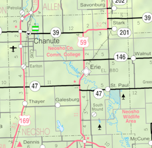
Neosho County has several cities and smaller communities.
Cities
- Chanute
- Earlton
- Erie (This is the county seat, where the county government is located)
- Galesburg
- St. Paul
- Stark
- Thayer
Unincorporated Communities
These are smaller communities that are not officially organized as cities.
- Kimball
- Leanna‡ (Part of this community might be in a neighboring county)
- Morehead
- Odense
- Shaw
- South Mound† (This is a "Census-Designated Place," meaning the Census Bureau tracks its population)
- Urbana† (This is also a Census-Designated Place)
Ghost Towns
- Ladore (A ghost town is a town that used to exist but is now empty or abandoned.)
See also
 In Spanish: Condado de Neosho para niños
 | Jessica Watkins |
 | Robert Henry Lawrence Jr. |
 | Mae Jemison |
 | Sian Proctor |
 | Guion Bluford |


