St. Paul, Kansas facts for kids
Quick facts for kids
St. Paul, Kansas
|
|
|---|---|

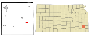
Location within Neosho County and Kansas
|
|

|
|
| Country | United States |
| State | Kansas |
| County | Neosho |
| Founded | Osage Mission (1857) St. Paul (1895) |
| Incorporated | 1869 |
| Area | |
| • Total | 1.17 sq mi (3.02 km2) |
| • Land | 1.17 sq mi (3.02 km2) |
| • Water | 0.00 sq mi (0.00 km2) |
| Elevation | 896 ft (273 m) |
| Population
(2020)
|
|
| • Total | 614 |
| • Density | 524.8/sq mi (203.3/km2) |
| Time zone | UTC-6 (CST) |
| • Summer (DST) | UTC-5 (CDT) |
| ZIP code |
66771
|
| Area code | 620 |
| FIPS code | 20-62500 |
| GNIS ID | 2396514 |
St. Paul or Saint Paul is a city in Neosho County, Kansas, United States. As of the 2020 census, the population of the city was 614 people.
Contents
History of St. Paul
St. Paul has a rich history, starting as a mission and growing into a city. It was first known as Osage Mission.
Founding of Osage Mission
Father John Schoenmakers, S.J. started Osage Mission on April 28, 1847. He was known as the "Apostle to the Osage" because he helped the Osage people a lot. He also helped new settlers who moved to the area.
Father Schoenmakers worked as a spiritual leader, doctor, and teacher for 36 years. He even served as the U.S. postmaster for Osage Mission. He built the stone structure of the current St. Francis Church. You can find his burial site in St. Francis Cemetery, just east of the church.
Important People in Early History
John Allan Mathews was another important person in Osage Mission. He was married to Mary Williams and later to her sister Sarah Williams. The Williams sisters were daughters of William S. Williams and his Osage wife, A-Ci'n-Ga.
Mathews worked as a blacksmith for the Seneca and Osage tribes. He had different ideas from Father Schoenmakers about how society should be. This led to disagreements between them.
Osage Mission During the Civil War
During the Civil War, both Union and Confederate soldiers were interested in Osage Mission. Union troops were stationed there from about 1862 to 1865. Confederate supporters also visited or were near the mission at times.
How Osage Mission Became St. Paul
By 1883, people wanted to change the name of Osage Mission. They felt the name suggested it was still only an Indian mission. Some suggested "Neona" to honor a chief's daughter.
However, many locals preferred the name St. Paul. In an election on April 11, 1895, the citizens voted for St. Paul. The name was likely chosen to honor St. Paul of the Cross, who had recently started a religious community there. The post office officially changed its name to Saint Paul in May 1895.
Historic Buildings and Sites
The historic St. Francis Hieronymo Church was built in 1884. It was repaired in 2007 after a storm in 2005 damaged its steeple.
The Osage Mission-Neosho County Museum is located right next to the church. On the museum grounds, you can also see the Lone Elm School. This was a one-room schoolhouse that operated from 1867 to 1951.
The St. Francis Parish Cemetery shows a lot of the area's history. Another historic building is the Osage Mission Infirmary & Guest House. This was once a girls' school started by Mother Bridget Hayden in 1847. It is now called St. Ann's Bed and Breakfast and is listed on the National Register of Historic Places.
Mission Days Celebration
St. Paul celebrates its history with an annual event called Mission Days. It happens every year on Memorial Day Weekend. The celebration includes many fun activities like races, music shows, dances, and a parade. There are also games for kids, a carnival, and Memorial Day services.
Geography of St. Paul
St. Paul is a small city. According to the United States Census Bureau, the city covers about 1.22 square miles (3.02 square kilometers). All of this area is land.
Population and People
St. Paul is home to a diverse group of people. The city's population has changed over the years.
Population Changes Over Time
| Historical population | |||
|---|---|---|---|
| Census | Pop. | %± | |
| 1870 | 791 | — | |
| 1880 | 1,306 | 65.1% | |
| 1890 | 1,097 | −16.0% | |
| 1900 | 1,047 | −4.6% | |
| 1910 | 927 | −11.5% | |
| 1920 | 974 | 5.1% | |
| 1930 | 800 | −17.9% | |
| 1940 | 869 | 8.6% | |
| 1950 | 783 | −9.9% | |
| 1960 | 675 | −13.8% | |
| 1970 | 804 | 19.1% | |
| 1980 | 746 | −7.2% | |
| 1990 | 687 | −7.9% | |
| 2000 | 646 | −6.0% | |
| 2010 | 629 | −2.6% | |
| 2020 | 614 | −2.4% | |
| U.S. Decennial Census | |||
Who Lives in St. Paul?
In 2010, there were 629 people living in St. Paul. There were 240 households, and 153 of these were families. The city had about 515 people per square mile.
Most of the people living in St. Paul were White (98.1%). A small percentage were Native American, Asian, or from other races. About 1.3% of the population identified as Hispanic or Latino.
About 30% of households had children under 18 living with them. Many households were married couples. The average age in the city was about 41.5 years old.
Education in St. Paul
Students in St. Paul attend schools that are part of the Chetopa–St. Paul USD 505 public school district.
- St. Paul Elementary School
- St. Paul Junior High School
- St. Paul High School
Places to Visit in St. Paul
St. Paul has several sites listed on the National Register of Historic Places. These places are important because they help us remember the past.
- The Osage Mission Infirmary (located at 325 Main St.)
- The Oak Grove School District 20 (located at 20505 20th Rd)
- Maxwell’s Slough Bridge (found off K-57)
Notable People from St. Paul
- Mary Elizabeth Lease (1850–1933), was a political activist and lecturer who grew up in the area.
See also
In Spanish: St. Paul (Kansas) para niños
 | Aaron Henry |
 | T. R. M. Howard |
 | Jesse Jackson |

