Labette County, Kansas facts for kids
Quick facts for kids
Labette County
|
|
|---|---|

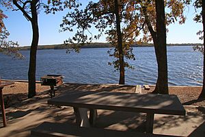
Big Hill Lake (2015)
|
|

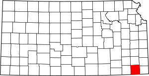
Location within the U.S. state of Kansas
|
|
 Kansas's location within the U.S. |
|
| Country | |
| State | |
| Founded | February 26, 1867 |
| Named for | Pierre La Bette |
| Seat | Oswego |
| Largest city | Parsons |
| Area | |
| • Total | 653 sq mi (1,690 km2) |
| • Land | 645 sq mi (1,670 km2) |
| • Water | 7.8 sq mi (20 km2) 1.2%% |
| Population
(2020)
|
|
| • Total | 20,184 |
| • Density | 31.3/sq mi (12.1/km2) |
| Time zone | UTC−6 (Central) |
| • Summer (DST) | UTC−5 (CDT) |
| Area code | 620 |
| Congressional district | 2nd |
Labette County is a county located in Southeast Kansas. Its main city, called the county seat, is Oswego. The biggest city in the county is Parsons.
In 2020, about 20,184 people lived in Labette County. The county got its name from LaBette Creek. This creek was named after Pierre LaBette, a French-Canadian fur trapper. He lived along the Neosho River and married into the Osage tribe in the 1830s and 1840s.
Contents
History of Labette County
In the 1840s, most people living in Labette County were Osage people. There were also many Cherokee people and some Euro-Americans. Many of these Euro-Americans were merchants who had married Osage or Cherokee women.
Between 1871 and 1873, several people disappeared near an inn and store. This place was run by the Bender family in Labette County. After the Benders themselves disappeared in 1873, it was found that many travelers had gone missing from their property. Between eight and eleven bodies were discovered buried there. The governor at the time, Thomas A. Osborn, offered a reward to find the Benders, but they were never seen again.
Geography of Labette County
Labette County covers a total area of about 653 square miles. Most of this area, about 645 square miles, is land. The remaining 7.8 square miles, or 1.2%, is water.
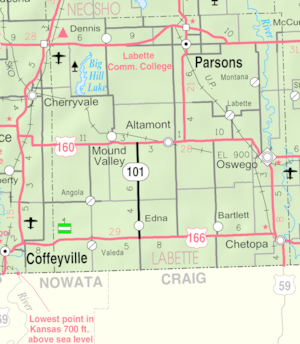
Neighboring Counties
Labette County shares its borders with several other counties:
- Neosho County (to the north)
- Crawford County (to the northeast)
- Cherokee County (to the east)
- Craig County, Oklahoma (to the south)
- Nowata County, Oklahoma (to the southwest)
- Montgomery County (to the west)
Population of Labette County
| Historical population | |||
|---|---|---|---|
| Census | Pop. | %± | |
| 1870 | 9,973 | — | |
| 1880 | 22,735 | 128.0% | |
| 1890 | 27,586 | 21.3% | |
| 1900 | 27,387 | −0.7% | |
| 1910 | 31,423 | 14.7% | |
| 1920 | 34,047 | 8.4% | |
| 1930 | 31,346 | −7.9% | |
| 1940 | 30,352 | −3.2% | |
| 1950 | 29,285 | −3.5% | |
| 1960 | 26,805 | −8.5% | |
| 1970 | 25,775 | −3.8% | |
| 1980 | 25,682 | −0.4% | |
| 1990 | 23,693 | −7.7% | |
| 2000 | 22,169 | −6.4% | |
| 2010 | 21,607 | −2.5% | |
| 2020 | 20,184 | −6.6% | |
| 2023 (est.) | 19,728 | −8.7% | |
| U.S. Decennial Census 1790-1960 1900-1990 1990-2000 2010-2020 |
|||
The Parsons, KS Micropolitan Statistical Area includes all of Labette County. This means Parsons is a central city for a smaller region.
In 2010, Labette County had a population of 21,607 people. The average age was 41 years old. Most of the people, about 85.5%, were non-Hispanic white. Other groups included African-American (4.7%), Native American (2.2%), and Asian (0.4%). About 4.0% of the population was Hispanic or Latino.
Education in Labette County
Labette County has several schools and a college.
Colleges
- Labette Community College
School Districts
Here are the unified school districts in Labette County:
- Parsons USD 503
- Oswego USD 504
- Chetopa–St. Paul USD 505
- Labette County USD 506
Some students in Labette County might also attend schools in a district with an office in a neighboring county:
- Southeast USD 247
Communities in Labette County
Labette County has several cities and smaller communities.
Cities
Unincorporated Communities
These are smaller communities that are not officially cities. A dagger (†) means the United States Census Bureau counts it as a Census-Designated Place (CDP).
Ghost Towns
- Mortimer
See also
 In Spanish: Condado de Labette para niños
 | Jewel Prestage |
 | Ella Baker |
 | Fannie Lou Hamer |


