Nowata County, Oklahoma facts for kids
Quick facts for kids
Nowata County
|
|
|---|---|

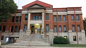
Nowata County Courthouse in Nowata (2016)
|
|

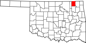
Location within the U.S. state of Oklahoma
|
|
 Oklahoma's location within the U.S. |
|
| Country | |
| State | |
| Founded | 1907 |
| Seat | Nowata |
| Largest city | Nowata |
| Area | |
| • Total | 581 sq mi (1,500 km2) |
| • Land | 566 sq mi (1,470 km2) |
| • Water | 15 sq mi (40 km2) 2.6%% |
| Population
(2020)
|
|
| • Total | 9,320 |
| • Density | 16.041/sq mi (6.194/km2) |
| Congressional district | 2nd |
Nowata County is a county located in the northeastern part of Oklahoma, United States. It sits right on the border with Kansas. In 2020, about 9,320 people lived here. The main town and county seat is Nowata. The county's name comes from a Delaware word, no-we-ata, which means "come here" or "welcome."
Contents
History of Nowata County

For thousands of years, the land that is now Oklahoma was home to many Native American tribes. Scientists have found proof that people lived in the Verdigris River valley over six thousand years ago.
In the 1600s, early European trappers visited the area. They found it was mostly lived in by the Osage and Quapaw tribes. The United States gained this land as part of the Louisiana Purchase in 1803. At that time, it was recognized as Osage territory.
Later, in 1828, a special agreement was made with the Cherokee Nation. This agreement gave the area of Nowata County to the Cherokees. In 1856, the Cherokees included it in their new Cooweescoowee District. In 1867, the Cherokees and the Delaware tribes signed another agreement. This led to Delaware settlements near the towns we now know as Delaware, Lenapah, and Nowata.
Nowata County and the state of Oklahoma were officially created in 1907. At that time, the county had a population of 10,453 people. The town of Nowata was chosen as the county seat. The exact reason for its name is a bit of a mystery. One story says railroad workers used the Delaware word noweta for "welcome." Another story suggests a sign was put up saying local springs had "no water," which sounded like "Nowata."
Geography of Nowata County
Nowata County covers a total area of about 581 square miles. Most of this is land (566 square miles), and about 15 square miles (2.6%) is water.
The Verdigris River flows through the county, splitting it into two parts: an eastern and a western side. Some creeks in the far western part of the county flow into the Caney River. All other creeks in the county flow into the Verdigris River. A part of Lake Oologah is also located in Nowata County.
Major Roads in Nowata County
Neighboring Counties
Nowata County shares its borders with several other counties:
- Montgomery County, Kansas (to the north)
- Labette County, Kansas (to the northeast)
- Craig County (to the east)
- Rogers County (to the south)
- Washington County (to the west)
Population of Nowata County
| Historical population | |||
|---|---|---|---|
| Census | Pop. | %± | |
| 1910 | 14,223 | — | |
| 1920 | 15,899 | 11.8% | |
| 1930 | 13,611 | −14.4% | |
| 1940 | 15,774 | 15.9% | |
| 1950 | 12,734 | −19.3% | |
| 1960 | 10,848 | −14.8% | |
| 1970 | 9,773 | −9.9% | |
| 1980 | 11,486 | 17.5% | |
| 1990 | 9,992 | −13.0% | |
| 2000 | 10,569 | 5.8% | |
| 2010 | 10,536 | −0.3% | |
| 2020 | 9,320 | −11.5% | |
| U.S. Decennial Census 1790-1960 1900-1990 1990-2000 2010 |
|||
According to the census in 2000, there were 10,569 people living in Nowata County. The population density was about 7 people per square kilometer (or 18 people per square mile).
The population was made up of different groups. About 72% of the people were White, and about 16% were Native American. A small percentage were Black or African American, Asian, or from other racial backgrounds. About 1% of the population identified as Hispanic or Latino.
The median age in the county was 39 years old. This means half the people were younger than 39, and half were older.
Economy of Nowata County
The main way people in Nowata County make a living is through agriculture. The most important crops grown here are wheat, corn, oats, and sorghum. Raising cattle is also a very important part of the local economy.
Communities in Nowata County
Nowata County has several towns and communities.
City
- Nowata (This is the county seat, where the main government offices are.)
Towns
Unincorporated Communities
These are smaller places that are not officially organized as cities or towns.
- Alluwe (This is a ghost town, meaning it's mostly abandoned.)
- Watova (This is a census-designated place, which means it's a community identified by the census bureau.)
- Childers
Historic Places in Nowata County
Several places in Nowata County are listed on the National Register of Historic Places. This means they are important historical sites that are protected.
- Cemetery Patent 110, Delaware
- Diamond Point School, Nowata
- Nowata County Courthouse, Nowata
See also
 In Spanish: Condado de Nowata para niños
 | Victor J. Glover |
 | Yvonne Cagle |
 | Jeanette Epps |
 | Bernard A. Harris Jr. |

