Nowata, Oklahoma facts for kids
Quick facts for kids
Nowata, Oklahoma
Nuwatu, Nuwi ta, ᎠᎹᏗᎧᏂᎬᎬ, A-ma-di-ka-ni-gunh-gunh
|
|
|---|---|

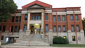
Nowata County Courthouse (2016)
|
|

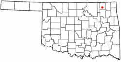
Location of Nowata within Oklahoma
|
|
| Country | United States |
| State | Oklahoma |
| County | Nowata |
| Area | |
| • Total | 3.41 sq mi (8.83 km2) |
| • Land | 3.40 sq mi (8.82 km2) |
| • Water | 0.00 sq mi (0.01 km2) |
| Elevation | 696 ft (212 m) |
| Population
(2020)
|
|
| • Total | 3,517 |
| • Density | 1,032.89/sq mi (398.83/km2) |
| Time zone | UTC-6 (Central (CST)) |
| • Summer (DST) | UTC-5 (CDT) |
| ZIP code |
74048
|
| Area code(s) | 539/918 |
| FIPS code | 40-52900 |
| GNIS ID | 2411285 |
Nowata is a city in Oklahoma, United States. It is also the main city of Nowata County, Oklahoma. In 2020, about 3,517 people lived there. The area where Nowata was built used to be part of the Cherokee Nation.
Contents
History of Nowata
The first settlement here was called Metz. It was named after its first postmaster, Fred Metzner. The name was changed to Nowata before the railroad was built in 1889.
Nowata became a train stop for Native Americans moving from the East. There are different ideas about what the name "Nowata" means. The Lenape people, who passed through, called it "nuwita." This word means "friendly" or "welcome." In the Cherokee language, the town is called ᎠᎹᏗᎧᏂᎬᎬ. This sounds like "water is all gone," which led to the name "No Water."
In 1889, a railway line was built through Nowata. A post office opened in the town on November 8, 1889. Nowata officially became a city on April 17, 1899. By 1900, 498 people lived in Nowata.
Oil and natural gas were found nearby in 1904. This discovery helped Nowata's economy grow a lot. The area became known as the "world's largest shallow oil field." Some of these oil wells are still producing oil today!
In 1904, a special court was set up in Nowata. It met in the First National Bank building. This building burned down in 1909, and all the court records were lost. When Oklahoma became a state on November 16, 1907, Nowata County was created. The city of Nowata was chosen as the county seat, which means it's the main city for the county government. By then, the city's population had grown to 2,233 people. A new courthouse was finished in 1912. It is still used today and is an important historical building.
Nowata's population was highest in 1920, with 4,435 people. The city also had a special electric railway until 1948. Local newspapers like the Nowata Herald kept people informed. By 1930, there were 850 telephones in town. However, the population started to decrease after 1920.
Nowata's Location and Weather
Nowata is located about 51 miles (82 km) north of Tulsa. It is also 21 miles (34 km) south of the Kansas state line. The city covers an area of about 3.1 square miles (8.0 km2), and it's all land.
Nowata's Climate
Nowata holds the record for the coldest temperature ever recorded in Oklahoma. On February 10, 2011, the temperature dropped to -31 °F (-35 °C). Just one week later, the temperature rose to 79 °F (26 °C). That's a huge change of 110 degrees!
Population Changes
Nowata's population has changed over the years. Here's how many people have lived there during different census years:
| Historical population | |||
|---|---|---|---|
| Census | Pop. | %± | |
| 1900 | 498 | — | |
| 1910 | 3,672 | 637.3% | |
| 1920 | 4,435 | 20.8% | |
| 1930 | 3,531 | −20.4% | |
| 1940 | 3,904 | 10.6% | |
| 1950 | 3,965 | 1.6% | |
| 1960 | 4,163 | 5.0% | |
| 1970 | 3,679 | −11.6% | |
| 1980 | 4,270 | 16.1% | |
| 1990 | 3,896 | −8.8% | |
| 2000 | 3,971 | 1.9% | |
| 2010 | 3,731 | −6.0% | |
| 2020 | 3,517 | −5.7% | |
| U.S. Decennial Census | |||
In 2000, there were 3,971 people living in Nowata. About 70% of the people were White, 4.6% were African American, and 16% were Native American. About 28.7% of households had children under 18. The average age of people in Nowata was 40 years old.
Nowata's Economy
At the start of the 21st century, Nowata had about 130 different businesses. A very important one was the Jane Phillips Nowata Health Center, which had forty beds. The local newspaper, the Nowata Star, kept everyone updated on what was happening in town.
Getting Around Nowata
Nowata has good transportation options. It is served by two major U.S. highways, an airport, and a railroad.
Highways in Nowata
- US-169 is the main highway that runs north and south through Nowata. It goes through the city and continues south towards Tulsa.
- US-60 is the main highway that runs east and west through Nowata. It crosses US-169 and continues west towards Bartlesville.
Nowata Municipal Airport
Nowata has its own airport, located on the north side of the city. It has two runways. One is paved with asphalt and is 2,500 feet (760 m) long. The other is a grass runway, also 2,500 feet (760 m) long. The City of Nowata owns and operates this airport.
Railroad in Nowata
The Union Pacific Railroad serves Nowata. Its tracks run through Nowata County, connecting towns like Coffeyville, Kansas, and Van Buren, Arkansas. This railroad helps move goods and materials through the region.
Nowata in Movies
Nowata was the setting for a movie called Possums in 1998. In the movie, a character played by Mac Davis tries to bring back the town's high school football program. Some scenes were filmed right in Nowata, and many local people even appeared in the movie!
Famous People from Nowata
- Kurt Burris, a football player
- Flora Campbell, an actress who starred in the first network TV soap opera
- Julian Wood Glass Jr., a businessman and helper of good causes
- Lulu M. Hefner, the first woman to successfully drill an oil well
- Ray Starr, a baseball player
See also
 In Spanish: Nowata (Oklahoma) para niños
 | John T. Biggers |
 | Thomas Blackshear |
 | Mark Bradford |
 | Beverly Buchanan |

