
Lenapah, Oklahoma facts for kids
Quick facts for kids
Lenapah, Oklahoma
|
|
|---|---|

Location of Lenapah, Oklahoma
|
|
| Country | United States |
| State | Oklahoma |
| County | Nowata |
| Area | |
| • Total | 0.41 sq mi (1.07 km2) |
| • Land | 0.41 sq mi (1.07 km2) |
| • Water | 0.00 sq mi (0.00 km2) |
| Elevation | 755 ft (230 m) |
| Population
(2020)
|
|
| • Total | 272 |
| • Density | 660.19/sq mi (255.10/km2) |
| Time zone | UTC-6 (Central (CST)) |
| • Summer (DST) | UTC-5 (CDT) |
| ZIP code |
74042
|
| Area code(s) | 539/918 |
| FIPS code | 40-42300 |
| GNIS feature ID | 2412889 |
Lenapah is a small town located in the northern part of Nowata County, Oklahoma, in the United States. It is about eleven miles north of the city of Nowata and sixty-two miles northeast of Tulsa. The town's name comes from the Lenape people, also known as the Delaware Tribe of Indians. In 2020, the population of Lenapah was 272 people.
Contents
History of Lenapah
Lenapah started mainly as a farming community.
Early Days and Growth
- In 1889, the Kansas and Arkansas Valley Railway built a train station in Lenapah. This railway is now part of the Union Pacific Railroad.
- A post office opened in Lenapah the very next year, in 1890.
- By 1900, 154 people lived in the town.
- When Oklahoma became a state in 1907, Lenapah's population had grown to 331.
- The town's largest population was 434 people in 1920.
Oil and Gas Discoveries
After the early 1900s, oil and natural gas were found near Lenapah. Even though this didn't make the town much bigger, it did help by bringing natural gas to homes and businesses in Lenapah.
Geography of Lenapah
Lenapah is located in a flat area of Oklahoma.
Location and Nearby Features
- The town is just west of US Route 169, a major highway.
- It is about fourteen miles south of Coffeyville, Kansas.
- The community of Delaware is about 4.5 miles north of Lenapah.
- The Verdigris River flows about six miles to the east of the town.
Area Size
According to the United States Census Bureau, the town of Lenapah covers an area of about 0.4 square miles (1.07 square kilometers). All of this area is land.
People of Lenapah (Demographics)
| Historical population | |||
|---|---|---|---|
| Census | Pop. | %± | |
| 1900 | 154 | — | |
| 1910 | 412 | 167.5% | |
| 1920 | 434 | 5.3% | |
| 1930 | 336 | −22.6% | |
| 1940 | 395 | 17.6% | |
| 1950 | 328 | −17.0% | |
| 1960 | 322 | −1.8% | |
| 1970 | 325 | 0.9% | |
| 1980 | 350 | 7.7% | |
| 1990 | 253 | −27.7% | |
| 2000 | 298 | 17.8% | |
| 2010 | 293 | −1.7% | |
| 2020 | 272 | −7.2% | |
| U.S. Decennial Census | |||
The information below is based on the census from the year 2000.
Population Details
- In 2000, there were 298 people living in Lenapah.
- There were 109 households, and 81 of these were families.
- The average household had about 2.73 people.
- The average family had about 3.12 people.
Age Groups
The population in 2000 was spread out by age:
- About 31.9% of the people were under 18 years old.
- About 8.1% were between 18 and 24 years old.
- About 28.9% were between 25 and 44 years old.
- About 18.5% were between 45 and 64 years old.
- About 12.8% were 65 years old or older.
- The average age of people in Lenapah was 34 years.
Income Information
- In 2000, the typical income for a household in Lenapah was about $29,688 per year.
- For families, the typical income was about $35,357 per year.
- About 17.3% of all people in Lenapah lived below the poverty line. This included about 18.5% of those under 18 and 22.0% of those 65 or older.
Notable People
Some well-known people have connections to Lenapah:
- Al Downing – a musician
- Chris Penn – a football player
Images for kids
-
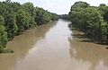
The Verdigris River near Lenapah, Oklahoma

See also
 In Spanish: Lenapah (Oklahoma) para niños
