South Coffeyville, Oklahoma facts for kids
Quick facts for kids
South Coffeyville, Oklahoma
|
|
|---|---|
| Nickname(s):
South Town
|
|

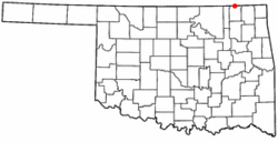
Location of South Coffeyville, Oklahoma
|
|
| Country | United States |
| State | Oklahoma |
| County | Nowata |
| Government | |
| • Type | Council |
| Area | |
| • Total | 0.74 sq mi (1.91 km2) |
| • Land | 0.74 sq mi (1.91 km2) |
| • Water | 0.00 sq mi (0.00 km2) |
| Elevation | 722 ft (220 m) |
| Population
(2020)
|
|
| • Total | 683 |
| • Density | 925.47/sq mi (357.42/km2) |
| Time zone | UTC-6 (Central (CST)) |
| • Summer (DST) | UTC-5 (CDT) |
| ZIP code |
74072
|
| Area code(s) | 539/918 |
| FIPS code | 40-68600 |
| GNIS feature ID | 2413306 |
South Coffeyville is a small town in Nowata County, Oklahoma, in the United States. In 2010, about 785 people lived there. The larger city of Coffeyville, Kansas is just one mile north. Even though they are close, they are separate towns.
Contents
A Look Back in Time

For thousands of years, the land that is now Oklahoma was home to Native American tribes. In the 1600s, early European visitors found the Osage and Quawpaw tribes living here.
In 1803, the United States gained this area as part of the Louisiana Purchase. Later, in 1828, a treaty gave the area of Nowata County to the Cherokee Nation. They made it part of their Cooweescoowee District in 1856.
In 1907, Oklahoma became the 46th state in the U.S. That's when Nowata County was officially created.
How South Coffeyville Started
The first settlement in this area was called Stevens. It started in 1888 as a small village for railroad workers. It was named after a railroad builder. Stevens was on maps until about 1902, then it was left behind.
In 1906, another settlement named Polson was built. It was about a mile northeast, near the railroad tracks. This place was named after early settlers, Martin and Earl Polson. But this name also didn't last long.
On March 18, 1909, a post office opened. The settlement was then renamed Etchen, honoring a local person named John P. Etchen.
Finally, on April 29, 1909, the settlement got its current name: South Coffeyville. Soon after, a local newspaper called the South Coffeyville Times began. In August 1909, people voted for the town to become official. The name "South Coffeyville" comes from the nearby city of Coffeyville, Kansas. That city was named after James A. Coffey.
Where is South Coffeyville?
South Coffeyville is located on US Route 169. It is just south of the border between Oklahoma and Kansas. The city of Coffeyville, Kansas is only 2.5 miles north.
A stream called Onion Creek flows past the north side of the town. It then joins the Verdigris River about 1.5 miles to the east.
The town covers an area of about 0.6 square miles (1.6 square kilometers). All of this area is land.
Who Lives in South Coffeyville?
| Historical population | |||
|---|---|---|---|
| Census | Pop. | %± | |
| 1910 | 196 | — | |
| 1920 | 179 | −8.7% | |
| 1930 | 271 | 51.4% | |
| 1940 | 364 | 34.3% | |
| 1950 | 527 | 44.8% | |
| 1960 | 622 | 18.0% | |
| 1970 | 646 | 3.9% | |
| 1980 | 873 | 35.1% | |
| 1990 | 791 | −9.4% | |
| 2000 | 300 | −62.1% | |
| 2010 | 785 | 161.7% | |
| 2020 | 683 | −13.0% | |
| U.S. Decennial Census | |||
In 2000, there were 790 people living in South Coffeyville. They lived in 329 homes, and 228 of these were families. The town had about 1,285 people per square mile.
Most of the people in town were White (about 84.8%). About 9.6% were Native American. About 5.2% were from two or more racial backgrounds. A small number (1.9%) were Hispanic or Latino.
About 33.4% of homes had children under 18 living there. Many homes (54.7%) were married couples. About 15.5% of homes had someone living alone who was 65 or older.
The average age of people in the town was 37 years old. About 26.6% of the population was under 18. About 17.2% were 65 years or older.
In 2000, the average income for a household in town was about $29,688 per year. For families, the average income was about $37,109.
Businesses and Jobs
South Coffeyville has several local businesses. You can find two convenience stores and three hair salons. There is also a thrift store, a bar, and a barber shop.
For car repairs, there are two transmission shops. The town also has a bank and a chiropractor. You can find a rural medical clinic and a city library.
Other businesses include a salvage yard, a lumber yard, and a furniture restoration shop. The South Coffeyville Stockyards are an important part of the community's economy. There are also four churches in the town.
The town has its own police department. It also has a volunteer fire department to help keep everyone safe.
Getting Around
US Route 169 is the main highway that serves South Coffeyville.
If you need to travel by bus, Jefferson Lines offers service from Coffeyville, Kansas.
The Coffeyville Municipal Airport is about 9 miles north-northeast of town. It has two runways for planes.
For bigger flights, the Tulsa International Airport is about 63 miles south.
Famous Faces
- Gail Kubik was a composer, who wrote music for movies. He was also a violinist and a teacher.
See also
 In Spanish: South Coffeyville (Oklahoma) para niños
 | DeHart Hubbard |
 | Wilma Rudolph |
 | Jesse Owens |
 | Jackie Joyner-Kersee |
 | Major Taylor |

