
Montgomery County, Kansas facts for kids
Quick facts for kids
Montgomery County
|
|
|---|---|

Memorial Hall in Independence (2017)
|
|

Location within the U.S. state of Kansas
|
|
 Kansas's location within the U.S. |
|
| Country | |
| State | |
| Founded | February 26, 1867 |
| Named for | Richard Montgomery |
| Seat | Independence |
| Largest city | Coffeyville |
| Area | |
| • Total | 651 sq mi (1,690 km2) |
| • Land | 644 sq mi (1,670 km2) |
| • Water | 8.0 sq mi (21 km2) 1.2%% |
| Population
(2020)
|
|
| • Total | 31,486 |
| • Estimate
(2023)
|
30,568 |
| • Density | 48.9/sq mi (18.9/km2) |
| Time zone | UTC−6 (Central) |
| • Summer (DST) | UTC−5 (CDT) |
| Area code | 620 |
| Congressional district | 2nd |
Montgomery County is a place in Southeast Kansas. It is a county, which is like a local government area. The main town, or county seat, is Independence. The biggest city in the county is Coffeyville.
In 2020, about 31,486 people lived here. The county got its name from Richard Montgomery. He was an important general during the American Revolutionary War.
Contents
History of Montgomery County
Early Days
For thousands of years, the Great Plains of North America were home to nomadic Native American tribes. They moved around to hunt and gather food.
From the 1500s to the 1700s, France said they owned large parts of North America. After a war in 1762, France secretly gave this land to Spain. This was part of a deal called the Treaty of Fontainebleau.
The 1800s
In 1802, Spain gave most of the land back to France. Then, in 1803, the United States bought a huge area from France. This was called the Louisiana Purchase. It included most of what is now Kansas. The U.S. paid a very small amount for each acre.
In 1854, the Kansas Territory was set up. Then, in 1861, Kansas became the 34th U.S. state. Montgomery County was officially created on February 26, 1867.
It was named after Richard Montgomery. He was an American Revolutionary War general. He died in 1775 while trying to capture Quebec City in Canada. Before that, he had successfully captured two forts and the city of Montreal.
When Kansas became a state, the Osage Indian reservation was a large area nearby. This reservation was created in 1825. After the Civil War, people wanted the Osage lands. They were the last good lands in eastern Kansas.
By 1866, the Osages had to give up some of their land. This allowed white settlers to move into parts of what is now Montgomery County.
For a short time, the Osages tried to keep a border at the Verdigris River. This river flows through the middle of Montgomery County. In 1867, two men named Frank and Fred Bunker set up a cattle camp there. They thought they were outside settled areas.
But by 1869, many settlers started crossing the Verdigris River. The Osage people protested, but too many settlers arrived. Montgomery County was surveyed and organized in 1869. The governor appointed officials on June 3.
Geography of Montgomery County
According to the U.S. Census Bureau, Montgomery County covers about 651 square miles. About 644 square miles are land, and 8.0 square miles (1.2%) are water.
The lowest place in Kansas is in Montgomery County. It's on the Verdigris River, near Coffeyville. This is where the river flows out of Kansas into Oklahoma.
Some western parts of the county are in the northern Cross Timbers area. This area has trees and separates the forests of the eastern U.S. from the open plains.
Did you know? Google Maps uses a spot in Fawn Creek Township, within Montgomery County, as the "zero-mile point" for the United States. This means that if you ask for directions to the "United States," it will lead you to this spot!
Neighboring Counties
- Wilson County (north)
- Neosho County (northeast)
- Labette County (east)
- Nowata County, Oklahoma (southeast)
- Washington County, Oklahoma (south)
- Chautauqua County (west)
- Elk County (northwest)
Rivers and Lakes
- Elk City Lake
- Elk River
- Havana Lake
- Liberty Lakes
- State Lake
- Verdigris River
State Parks
- Elk City State Park
- Montgomery County State Park
People of Montgomery County

| Historical population | |||
|---|---|---|---|
| Census | Pop. | %± | |
| 1870 | 7,564 | — | |
| 1880 | 18,213 | 140.8% | |
| 1890 | 23,104 | 26.9% | |
| 1900 | 29,039 | 25.7% | |
| 1910 | 49,474 | 70.4% | |
| 1920 | 49,645 | 0.3% | |
| 1930 | 51,411 | 3.6% | |
| 1940 | 49,729 | −3.3% | |
| 1950 | 46,487 | −6.5% | |
| 1960 | 45,007 | −3.2% | |
| 1970 | 39,949 | −11.2% | |
| 1980 | 42,281 | 5.8% | |
| 1990 | 38,816 | −8.2% | |
| 2000 | 36,252 | −6.6% | |
| 2010 | 35,471 | −2.2% | |
| 2020 | 31,486 | −11.2% | |
| 2023 (est.) | 30,568 | −13.8% | |
| U.S. Decennial Census 1790-1960 1900-1990 1990-2000 2010-2020 |
|||
The population of Montgomery County has changed over the years. In 1870, there were about 7,564 people. The population grew a lot in the early 1900s, reaching almost 50,000 people by 1910. Since then, the number of people living in the county has slowly decreased. In 2020, the population was 31,486.
Most people in the county are White. There are also groups of Black, Native American, and Asian people. Some residents are of Hispanic or Latino background.
Getting Around Montgomery County
Main Roads
 U.S. Route 75
 U.S. Route 160
 U.S. Route 166
 U.S. Route 169
 U.S. Route 400
Bus Service
- Jefferson Lines
Airports
- Coffeyville Municipal Airport
- Independence Municipal Airport
Learning in Montgomery County
Colleges
- Coffeyville Community College
- Independence Community College
School Districts
- Caney Valley USD 436
- Coffeyville USD 445
- Independence USD 446
- Cherryvale USD 447
Communities of Montgomery County

Here are the cities and towns you can find in Montgomery County:
Cities
- Caney
- Cherryvale
- Coffeyville
- Dearing
- Elk City
- Havana
- Independence (This is the county seat!)
- Liberty
- Tyro
Unincorporated Communities
These are smaller communities that are not officially cities. Some are called "Census-Designated Places" (CDP) by the United States Census Bureau.
Ghost Towns
- Le Hunt
Images for kids
-
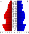
This chart shows the age groups of people in Montgomery County based on the 2000 census.
-
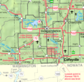
This map shows the different communities in Montgomery County.
See also
 In Spanish: Condado de Montgomery (Kansas) para niños
